Angle measurement/differential velocity measurement/differential distance measurement combined navigation method of deep space probe

A differential and angle measurement technology, which is applied in the direction of integrated navigators, can solve the problems that affect the navigation accuracy and cannot provide position information, etc.

Active Publication Date: 2017-08-08
BEIHANG UNIV
View PDF9 Cites 16 Cited by
  • Summary
  • Abstract
  • Description
  • Claims
  • Application Information

AI Technical Summary

Problems solved by technology

However, this method cannot provide position information, and the dynamic change of stellar spectrum will affect its navigation accuracy

Method used


Image

  • Angle measurement/differential velocity measurement/differential distance measurement combined navigation method of deep space probe
  • Angle measurement/differential velocity measurement/differential distance measurement combined navigation method of deep space probe
  • Angle measurement/differential velocity measurement/differential distance measurement combined navigation method of deep space probe

Examples


Embodiment Construction

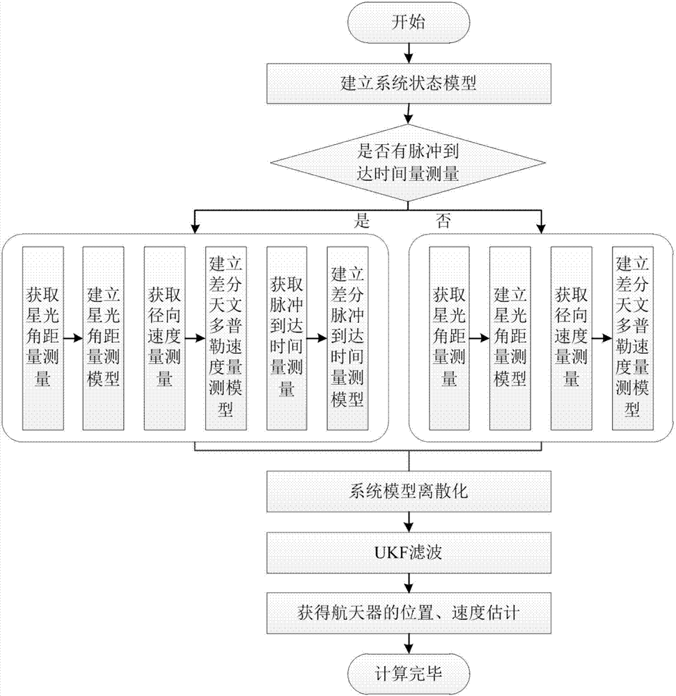
[0062] figure 1 The system flow chart of the integrated navigation method of angle measurement / differential velocity measurement / differential ranging measurement of deep space probe is given. Here, taking the approaching section of Mars exploration as an example, the specific implementation process of the present invention is described in detail:

[0063] 1. Establish a system state model based on orbital dynamics

[0064] The motion of the spacecraft during the approach to Mars is described as a heliocentric three-body model, and other perturbations are considered as process noise. The dynamic model in the sun center inertial coordinate system (J2000.0) can be written as:

[0065]

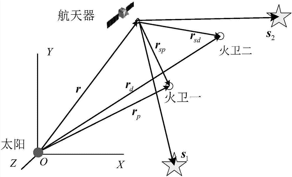
[0066] Where ||·|| represents the 2-norm of the vector, ||·|| 3 Represents the cube of ||·||, r and v are the position and velocity of the spacecraft relative to the sun. mu s and μ m are the gravitational constants of the sun and Mars, r m is the position vector of Mars relative to the ...


PUM


Abstract

The invention relates to an angle measurement / differential velocity measurement / differential distance measurement combined navigation method of a deep space probe. The method comprises the following steps: establishing a state model of a spacecraft according to orbital dynamics, adopting an angle measurement sensor to obtain a starlight angle distance measured value, adopting an X-ray pulsar probe to obtain a pulse arrival time measured value, adopting a spectrograph to obtain an astronomical Doppler velocity measured value, and then respectively establishing a starlight angle distance measured model, a differential pulse arrival time measured model and a differential astronomical Doppler velocity measured model according to the measured values. The position and the velocity of the spacecraft are estimated through UKF filter after discretization. The method belongs to the field of autonomous navigation of the spacecraft, is high in estimated accuracy, and has important practical significance for the autonomous navigation of the spacecraft.

Description

technical field [0001] The invention belongs to the field of autonomous navigation of spacecraft, and relates to an autonomous astronomical navigation method based on the measurement of starlight angular distance, differential pulse arrival time, and differential astronomical Doppler velocity. Background technique [0002] my country plans to launch a Mars probe in 2020, so Mars exploration will attract more and more attention. For deep space exploration missions, navigation accuracy has an important impact on the success or failure of the mission. At present, the navigation information is mainly provided for the spacecraft through the ground measurement and control station. As the distance between the spacecraft and the earth increases, the round-trip delay of signal transmission through the ground monitoring and control station will become larger and larger. In addition, the sun transit will cause signal interruption. Therefore, it is necessary to improve the autonomous...

Claims


Application Information

Patent Timeline
Patent Type & Authority Applications(China)
IPC IPC(8): G01C21/24
CPCG01C21/24
Inventor 宁晓琳桂明臻吴伟仁房建成刘刚孙晓函
Owner BEIHANG UNIV
Why Eureka
Try Eureka