
Method for realizing Beidou/GPS (Beidou/Global Positioning System) integrated navigation under Windows CE (Embedded Compact) system

A technology of GPS navigation and integrated navigation, applied in the direction of radio wave measurement system, satellite radio beacon positioning system, measurement device, etc., can solve the problem of limited positioning accuracy, achieve the effect of improving navigation positioning accuracy and avoiding mutual interference

Inactive Publication Date: 2015-03-04
SHANDONG CHAOYUE DATA CONTROL ELECTRONICS CO LTD
View PDF4 Cites 9 Cited by
  • Summary
  • Abstract
  • Description
  • Claims
  • Application Information

AI Technical Summary

Problems solved by technology

Application At present, the positioning accuracy of the single-mode Beidou satellite navigation is limited. In order to further improve the navigation positioning accuracy, reliability and redundancy of the satellite navigation system in the field of mobile terminals

Method used


Image

  • Method for realizing Beidou/GPS (Beidou/Global Positioning System) integrated navigation under Windows CE (Embedded Compact) system
  • Method for realizing Beidou/GPS (Beidou/Global Positioning System) integrated navigation under Windows CE (Embedded Compact) system
  • Method for realizing Beidou/GPS (Beidou/Global Positioning System) integrated navigation under Windows CE (Embedded Compact) system

Examples


Embodiment Construction

[0024] Below with reference to shown in accompanying drawing, the present invention is further described by specific embodiment:

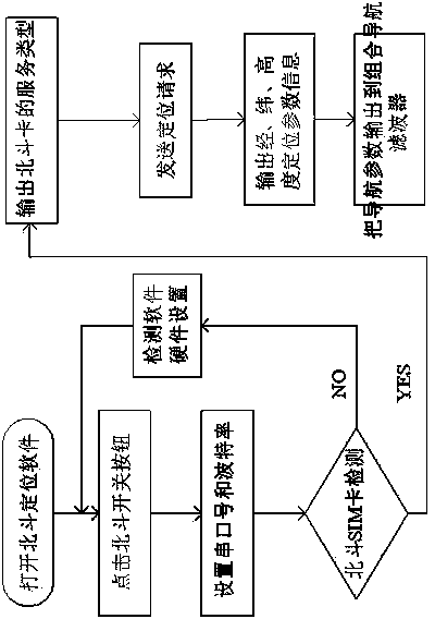
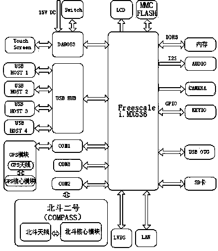
[0025] Such as figure 1 As shown, a method for realizing Beidou / GPS integrated navigation under a Windows CE system, the method is based on a general embedded Beidou satellite navigation and positioning system platform, and the platform system includes a processor module, an input and output module, a navigation and positioning communication modules and display modules, wherein the processor module is the core hardware module of the system, and the navigation positioning communication module is a combined navigation module composed of a GPS navigation module and a COMPASS module. The combined navigation module is installed on a mobile terminal, and the mobile terminal sends a positioning request After the information, the GPS navigation module and the COMPASS module respectively analyze, solve and synthesize the positioning data information, and ou...


PUM


Abstract

The invention discloses a method for realizing Beidou / GPS (Beidou / Global Positioning System) integrated navigation under a Windows CE (Embedded Compact) system. Based on a universal embedded Beidou satellite navigation and positioning system platform, the system platform comprises a processor module, an input / output module, a navigation and positioning communication module and a display module, wherein the processor module is a hardware core module of the system, the navigation and positioning communication module is an integrated navigation module consisting of a GPS navigation module and a COMPASS module, and the integrated navigation module is mounted on a mobile terminal; after positioning request information is sent by the mobile terminal, analysis, resolving and synthesizing of positioning data information are respectively carried out by the GPS navigation module and the COMPASS module, and navigation parameters after the resolving of respective subsystem are output; finally, the optimal estimated values of the navigation parameters are output by an integrated navigation filter. Through the adoption of the technology, the navigation and positioning precision, reliability and redundancy of a satellite navigation system in a mobile terminal field can be further improved, so that the navigation and positioning effects are superior to those of ordinary single navigation systems.

Description

technical field [0001] The present invention specifically relates to a method for realizing Beidou / GPS combined navigation under the Windows CE system, which is mainly used in the field of vehicle navigation or mobile terminal navigation. It adopts the Beidou 2nd generation and American GPS combined navigation method, and makes the two kinds of navigation The method combines advanced filtering algorithm to realize high-precision and high-reliability navigation and positioning. technical background [0002] At present, in the field of domestic navigation products, the application of Beidou navigation products has just started in recent years. The construction of my country's Beidou satellite navigation system has now entered the second stage, and its services have covered most of China and the Asia-Pacific region. The construction of the third phase of Beidou will be completed in 2020. Judging from the actual situation of the second generation of Beidou, because there are fe...

Claims


Application Information

Patent Timeline
Patent Type & Authority Applications(China)
IPC IPC(8): G01S19/48
CPCG01S19/48
Inventor 袁厚亮李圣涛吴登勇
Owner SHANDONG CHAOYUE DATA CONTROL ELECTRONICS CO LTD
Learn More