GNSS observation value fixed weight method conforming to reality

An observation value and weight determination technology, which is applied in the field of satellite navigation and positioning, can solve the problems of large and inaccurate GNSS navigation and positioning errors, and achieve the effects of simple operation, improved accuracy and reliability, and strong implementability

Pending Publication Date: 2020-04-24
HOHAI UNIV
View PDF5 Cites 8 Cited by
  • Summary
  • Abstract
  • Description
  • Claims
  • Application Information

AI Technical Summary

Problems solved by technology

[0005] The purpose of the present invention is to provide a practical GNSS observation value weighting method to solve the defects of large and inaccurate GNSS navigation positioning errors caused in the prior art

Method used


Image

  • GNSS observation value fixed weight method conforming to reality
  • GNSS observation value fixed weight method conforming to reality
  • GNSS observation value fixed weight method conforming to reality

Examples


Embodiment Construction

[0037] In order to make the technical means, creative features, achievement goals and effects realized by the present invention easy to understand, the present invention will be further described below with reference to the specific embodiments.

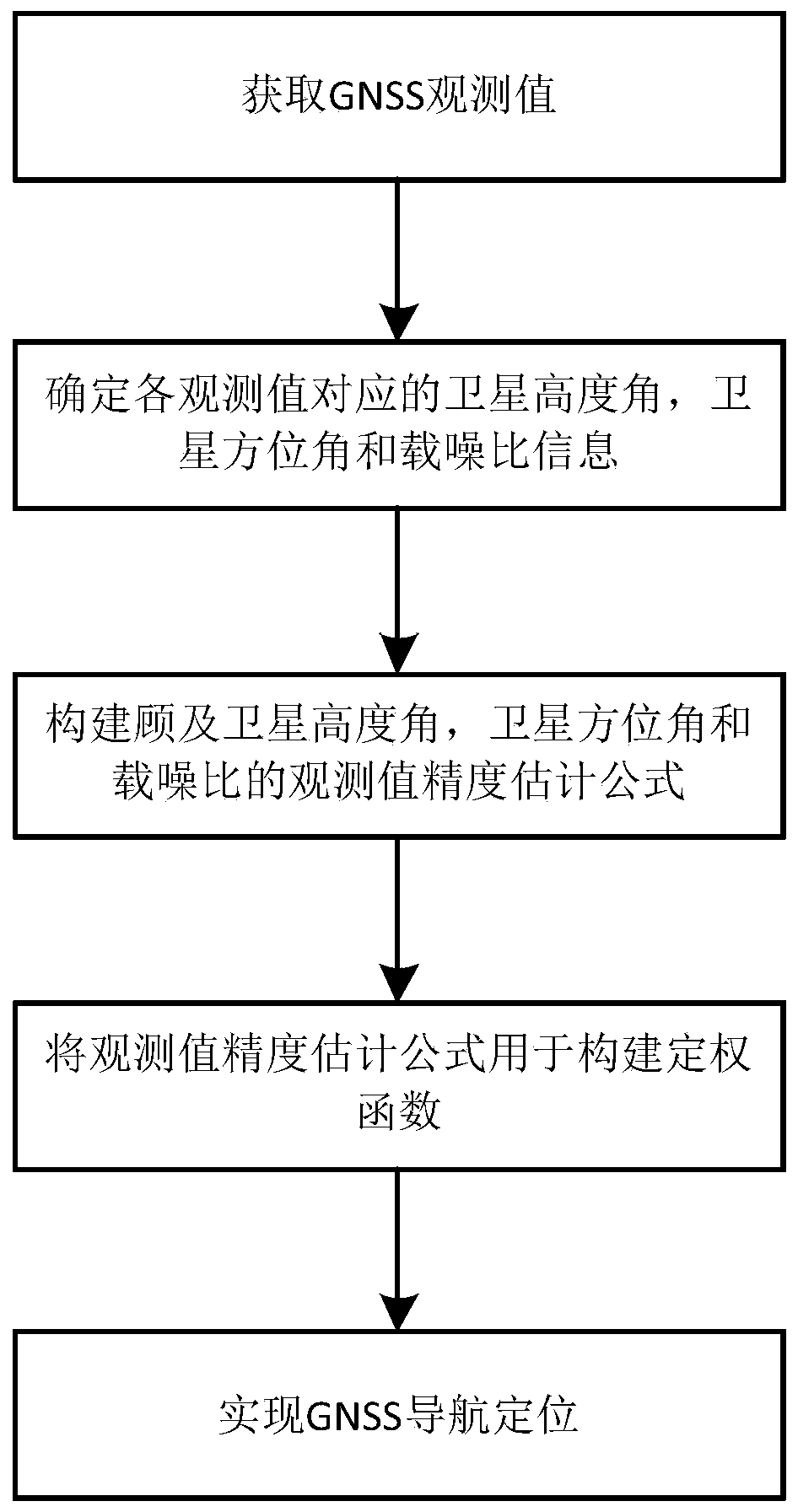
[0038] like figure 1 As shown in the figure, a practical GNSS observation value determination method includes the following steps:

[0039] Step 1: Obtain GNSS observations:

[0040] Obtain global positioning system (GPS) phase observations and pseudorange observations at different frequencies;

[0041] Step 2: Determine the parameter data corresponding to each observation value. The parameter data includes satellite altitude angle, satellite azimuth angle and carrier-to-noise ratio:

[0042] Determining the altitude angle, azimuth angle and carrier-to-noise ratio information corresponding to each observation value firstly obtains the observation file and ephemeris file, and obtains the carrier-to-noise ratio data corresponding to ...


PUM


Abstract

The invention discloses a GNSS observation value fixed weight method conforming to reality. The method comprises the following steps of obtaining a GNSS observation value; determining a satellite elevation angle, a satellite azimuth angle and carrier-to-noise ratio information corresponding to each observation value; constructing a fixed weight function considering the satellite elevation angle, the satellite azimuth angle and a carrier-to-noise ratio; using the fixed weight function to construct a random model; and realizing GNSS navigation positioning. In the method, observation value quality changes caused by some actual environment factors ignored in a traditional observation value fixed weight method are considered, and due to a fact that observation station environment factors are always closely related to the satellite elevation angle, the satellite azimuth angle and the carrier-to-noise ratio, the factors are fully considered, and the corresponding observation value fixed weight method is established. Compared with a traditional weight fixing method, by using the method of the invention, GNSS navigation positioning precision and reliability can be improved.

Description

technical field [0001] The invention relates to the technical field of satellite navigation and positioning, in particular to a method for determining the weight of GNSS observation values ​​that conforms to reality. Background technique: [0002] In the Global Navigation Satellite System (GNSS), it is the premise to achieve high-precision and high-reliability GNSS navigation and positioning to accurately evaluate the accuracy of the observation values, so as to construct a corresponding and accurate weighting function. [0003] Previously, GNSS observations were generally considered to have homoscedasticity, that is, an equal-weight model, which considered all observations to be of equal accuracy, but this method is not applicable in most observational environments. Therefore, in order to overcome the defects of the homoscedasticity of the observations, the fixed weight function of the height angle or the carrier-to-noise ratio is often used to realize the heteroscedasticit...

Claims


Application Information

Patent Timeline
IPC IPC(8): G01S19/44
CPCG01S19/44
Inventor 章浙涛何秀凤艾力库尔班文援兰
Owner HOHAI UNIV
Why Eureka
Try Eureka