An Integrated Vertical Optimization Method of Road Network Based on Feature Points

An optimization method and feature point technology, applied in special data processing applications, instruments, electrical and digital data processing, etc., can solve problems such as labor-intensive

Active Publication Date: 2017-07-11
CHONGQING SURVEY INST
View PDF2 Cites 0 Cited by
  • Summary
  • Abstract
  • Description
  • Claims
  • Application Information

AI Technical Summary

Problems solved by technology

Therefore, in the face of a road network composed of multiple roads, especially in the planning and design of a large-scale regional road network, the overall vertical optimization of the road network will consume a lot of manpower

Method used


Image

  • An Integrated Vertical Optimization Method of Road Network Based on Feature Points
  • An Integrated Vertical Optimization Method of Road Network Based on Feature Points

Examples


Embodiment Construction

[0063] Below in conjunction with accompanying drawing and embodiment, the present invention will be further described:

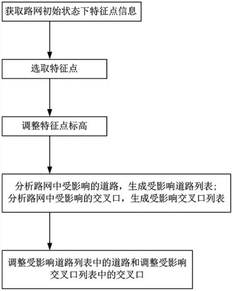
[0064] like figure 1 As shown, a feature point-based road network integrated vertical optimization method includes the following steps:

[0065] Step 1: Obtain feature point information in the initial state of the road network, where the feature point information includes road gradient point feature point information and intersection feature point information.

[0066] Step 2. Select feature points:

[0067] G1. Take the feature points in sequence from the feature point list.

[0068] G2. Display the information of the feature points in the graphics window of the road design software in the form of text or icons, and the displayed information includes the name and elevation of the feature points.

[0069] G3. Select feature points through interactive operation: the interactive operation selection is through mouse click or command line input.

[0070] Ste...


PUM


Abstract

The invention discloses a road network integrated vertical optimization method based on feature points, which belongs to the field of road network optimization. The invention obtains the information of the feature points in the initial state of the road network, and then analyzes the road network according to the change of the elevation of the feature points. Affected roads, generate a list of affected roads and / or analyze affected intersections in the road network, generate a list of affected intersections, and finally adjust roads in the affected roads list and / or adjust the affected intersections list intersection. The invention realizes the reflection of the elevation change of a single feature point to other roads and intersections associated with the feature point in the entire road network, thereby providing a fast optimization method for the road network, which greatly saves manpower and time cost. The invention solves the problem that each road independently stores and manages information in the traditional road design system, and the information cannot be transmitted, and can provide technical support for the optimization of the road network in combination with road earthwork calculation and other contents.

Description

technical field [0001] The invention belongs to the field of road network optimization, in particular to a road network integrated vertical optimization method based on feature points. Background technique [0002] Road design is a complex system engineering. Object-oriented information design is the mainstream technology of road design systems in recent years. Based on object-oriented technology, the system can easily manage every detail of road design results, including road plane curves, Vertical curves, intersections, facilities and other information. Through the object-oriented design pattern, the system can manage the complete information of the design from the macro and micro levels to facilitate the exchange and use of data. [0003] In the road vertical optimization technology, more attention is currently paid to the optimization of a single road. The adjustment of the existing system is all for a single line, without realizing the association between roads and in...

Claims


Application Information

Patent Timeline
Patent Type & Authority Patents(China)
IPC IPC(8): G06F17/50
Inventor 何兴富陈翰新薛梅陈良超胡章杰李响唐相桢
Owner CHONGQING SURVEY INST
Why Eureka
Try Eureka