System and method for positioning ground targets of unmanned planes based on enhanced geographic information

A technology of geographic information and ground targets, applied in the field of UAV ground target positioning system, can solve the problems of complex image processing algorithm, reduce target positioning speed, complex video image background, etc., to achieve simple positioning algorithm, fast positioning speed, satisfying The effect of real-time tracking

Inactive Publication Date: 2015-03-25
PEKING UNIV
View PDF4 Cites 53 Cited by
  • Summary
  • Abstract
  • Description
  • Claims
  • Application Information

AI Technical Summary

Problems solved by technology

However, due to the complex background of the video image, on the one hand, the existing image processing algorithm is complex, which reduces the speed of target positioning; on the other hand, the existing target positioning accuracy is limited. Some target positioning accuracy can no longer meet the demand

Method used


Image

  • System and method for positioning ground targets of unmanned planes based on enhanced geographic information
  • System and method for positioning ground targets of unmanned planes based on enhanced geographic information
  • System and method for positioning ground targets of unmanned planes based on enhanced geographic information

Examples


Embodiment Construction

[0044] The present invention is described in detail below in conjunction with accompanying drawing:

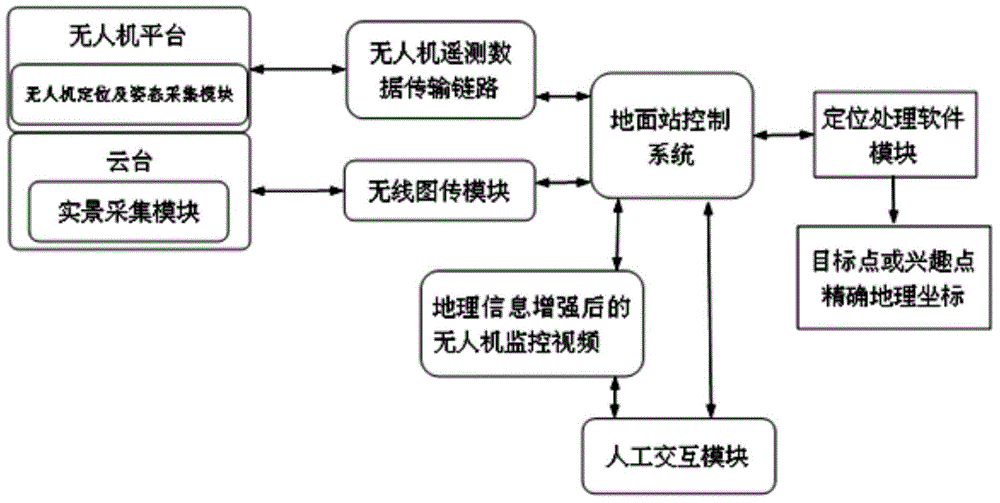
[0045] Such as figure 1 As shown, the present invention provides a UAV ground target positioning system based on enhanced geographic information, including: UAV on-board system, data transmission module and ground station control system; The module exchanges information with the ground station control system;

[0046] Wherein, the on-board system of the UAV includes a real scene acquisition module, a GPS positioning module and an attitude acquisition module;

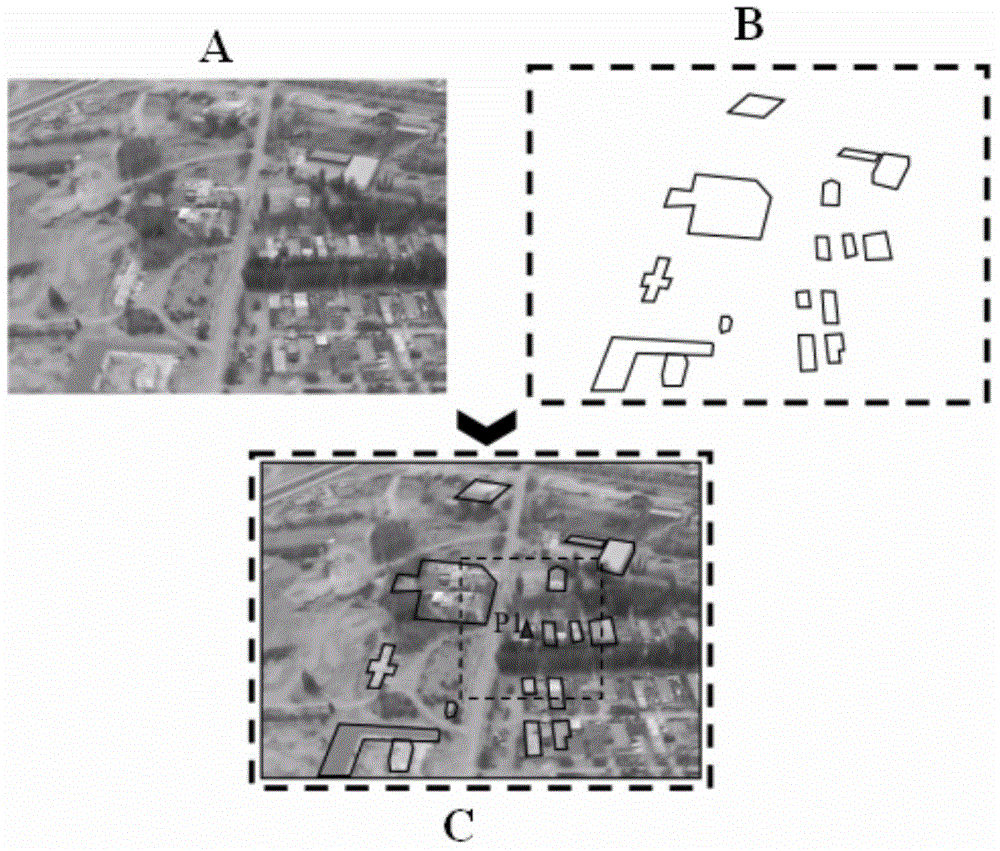
[0047] The real-scene acquisition module is mounted on the pan-tilt of the drone, wherein the pan-tilt can adopt a three-axis stabilized pan-tilt, which has the functions of self-attitude measurement and three-axis orientation control. Through the real scene acquisition module, collect the real scene image of the locked target area, such as figure 2As shown, the symbol A is an example of a real-scene image; here, it ...


PUM


Abstract

The invention provides a system and a method for positioning ground targets of unmanned planes based on enhanced geographic information. The system comprises an unmanned onboard system, a data transmission module and a ground station control system, wherein the unmanned plane onboard system is used for interacting information with the ground station control system by virtue of the data transmission module; the unmanned onboard system comprises a real scene collecting module, a GPS positioning module and a posture collecting module; the ground station control system comprises an electronic map database, a projection module, a positioning module and a traversal module. The system and the method have the advantages that positioning values of target points can be obtained by only matching real scene images with a three-dimensional map without the need of the complex image processing algorithm by virtue of a simple fitting method. Therefore, the ground scene targets in the large range can be accurately positioned; since the positioning algorithm is simple, the positioning rate is high; the requirements of tracking the targets in real time can be met.

Description

technical field [0001] The invention belongs to the technical field of space positioning, and in particular relates to a ground target positioning system and method for an unmanned aerial vehicle based on enhanced geographic information. Background technique [0002] The remote tracking and monitoring of targets using the video system carried by drones is an important content in the field of drone applications. At present, the main method is: the ground control station receives the video image returned by the UAV system; and then, uses a specific image processing algorithm to extract and recognize the target in the video. However, due to the complex background of the video image, on the one hand, the existing image processing algorithm is complex, which reduces the speed of target positioning; on the other hand, the existing target positioning accuracy is limited. Some target positioning accuracy can no longer meet the demand. Contents of the invention [0003] Aiming at...

Claims


Application Information

Patent Timeline
Patent Type & Authority Applications(China)
IPC IPC(8): G01C11/00
CPCG01C11/00
Inventor 孙敏姜城黎晓东刘磊郑晖
Owner PEKING UNIV
Why Eureka
Try Eureka