Detailed map construction method and device

A fine, map-based technology, applied to maps/plans/charts, instruments, road network navigators, etc., can solve problems such as the inability to establish multi-dimensional spatial road networks and high error rates in geometric topology, to reduce dependencies, improve accuracy, and reduce Effects of error and error rate

Active Publication Date: 2015-04-29
NAVINFO
View PDF8 Cites 12 Cited by
  • Summary
  • Abstract
  • Description
  • Claims
  • Application Information

AI Technical Summary

Problems solved by technology

[0010] The technical problem to be solved by the present invention is to provide a method and device for constructing a fine map, which solves the problem that the geometric topology error rate is high and the multi-dimensional space road network cannot be established in the existing map making

Method used


Image

  • Detailed map construction method and device
  • Detailed map construction method and device
  • Detailed map construction method and device

Examples


Embodiment Construction

[0027] In order to make the technical problems, technical solutions and advantages to be solved by the present invention clearer, the following will describe in detail with reference to the drawings and specific embodiments.

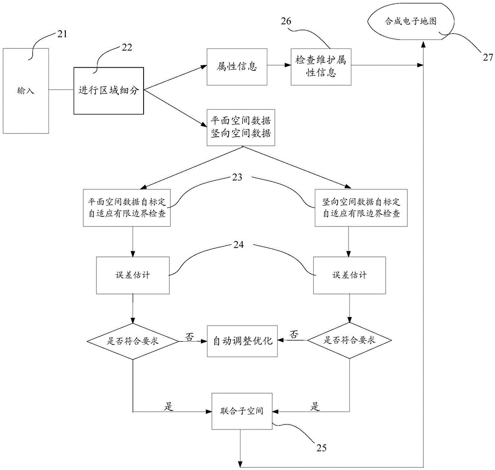
[0028] In the present invention, self-adaptive finite boundary checks are performed on spatial graphics during the drawing process to eliminate topological errors, and a multi-dimensional three-dimensional road network is established based on joint subspaces and synthetic vector topology checks of plane traffic and vertical traffic.

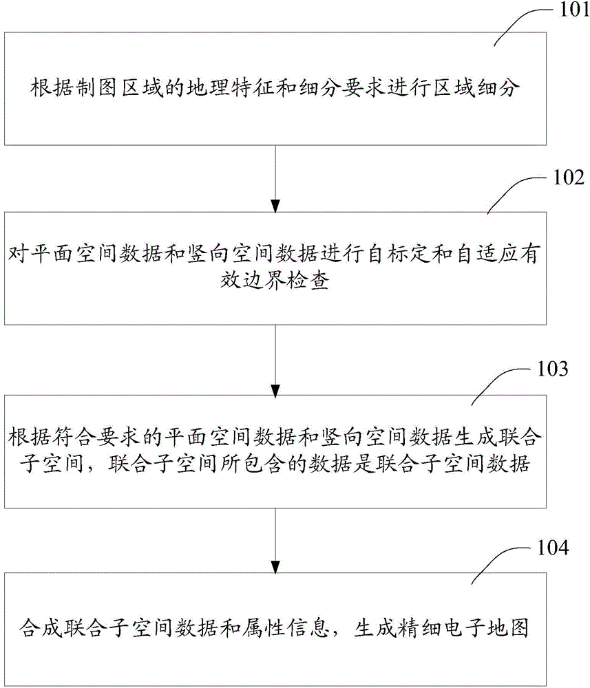
[0029] An embodiment of the present invention provides a method for constructing a fine map, such as figure 1 shown, including:

[0030] Step 101, performing regional subdivision according to the geographic features and subdivision requirements of the mapping region;

[0031] Step 102, performing self-calibration and self-adaptive valid boundary check on the planar spatial data and the vertical spatial data;

[0032] Step...


PUM


Abstract

The embodiment of the invention provides a detailed map construction method and a detailed map construction device. The method comprises the following steps: performing area subdivision according to the geographic features of the map land and the subdivision requirements; performing self-calibration and self-adaption effective boundary checking to plane spatial data and vertical spatial data; generating united subspaces according to the plane spatial data and the vertical spatial data meeting the requirements, wherein data contained in the united subspaces are united subspace data; combining the united subspace data and attribute information to generate the detailed electronic map. The area subdivision is performed to reduce the dependency of the local data to the whole data; the self-calibration and self-adaption effective boundary checking are performed, the united subspaces are generated according to the plane spatial data and the vertical spatial data meeting the requirements, and in the process the self-adaption vector compositing method is fully utilized, so that the error and the error rate of the geometric topology in the manufacturing process can be reduced, and the precision of the electronic map can be improved.

Description

technical field [0001] The invention relates to electronic map technology, in particular to a method and device for constructing fine maps. Background technique [0002] As a kind of electronic map, fine map includes spatial vector data and attribute information, and spatial vector data is the carrier of electronic map attribute information. The traditional method of making electronic maps is to use the method of abstractly extracting space vector data based on raster data or use GPS, robot positioning and tracking devices to record and collect the spatial position and field of view information of the area passed by, and process and produce space vector data, including: [0003] 1. Using Bayesian or self-organizing maps to identify grid patterns, grid maps can record the characteristics of environmental probability changes near vector features, abstract and extract space vector data, and thus obtain the structure of abstract environments and objects. [0004] 2. The improve...

Claims


Application Information

Patent Timeline
Patent Type & Authority Applications(China)
IPC IPC(8): G01C21/32G09B29/00
CPCG01C21/32G09B29/005
Inventor 杜宇程赵方方刘永恒
Owner NAVINFO
Why Eureka
Try Eureka