Indoor navigation system and indoor navigation method thereof

An indoor navigation and indoor scene technology, applied in the indoor navigation system and its indoor navigation field, can solve the problems of high design cost, recognition failure, high investment cost, etc., and achieve the effect of easy implementation, getting rid of difficulties and low cost.

Active Publication Date: 2013-09-11
深圳橙立科技有限公司
View PDF4 Cites 66 Cited by
  • Summary
  • Abstract
  • Description
  • Claims
  • Application Information

AI Technical Summary

Problems solved by technology

At present, the known outdoor navigation (such as GPS) technology has matured, because GPS (Global Positioning System, Global Positioning System) cannot work normally indoors, so GPS technology cannot be effectively used indoors
So far, the indoor navigation system developed by ESA through accelerometers, gyroscope sensors, local wireless local area networks and computer data models of related buildings is not portable enough, the investment cost is high, and it is not popular and convenient; for Google Maps , 70% of positioning services are realized through Wi-Fi (a technology that can wirelessly connect personal computers, handheld devices and other terminals to each other) positioning, but due to the influence of Wi-Fi factors on the accuracy of positioning, it needs to be improved; There is a Chinese patent with the patent number "CN101984643A", which discloses "a mobile terminal with indoor navigation function and an indoor navigation method". The three-dimensional position information of the terminal in the room realizes indoor three-dimensional navigation, but with the height of the floor, changes in atmospheric pressure will affect the accuracy of navigation; RFID (Radio Frequency Identification, radio frequency identification) technology is a combination of antennas, tags and readers To identify data, but the design cost is high, and it is susceptible to the influence of metal materials, water and other substances, resulting in identification failure or identification error; Near Field Communication (NFC) can achieve a range of 10 cm through the combination of chips, antennas and some software However, its data transmission rate is low, and the application equipment must have an NFC chip, so this method has certain limitations and has not been fully popularized; Baidu Maps has added an indoor map function, It can only display indoor plane information, and cannot provide users with more location services and navigation services
It can be seen that the application of outdoor positioning system and radio wave technology in indoor navigation will face the problem of navigation accuracy, and the error of outdoor navigation is unacceptable for indoor navigation applications; secondly, indoor navigation based on Wi-Fi hotspots and base stations The stability and accuracy of the system need to be improved;

Method used


Image

  • Indoor navigation system and indoor navigation method thereof

Examples


Embodiment Construction

[0027] Below in conjunction with accompanying drawing and specific embodiment the present invention is described in further detail:

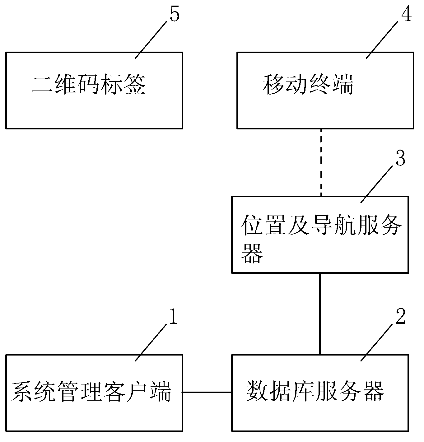
[0028] The indoor navigation system designed by the present invention includes a system management client 1, a location and navigation server 3, a mobile terminal 4, a two-dimensional code label 5 arranged on each navigation target position indoors, and a database server 2, wherein the two The two-dimensional code identification information of the two-dimensional code label 5 is bound to the target location information and stored in the database server 2, the system management client 1 is connected to the database server 2, the database server 2 is connected to the location and navigation server 3, and the location and navigation server 3. Wirelessly communicate with the mobile terminal 4, and the mobile terminal 4 can scan the two-dimensional code label 5 of each navigation target position.

[0029] In the above technical solution, the location...


PUM


Abstract

The invention discloses an indoor navigation system and an indoor navigation method thereof. The indoor navigation system comprises a system management client, a position and navigation server, a mobile terminal, a mobile terminal, two-dimension code labels arranged at various indoor navigation target positions, and a database server, wherein the two-dimension code identification information of the two-dimension code labels and the target position information are bound and stored in the database server; the system management client is connected with the database server; the database server is connected with the position and navigation server; the position and navigation server wirelessly in communication with the mobile terminal; the mobile terminal can scan the two-dimension code labels at various navigation target positions. The indoor positioning is realized based on the two-dimension codes, the problem that the indoor positioning is inaccurate in the prior art is solved, and the indoor positioning precision is improved; moreover, navigation is performed according to the guidance of color sequence, so that the reasonability and the universality of the indoor navigation system are improved.

Description

technical field [0001] The invention relates to the technical field of navigation, in particular to an indoor navigation system and an indoor navigation method thereof. Background technique [0002] With the rapid development of modern communication technology and wireless network, more and more occasions require location-based services, and people's demand for positioning and navigation is increasing. At present, the known outdoor navigation (such as GPS) technology has matured, because the GPS (Global Positioning System, Global Positioning System) cannot work normally indoors, so the GPS technology cannot be effectively used indoors. So far, the indoor navigation system developed by ESA through accelerometers, gyroscope sensors, local wireless local area networks and computer data models of related buildings is not portable enough, the investment cost is high, and it is not popular and convenient; for Google Maps , 70% of positioning services are realized through Wi-Fi (a...

Claims


Application Information

Patent Timeline
Patent Type & Authority Applications(China)
IPC IPC(8): G01C21/00
Inventor 郭羽成曹蕾
Owner 深圳橙立科技有限公司
Why Eureka
Try Eureka