Integrated navigation system applied to pilotless aircraft

An integrated navigation system, unmanned aerial vehicle technology, applied in the field of navigation, can solve the problem that the method cannot be used alone

Inactive Publication Date: 2009-12-09
BEIHANG UNIV
View PDF0 Cites 66 Cited by
  • Summary
  • Abstract
  • Description
  • Claims
  • Application Information

AI Technical Summary

Problems solved by technology

However, due to the principle limitation of this method, there are multiple solutions when solving its own position, and another navigation method is requir

Method used


Image

  • Integrated navigation system applied to pilotless aircraft
  • Integrated navigation system applied to pilotless aircraft
  • Integrated navigation system applied to pilotless aircraft

Examples


Embodiment Construction

[0035] The present invention will be further described in detail with reference to the accompanying drawings and embodiments.

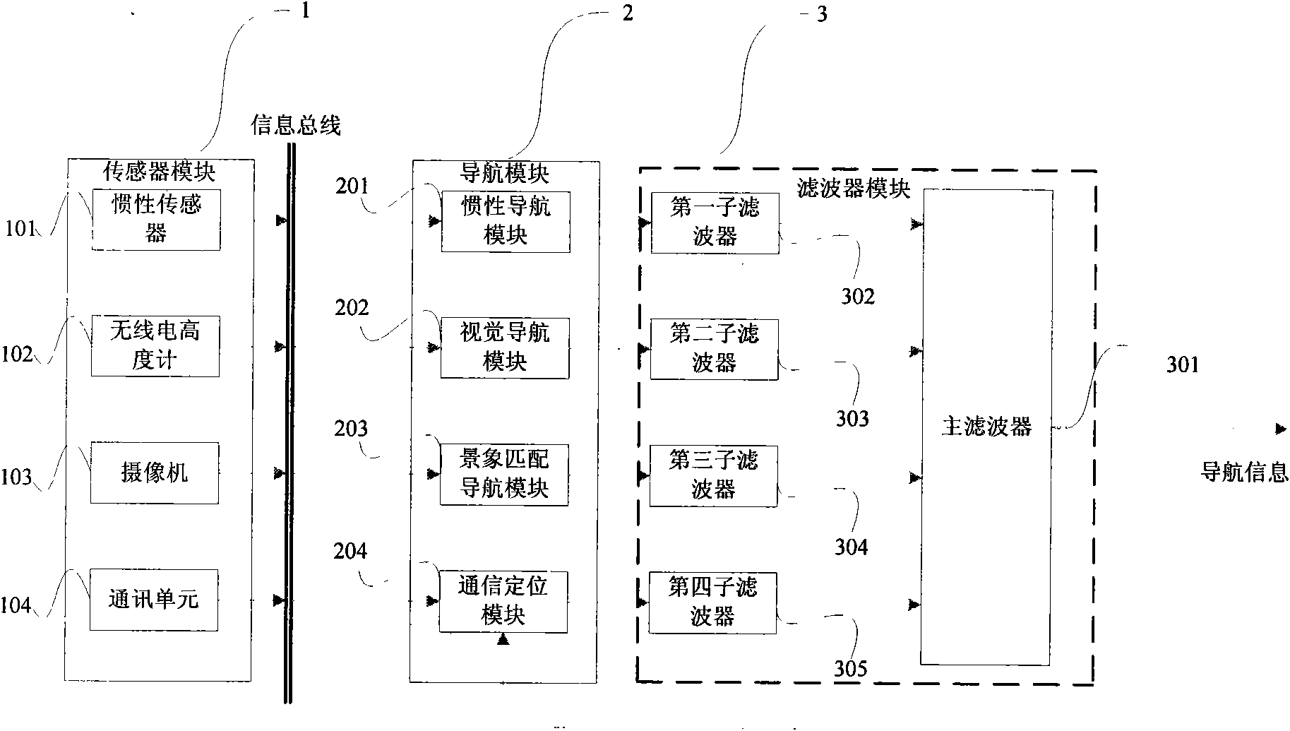
[0036] The invention mainly includes a sensor module, a navigation module and a filter module.

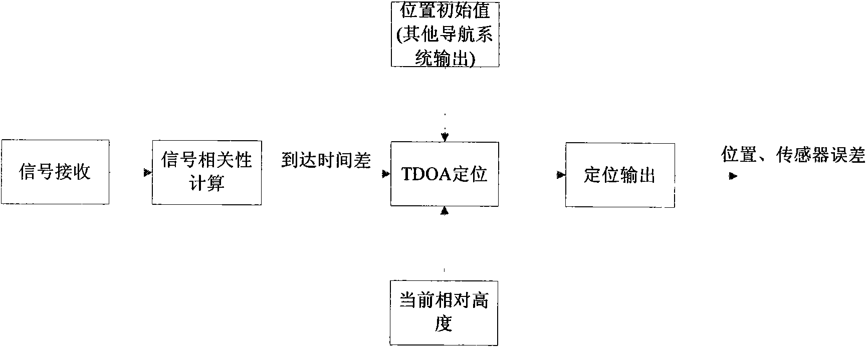
[0037] Such as figure 1 As shown, the sensor module 1 obtains the necessary acceleration, angular velocity, relative altitude, down-view image, and cellular network signal for aircraft navigation; the navigation module 2 performs navigation calculation on the signal obtained by the sensor module 1, and each part outputs the signal including the error The navigation calculation result of the navigation module 3 is used to fuse the output information of the navigation module 2 to obtain a relatively accurate aircraft state estimation, including: aircraft position, velocity, attitude and sensor error.

[0038] The sensor module 1 includes an inertial sensor 101, a radio altimeter 102, a camera 103, a communication module 104, etc., wherein the inertial senso...


PUM


Abstract

The invention discloses an integrated navigation system applied to a pilotless aircraft, which adopts a sensor comprising an inertial sensor, a radio altimeter, a communication module, a camera and the like, wherein the inertial sensor is used for acquiring motion acceleration and angular velocity of a carrier, and providing the motion acceleration and the angular velocity for an inertial navigation system and a vision navigation system in the unknown environment for setting up a system equation, thus further providing the current location information and matched trigger signals for scene matching navigation. The method integrates four combination ways which are inertial navigation, cellular wireless location navigation, vision navigation in the unknown environment and the scene matching navigation, and the four combination ways form each subsystem of the integrated navigation system and can be independently used for estimating the state of the aircraft; then, fault diagnosis and fusion estimation are carried out on the data output by the subsystems by a main filter, so that the accurate estimation of the state of the aircraft is obtained.

Description

technical field [0001] The invention relates to the field of navigation, in particular to an integrated navigation system applied to unmanned aircraft. Background technique [0002] UAV (Unmanned Aerial Vehicle, abbreviated as UAV) is the abbreviation of unmanned aerial vehicle. Compared with manned aircraft, it has the characteristics of small size, light weight, short run distance, low cost and good concealment. [0003] With the development of technology, the use of drones has expanded to a wide range of fields from military applications to scientific research. In terms of military affairs, drones have gradually replaced manned aircraft due to their powerful functions and low cost of use, and have been or will soon be widely used in the fields of reconnaissance and electronic support, electronic warfare, and air combat. The developed Predator unmanned reconnaissance aircraft and the "Global Hawk" (Global Hawk) high-altitude long-endurance unmanned reconnaissance aircraf...

Claims


Application Information

Patent Timeline
IPC IPC(8): G01C21/24
Inventor 范耀祖徐超沈晓蓉张海
Owner BEIHANG UNIV
Why Eureka
Try Eureka