Optical remote sensing satellite rigorous imaging geometrical model building method

An optical remote sensing and geometric model technology, applied in photogrammetry/video surveying, measuring devices, instruments, etc., can solve the problem of difficult to build a strict imaging geometric model of optical remote sensing satellites

Active Publication Date: 2015-07-08
SATELLITE SURVEYING & MAPPING APPL CENTSASMAC NAT ADMINISTATION OF SURVEYING MAPPING & GEOINFORMATION OF CHINANASG
View PDF5 Cites 29 Cited by
  • Summary
  • Abstract
  • Description
  • Claims
  • Application Information

AI Technical Summary

Problems solved by technology

In particular, it is difficult to construct a rigorous ...

Method used


Image

  • Optical remote sensing satellite rigorous imaging geometrical model building method
  • Optical remote sensing satellite rigorous imaging geometrical model building method
  • Optical remote sensing satellite rigorous imaging geometrical model building method

Examples


Embodiment Construction

[0010] In order to make the object, technical solution and advantages of the present invention clearer, the present invention will be described in further detail below in conjunction with specific embodiments and with reference to the accompanying drawings.

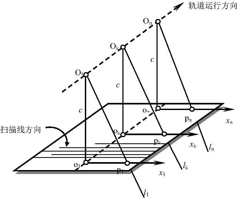
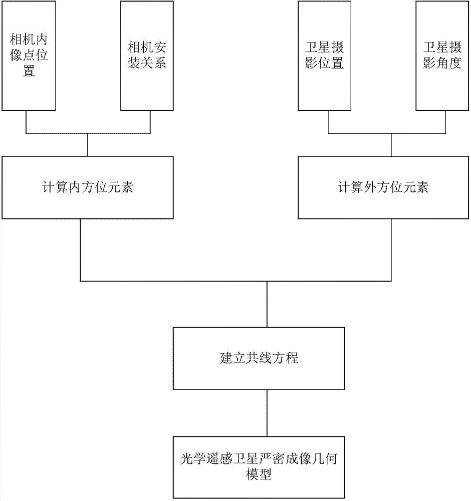
[0011] image 3 It is a schematic diagram of the construction principle of the rigorous imaging geometric model of the optical remote sensing satellite according to the present invention. like image 3 As shown, the inner orientation element is calculated by obtaining the internal image point position of the optical remote sensing satellite camera and the camera installation relationship, and the outer orientation element is calculated by obtaining the photographic position and angle of the optical remote sensing satellite camera, and the calculated inner orientation element and outer orientation are used Elements are used to establish collinear equations, and thus the rigorous imaging geometric model of optical remote s...


PUM


Abstract

The invention provides an optical remote sensing satellite rigorous imaging geometrical model building method. The optical remote sensing satellite rigorous imaging geometrical model building method comprises the following steps that the geometrical relationship between the image point coordinates of an optical remote sensing satellite and the satellite is determined according to design parameters and on-orbit calibration parameters of an optical remote sensing satellite camera and the installation relation of the camera and the satellite; the shooting position of a satellite image is determined according to the GPS carried by the optical remote sensing satellite, the observation data of a laser corner reflector and the installation relation of the laser corner reflector and the satellite; the shooting angle of the satellite image is determined according to a star sensor carried by the optical remote sensing satellite and the observation data of a gyroscope and the installation relation of the gyroscope and the optical remote sensing satellite, a collinearity equation of all image points of the optical remote sensing satellite is built, and a rigorous imaging geometrical model of optical remote sensing satellite images is formed. The optical remote sensing satellite rigorous imaging geometrical model building method is the basis of optical remote sensing satellite follow-up geometrical imaging processing and application.

Description

technical field [0001] The invention belongs to the technical field of photographic imaging measurement, in particular to a method for constructing a precise imaging geometric model of an optical remote sensing satellite. Background technique [0002] In photogrammetry technology, the rigorous imaging geometric model is closely related to the sensor, and different imaging models are required for different types of sensors. With the emergence of various new aviation and aerospace sensors, from an application point of view, in order to process the data of these new sensors, users need to change their software or add new sensor imaging models to their systems, which brings many problems to users. inconvenient. In addition, rigorous imaging models are not always available because their establishment requires knowledge of sensor physics and imaging mechanisms of airborne and aerospace sensor images. In particular, it is difficult to construct a rigorous imaging geometric model ...

Claims


Application Information

Patent Timeline
IPC IPC(8): G01C11/00
CPCG01C11/00
Inventor 唐新明祝小勇付兴科高小明谢俊峰周平
Owner SATELLITE SURVEYING & MAPPING APPL CENTSASMAC NAT ADMINISTATION OF SURVEYING MAPPING & GEOINFORMATION OF CHINANASG
Why Eureka
Try Eureka