Way-finding navigation method

A technology of navigation path and navigation information, applied in the field of wayfinding and navigation, which can solve problems such as inability to perform navigation operations, and achieve the effect of expanding the geographical scope

Inactive Publication Date: 2015-07-08
SICHUAN JIUZHOU ELECTRIC GROUP
View PDF6 Cites 8 Cited by
  • Summary
  • Abstract
  • Description
  • Claims
  • Application Information

AI Technical Summary

Problems solved by technology

Existing navigation systems cannot navigate when the user is moving in a blind spot on the map

Method used


Image

  • Way-finding navigation method

Examples


Embodiment Construction

[0043] The implementation of the present invention will be described in detail below in conjunction with the accompanying drawings and examples, so that implementers of the present invention can fully understand how the present invention uses technical means to solve technical problems, and achieve the realization process of technical effects and according to the above-mentioned realization process The present invention is implemented concretely. It should be noted that, as long as there is no conflict, each embodiment and each feature in each embodiment of the present invention can be combined with each other, and the formed technical solutions are all within the protection scope of the present invention.

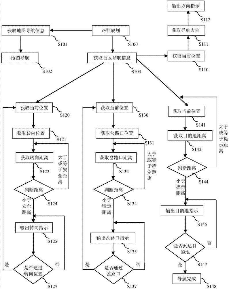
[0044] Aiming at the current problem that wayfinding and navigation cannot be realized in the blind area of ​​the map without an electronic path, the present invention proposes a wayfinding and navigation method. Next, the implementation process of the wayfinding and navig...


PUM


Abstract

The invention discloses a way-finding navigation method, which comprises the following steps: A)a path programming step: a navigation starting position and a navigation ending position can be obtained according to the user navigation requirement, and a navigation path is obtained according to the navigation starting position and the navigation ending position, the navigation path comprises a blind area road positioned in a map blind area; B)a navigation information obtaining step: the navigation information corresponding to the navigation path is obtained, the navigation information comprises the blind area navigation information; and C)a navigation step, navigation is carried out based on the navigation information, wherein, when the user moves to the map blind area, the navigation indication is generated based on the blind area navigation information, so that the user can be guided to move along the blind area road. According to the invention, automatic navigation is realized in the map blind area of an electronic map based on the way-finding navigation method, so that region scope used by navigator can be greatly expanded.

Description

technical field [0001] The invention relates to the field of navigation, in particular to a wayfinding and navigation method. Background technique [0002] Currently, most of the navigation systems on the market are based on electronic maps and use the Global Positioning System (GPS) for navigation. By comparing the detected latitude and longitude of the current location with the latitude and longitude of the electronic map, the current position is displayed, and then the current position and the input terminal position are used to search for the route in the electronic map to plan the best route. In the process of moving, it constantly compares the positioning information with the information of the electronic map route, so as to play the role of navigation. [0003] It is not difficult to understand that the premise of implementing the above conventional navigation methods is that there is corresponding navigation information in the electronic map, such as map routes corr...

Claims


Application Information

Patent Timeline
Patent Type & Authority Applications(China)
IPC IPC(8): G01C21/00G01C21/26
CPCG01C21/00G01C21/26
Inventor 唐士林熊飞
Owner SICHUAN JIUZHOU ELECTRIC GROUP
Why Eureka
Try Eureka