Low-altitude flight target warning system and low-altitude flight target warning method based on Beidou satellite navigation system

A technology for flight targets and navigation systems, applied in satellite radio beacon positioning systems, traffic control systems, radio wave measurement systems, etc., can solve problems such as insufficient consideration of indirect safety hazards, safety flight accidents, and insufficient monitoring, etc., to achieve The warning information is timely and accurate, and the effect of improving flight safety

Active Publication Date: 2015-08-19
XIAN SHANNON SOFTWARE TECH CO LTD
View PDF6 Cites 22 Cited by
  • Summary
  • Abstract
  • Description
  • Claims
  • Application Information

AI Technical Summary

Problems solved by technology

Generally speaking, there are two deficiencies in the monitoring systems currently on the market: one is that monitoring is carried out in two-dimensional maps, which is not sufficient for the monitoring of movements in three-dimensional spaces such as aircraft; the other is that the system functions are relatively single, mainly monitoring Target trajectory display and short-message communication are the main focus, lack of comprehensive judgment and real-time warning of the safety status of the monitoring target, and the safety warning of low-altitude flying targets only focuses on the warning of flight into the ground, while the situation of the air situation and the composition of terrain and landform Insufficient consideration of direct safety threats, as well as indirect safety hazards constituted by mission areas and flight path planning, leads to unsatisfactory auxiliary decision-making information, which easily leads to misjudgment and safety flight accidents

Method used


Image

  • Low-altitude flight target warning system and low-altitude flight target warning method based on Beidou satellite navigation system
  • Low-altitude flight target warning system and low-altitude flight target warning method based on Beidou satellite navigation system
  • Low-altitude flight target warning system and low-altitude flight target warning method based on Beidou satellite navigation system

Examples


Embodiment Construction

[0084] The present invention will be further described in detail below in conjunction with specific embodiments, which are explanations of the present invention rather than limitations.

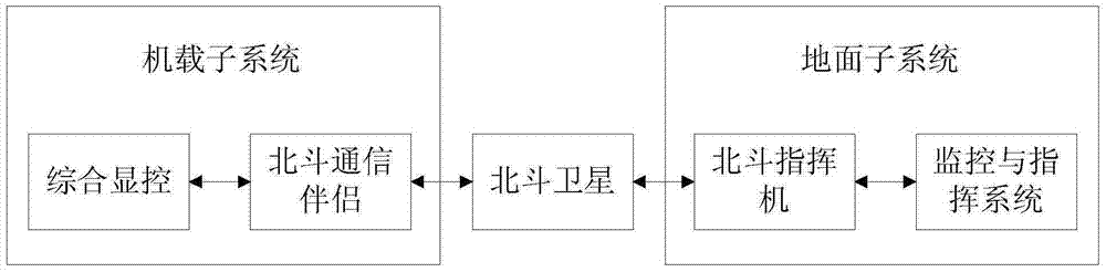
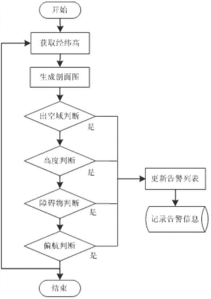
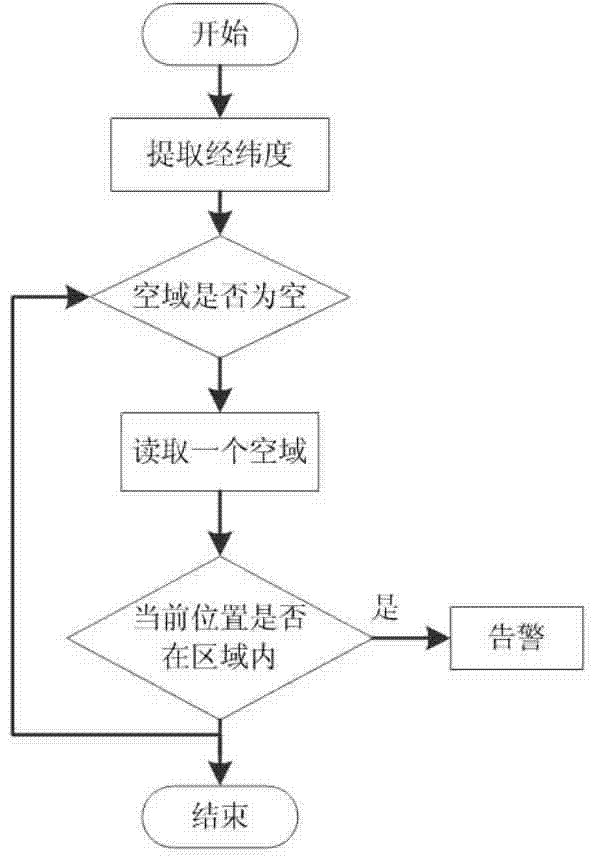
[0085] The present invention is based on the low-altitude flying target warning method of the Beidou satellite navigation system. The overall process is as figure 2 As shown, by setting the alarm information list lstAlert, all kinds of alarm information can be dynamically maintained, and non-repetitive records can be displayed and stored in time. Cooperate with the clock function to maintain the alarm information list lstAlert in real time; realize the following functions, 1. Real-time processing of various information during the flight, including real-time air conditions, geographical location, flight time, airspace conditions and other information; 2. Determine whether there is a safety hazard Threats, including entering dangerous airspace, flying out of mission airspace, flying too low, ...


PUM


Abstract

The invention provides a comprehensive flight safety warning system and a comprehensive flight safety warning method, which can be used for performing safety monitoring and command guide on a low-altitude flight target, performing threat comprehensive estimation and real-time warning, based on a Beidou satellite navigation system. By adopting the Beidou satellite navigation system, not only can three-dimensional positioning information of a flight target be provided, but also the flight parameters can be transmitted, so that a good technical supporting platform is provided for realizing comprehensive warning application. On the premise of comprehensively analyzing various security threats, real-time safety warning is realized on the low-altitude flight target; for direct safety threat warning, not only is most-concerned course front height warning in the flight track reflected, but also terrain perception, threat estimation and safety warning are performed at the left and the right sides of the flight object through a barrier warning method, so that the barrier perception and warning system around the flight target is perfected. Through the realization of the barrier warning method, a safe navigation track is planned, and the safety of the whole flight pipeline is further ensured.

Description

technical field [0001] The invention relates to the technical field of communication, in particular to a low-altitude flying target warning system and method based on the Beidou satellite navigation system. Background technique [0002] In the field of aviation, the flight process is divided into ultra-low-altitude flight, low-altitude flight, medium-altitude flight, high-altitude flight and ultra-high-altitude flight according to the flight height, as shown in the table below. [0003] [0004] Low-altitude flight usually refers to the flight from 100m to 1000m from the ground or water surface. Whether it is in military applications or civilian applications, low-altitude flight is very common. For example, in the military field, the parachute of armed helicopters, equipment airdrops, armed reconnaissance, fighter jets' assault, penetration assault, etc.; important role. Due to the low flying altitude of the aircraft, low-altitude flight can reduce the detection rate of...

Claims


Application Information

Patent Timeline
Patent Type & Authority Applications(China)
IPC IPC(8): G08G5/00G01S19/39
CPCG01S19/39G08G5/006G08G5/0086G08G5/045
Inventor 拓明福李宗哲张军白洋
Owner XIAN SHANNON SOFTWARE TECH CO LTD
Why Eureka
Try Eureka