Supercharge Your Innovation With Domain-Expert AI Agents!

A satellite positioning integrity detection device and its algorithm

A technology of satellite positioning and integrity, applied in satellite radio beacon positioning systems, measuring devices, radio wave measuring systems, etc., can solve the problems of reduced number of satellite measurement values, large errors, and the inability of the receiver to give positioning results, etc. Achieve the effect of improving customer experience

Active Publication Date: 2018-02-23
杭州中科微电子有限公司
View PDF5 Cites 0 Cited by
  • Summary
  • Abstract
  • Description
  • Claims
  • Application Information

AI Technical Summary

Problems solved by technology

However, when the receiver enters an environment with severe attenuation and deformation of satellite signals (such as forest environment, dense urban areas, and canyon areas), the number of satellite measurement values ​​synthesized by the receiver will decrease, and there may be relatively large errors, which will cause the receiver to fail. The positioning result is given, or the calculated positioning result is inaccurate

Method used


Image

  • A satellite positioning integrity detection device and its algorithm
  • A satellite positioning integrity detection device and its algorithm

Examples


Embodiment Construction

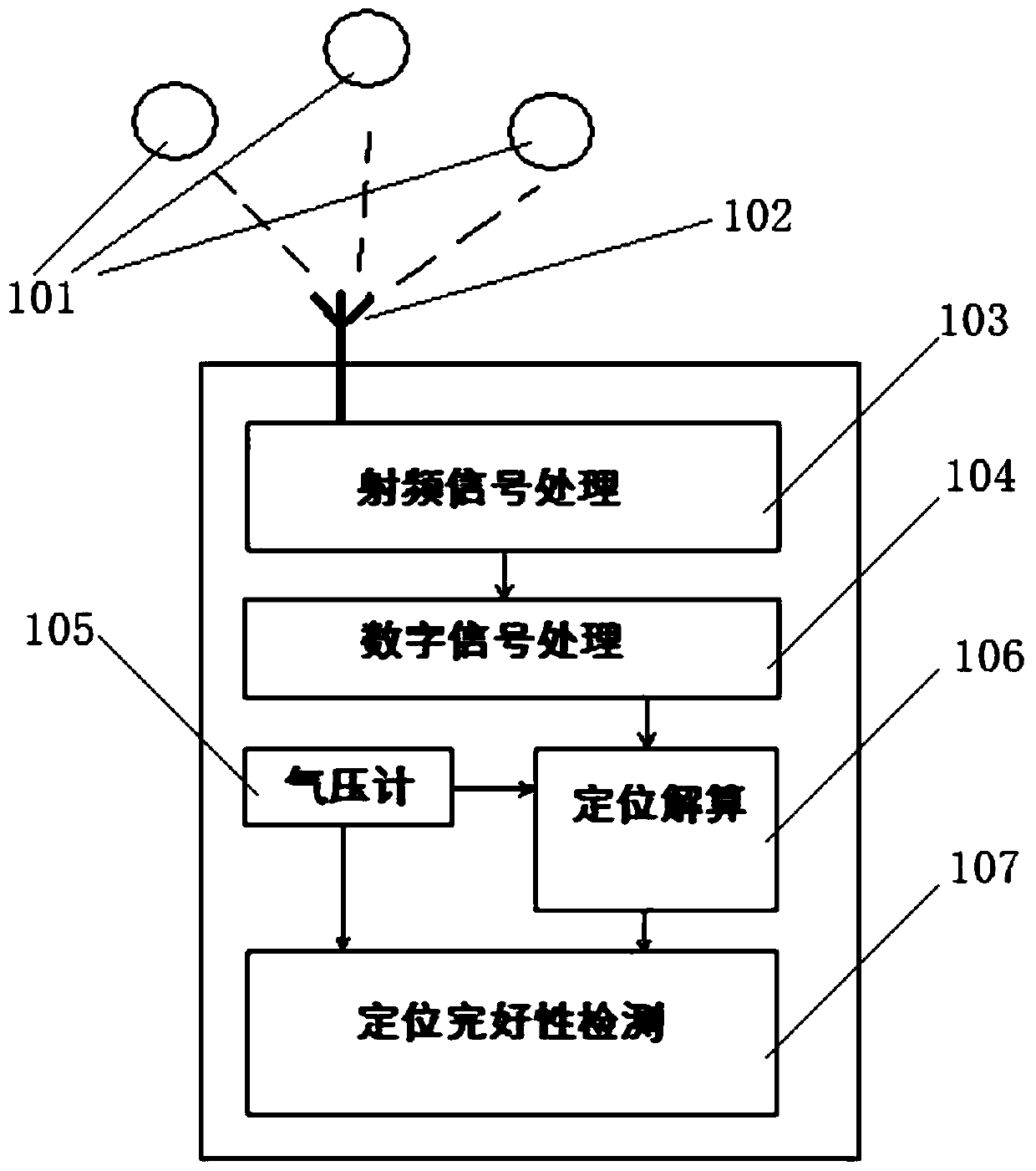
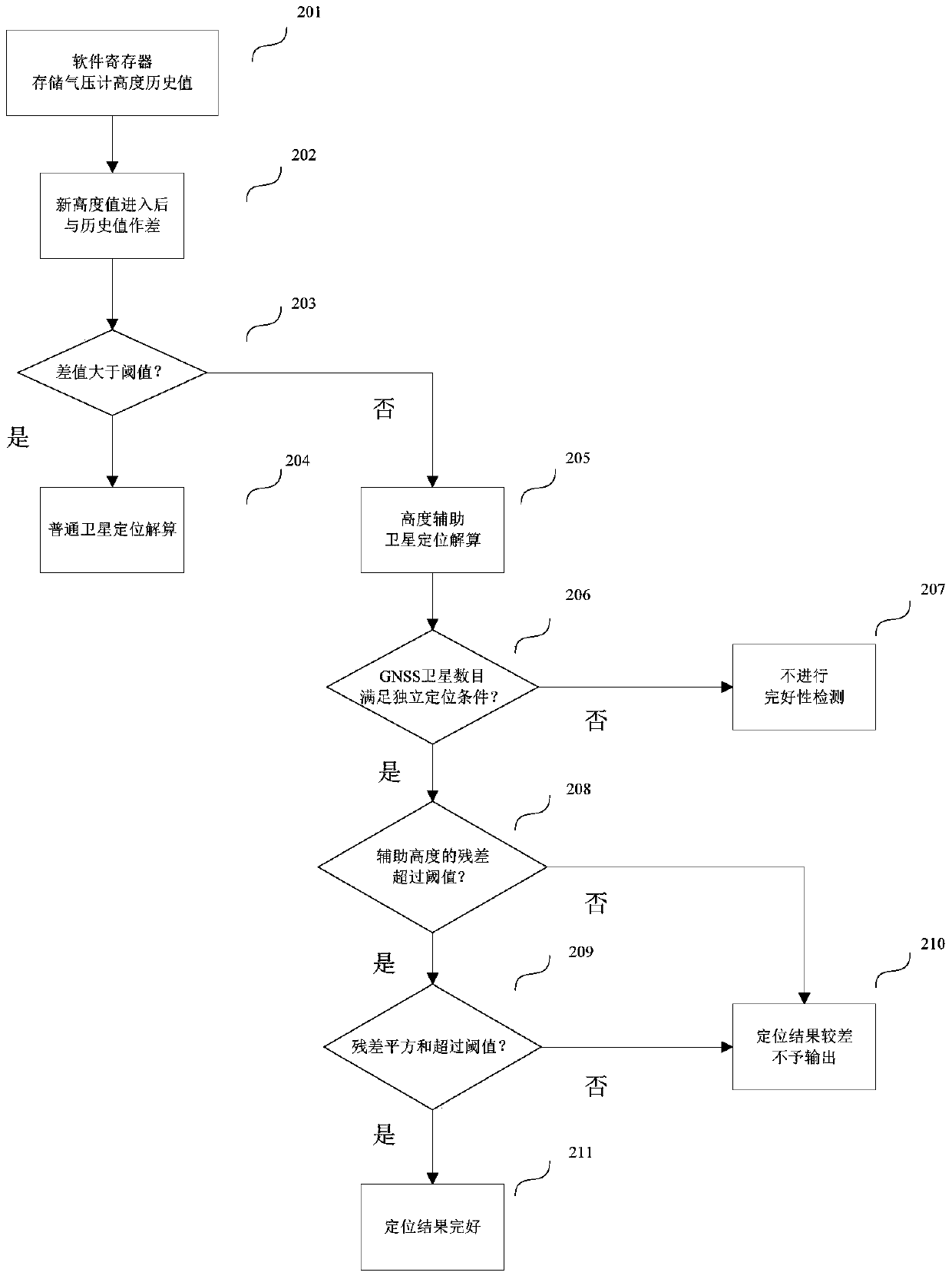
[0031] Such as figure 1 Shown is a schematic diagram of a GNSS navigation receiver integrated with a MEMS barometer device to achieve positioning. The GNSS receiver receives radio frequency signals from multiple GNSS satellite constellations 101 through the multi-mode antenna 102, and converts them into digital intermediate frequency signals that can be directly processed by a digital signal processor in the radio frequency processing module 103. The digital signal processing module 104 processes the digital intermediate frequency signal, captures and tracks the signals of each satellite, demodulates the navigation message and obtains the measurement value information of the satellite. The MEMS barometer 105 integrated in the GNSS receiver module works independently of the GNSS receiver, and provides current air pressure information to the receiver in real time.

[0032] The positioning calculation module 106 is responsible for processing the satellite measurement value and t...


PUM


Abstract

The invention discloses a satellite positioning integrity detection apparatus and algorithm thereof. The algorithm includes the steps of processing and caching measurement data output by a barometer, detecting the existence of abrupt change, directly entering into normal positioning calculation without using height assistance if no abrupt change, carrying out positioning calculation by adding an auxiliary height equation, calculating the residual error of the measured value of the auxiliary height equation after positioning calculation is completed and the quadratic sum of all residual errors of measured values, counting up the number of available satellites, carrying out the next detection step, only if the number of available satellites satisfies the independent positioning requirement, and comparing the residual error of the measured value of the auxiliary height equation and the quadratic sum of all residual errors of the measured values with corresponding thresholds to determine the positioning integrity. In this way, a receiver can determine the validity of positioning results with the presence of auxiliary height information, thereby restricting error positioning output.

Description

technical field [0001] The invention relates to a GNSS combined positioning technology, relates to a MEMS sensor-assisted GNSS navigation algorithm, and in particular to a satellite positioning integrity detection device and an algorithm thereof. Background technique [0002] The Global Navigation Satellite System (GNSS) receivers currently on the market can provide good positioning results in most terrestrial environments. However, when the receiver enters an environment with severe attenuation and deformation of satellite signals (such as forest environment, dense urban areas, and canyon areas), the number of satellite measurement values ​​synthesized by the receiver will decrease, and there may be relatively large errors, which will cause the receiver to fail. The positioning result is given, or the calculated positioning result is inaccurate. In order to ensure that the receiver can still have good positioning accuracy in the case of poor satellite signal conditions, ME...

Claims


Application Information

Patent Timeline
Patent Type & Authority Patents(China)
IPC IPC(8): G01S19/23
CPCG01S19/23
Inventor 王浩何文涛蔺晓龙殷明翟昆明胡晓峰
Owner 杭州中科微电子有限公司
Features
  • R&D
  • Intellectual Property
  • Life Sciences
  • Materials
  • Tech Scout
  • Unparalleled Data Quality
  • Higher Quality Content
  • 60% Fewer Hallucinations
Learn More