Estimation method of surface temperature and emitted long-wave radiation under cloud in optical remote sensing images

An optical remote sensing image, surface temperature technology, applied in the direction of physical/chemical changes in thermometers, thermometers, image enhancement, etc., can solve problems such as inability to determine surface temperature, and achieve the effect of realizing surface temperature and recovery

Active Publication Date: 2018-03-09
INST OF REMOTE SENSING & DIGITAL EARTH CHINESE ACADEMY OF SCI
View PDF2 Cites 0 Cited by
  • Summary
  • Abstract
  • Description
  • Claims
  • Application Information

AI Technical Summary

Problems solved by technology

[0005] The main purpose of the present invention is to provide a method for estimating the ground surface temperature under the cloud of an optical remote sensing image and the emission of long-wave radiation, so as to solve the problem in the prior art that the ground surface temperature under cloudy conditions cannot be determined from the optical remote sensing image

Method used


Image

  • Estimation method of surface temperature and emitted long-wave radiation under cloud in optical remote sensing images
  • Estimation method of surface temperature and emitted long-wave radiation under cloud in optical remote sensing images
  • Estimation method of surface temperature and emitted long-wave radiation under cloud in optical remote sensing images

Examples


Embodiment 1

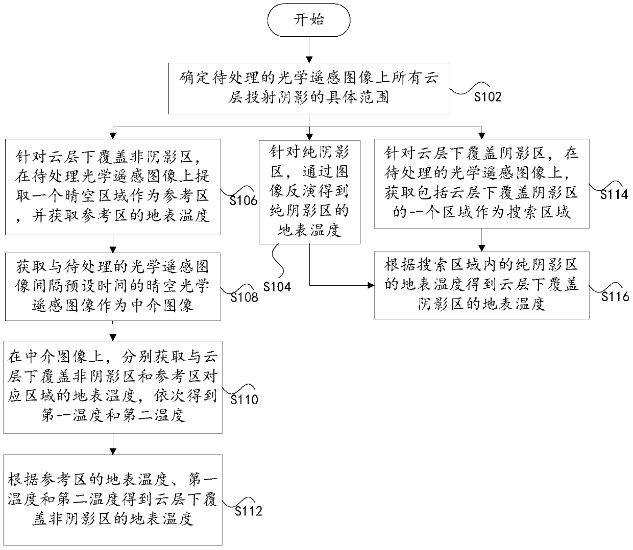
[0021] Embodiment 1 of the present invention provides a method for estimating the surface temperature under the cloud of an optical remote sensing image, see figure 1 , the method may include the following steps:

[0022] Step S102: Determine the specific range of shadows cast by all clouds on the optical remote sensing image to be processed.

[0023] Among them, when implementing this step, first use the corresponding relationship between the cloud layer and the shadow cast by the cloud layer on the optical remote sensing image to be processed, combine the satellite observation angle and the sun angle to determine the height of the cloud layer, and then determine the height of the cloud layer according to the height of the cloud layer and the optical remote sensing image to be processed , determine the specific range of shadows cast by all clouds on the optical remote sensing image to be processed, and the specific range includes pure shadow areas, non-shadowed areas covered ...

Embodiment 2

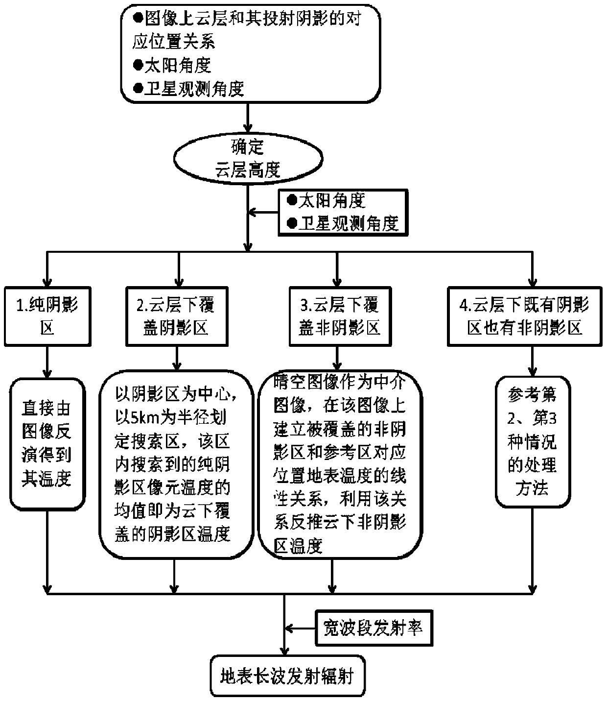
[0037] This embodiment is a further preferred method for estimating the surface temperature under the cloud of optical remote sensing images on the basis of Embodiment 1, see figure 2 , the method is specifically described as follows:

[0038] (1) Utilize the corresponding relationship between the cloud layer and its cast shadow on the image to be processed, and combine the satellite observation angle and the sun angle to determine the height of the cloud layer. Specifically: the distance between clouds and shadows can be directly obtained on the image, and the angle between the satellite and the sun can also be obtained directly in the auxiliary file of the satellite image. According to trigonometric functions, the given length and angle can be obtained by using the sine or cosine function high.

[0039](2) According to the cloud height and the observation angle of the sun and satellite, determine the specific range of shadows cast by all clouds on the image, specifically: ...

Embodiment 3

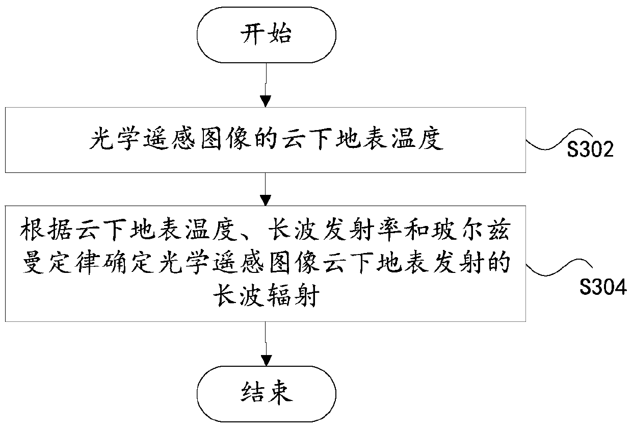
[0049] Embodiment 3 of the present invention provides a method for estimating the long-wave radiation emitted by the ground surface under the cloud of an optical remote sensing image, see image 3 , the method may include the following steps:

[0050] Step S302: the surface temperature under the cloud of the optical remote sensing image.


PUM


Abstract

The invention discloses a method for estimating the temperature of the ground surface under the cloud of an optical remote sensing image and emitting long-wave radiation. The method for estimating the surface temperature under the cloud of the optical remote sensing image includes: determining the specific range of shadows cast by all clouds on the optical remote sensing image to be processed, and obtaining the surface temperature of the pure shadow area through image inversion for the pure shadow area; In the non-shaded area, select the clear sky image with a preset time interval from the image to be processed as an intermediary image, determine a reference area on the optical remote sensing image to be processed, and obtain the surface temperature of the cloud covering the non-shaded area according to the temperature of the reference area; Aiming at the shadow area under the cloud cover, determine a search area on the optical remote sensing image to be processed; obtain the surface temperature of the shadow area under the cloud cover according to the surface temperature of the pure shadow area in the search area, thus realizing the surface temperature under the cloud cover estimate. Through the invention, the estimation of the surface temperature under the condition of cloud layer can be realized.

Description

technical field [0001] The invention relates to the technical field of environmental monitoring, in particular to a method for estimating the ground surface temperature under clouds and emitted long-wave radiation in optical remote sensing images. Background technique [0002] The use of optical remote sensing images to obtain land surface temperature is one of the key areas of remote sensing applications. The remote sensing retrieval of land surface temperature mainly relies on thermal infrared bands. However, it is difficult for thermal infrared bands to penetrate clouds. Under clear sky conditions, the surface temperature under cloudy conditions cannot be directly obtained from optical remote sensing images, resulting in discontinuous spatial distribution of temperature products retrieved by remote sensing, which is difficult to apply, for example, it is difficult to be adopted by models that study global change and it is difficult to accurately describe the surface temper...

Claims


Application Information

Patent Timeline
Patent Type & Authority Patents(China)
IPC IPC(8): G06K9/00G06T7/00G01K11/30
CPCG06T7/0002G01K11/30G06T2207/10032G06T2207/30181G06V20/194G06V20/13
Inventor 王天星施建成阎广建
Owner INST OF REMOTE SENSING & DIGITAL EARTH CHINESE ACADEMY OF SCI
Why Eureka
Try Eureka