GIS-based intelligent monitoring method for land full life circle

A technology of full life cycle and life cycle, applied in the field of GIS-based intelligent supervision of land life cycle, can solve problems such as inflexibility, inability to verify and update layers in real time, and single representation mode

Active Publication Date: 2015-11-11
武汉市土地利用和城市空间规划研究中心
View PDF2 Cites 13 Cited by
  • Summary
  • Abstract
  • Description
  • Claims
  • Application Information

AI Technical Summary

Problems solved by technology

This feature is not conducive to the visual expression of flowing data, especially data that is updated frequently, and the expression method is relatively single and not flexible enough
Single information update technol

Method used


Image

  • GIS-based intelligent monitoring method for land full life circle
  • GIS-based intelligent monitoring method for land full life circle
  • GIS-based intelligent monitoring method for land full life circle

Examples


Embodiment

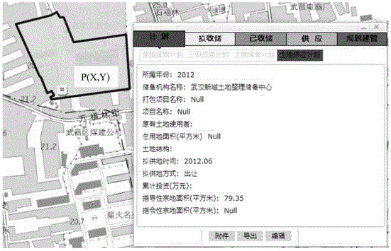
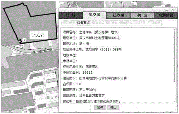
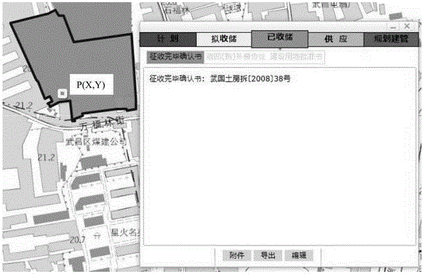
[0093] A specific implementation case of combining the above methods is introduced below.

[0094] (1) First, let's define the land life cycle implemented in the embodiment. In this embodiment, the layers of each stage of the land life cycle are stored in two remote databases, namely database 1 and database 2, both of which can be Reflect the current and historical conditions of each cycle stage, in which:

[0095] Database 1 contains 4 stages, database 2 contains 1 stage, there is a causal relationship between the layers contained in the 4 stages in database 1, and the layers contained in the 4 stages in database 1 and 1 stage in database 2 There is a causal relationship between the included layers, and there is a causal relationship between the layers included in 1 stage in database 2.

[0096] The layer data generated in each stage are automatically merged into this stage:

[0097] The whole life cycle of land is divided into five stages: A, B, C, D, and E, such as Figu...


PUM


Abstract

The invention relates to a GIS-based intelligent monitoring method for a land full life circle. The method comprises the steps that 1, a space position parameter determining module determines coordinates according to click positions; 2, a land full life circle model building module obtains layers contained in all stages, a topological relation between the layers and 1 is built, and latest and historical items are obtained according to the reverse chronological order; 3, an item information updating module builds the GIS topological relation according to the currency of 2 and completes initial updating; 4, an item information check module checks 3 according to a check rule module and the GIS topological relation; 5, an intelligent monitoring module automatically gives an early warm according to stage division rules and display rules, and updating is carried out according to 3 and 4. An item implementation schedule visible result obtained through the GIS-based intelligent monitoring method is obviously better compared with a land management service total factor life cycle model and a static state visible and single updating technology, dynamic correlation and real-time early warning can be carried out on different land utilization stages, and the intelligent monitoring purpose is achieved.

Description

technical field [0001] The invention relates to the technical field of land and planning information intelligent supervision, in particular to a GIS-based intelligent supervision method for the whole life cycle of land. Background technique [0002] Land is the material basis for the survival and development of human beings. In the process of its generation, change, and extinction, the spatial location and shape of land and its additional attribute information are constantly deduced and changed over time with the block as the basic unit, either quantitatively or qualitatively. The results are directly reflected in all stages of land life cycle management. Due to the different land management business processes in different regions, the content of land life cycle management is also inconsistent. Generally speaking, it mainly includes stages such as feasibility study project approval, land management "requisition and supplementary inspection and registration", planning manage...

Claims


Application Information

Patent Timeline
IPC IPC(8): G06Q10/06G06Q50/26
Inventor 陈韦黄焕张翼峰付雄武王长珍吴不为
Owner 武汉市土地利用和城市空间规划研究中心
Why Eureka
Try Eureka