Method for constructing high temporal-spatial remote sensing data

A remote sensing data, spatio-temporal technology, applied in image data processing, instrumentation, computing, etc., can solve the problems of pure pixels reducing the accuracy of fusion data, difficult to find, etc.

Inactive Publication Date: 2015-11-11
BEIJING NORMAL UNIVERSITY
View PDF1 Cites 39 Cited by
  • Summary
  • Abstract
  • Description
  • Claims
  • Application Information

AI Technical Summary

Problems solved by technology

[0004] The present invention aims at the problem that the STARFM model reduces the accuracy of the fusion data because it is difficult to search for pure pixels in the broken area. First, the pixel decomposition and downscaling algorithm is used to downscale the low-resolution data, and then the downscaled data is replaced in the STARFM algorithm. Directly resampled low-resolution data, and finally use the CDSTARFM algorithm combining the two for data fusion

Method used


Image

  • Method for constructing high temporal-spatial remote sensing data
  • Method for constructing high temporal-spatial remote sensing data
  • Method for constructing high temporal-spatial remote sensing data

Examples


Embodiment Construction

[0041] In order to make it easier for those skilled in the art to understand and implement the present invention, the present invention will be further described in detail below in conjunction with the accompanying drawings and specific embodiments.

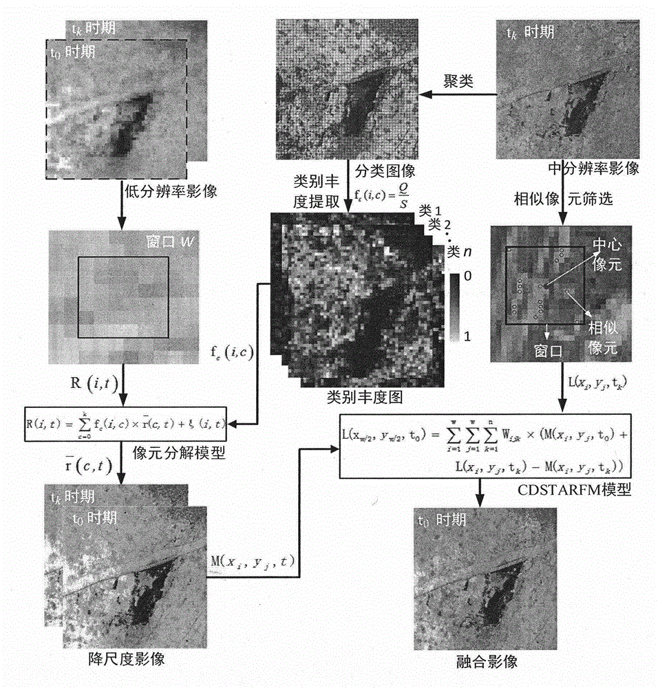
[0042] The invention combines the pixel decomposition downscaling algorithm and the CDSTARFM (CombiningDownscaleMixedPixelwithSpatialandTemporalAdaptiveReflectanceFusionModel) method of the STARFM model and is used to fuse Landsat8 and MODIS reflectance data to construct a daily Landsat8 reflectance data experiment.

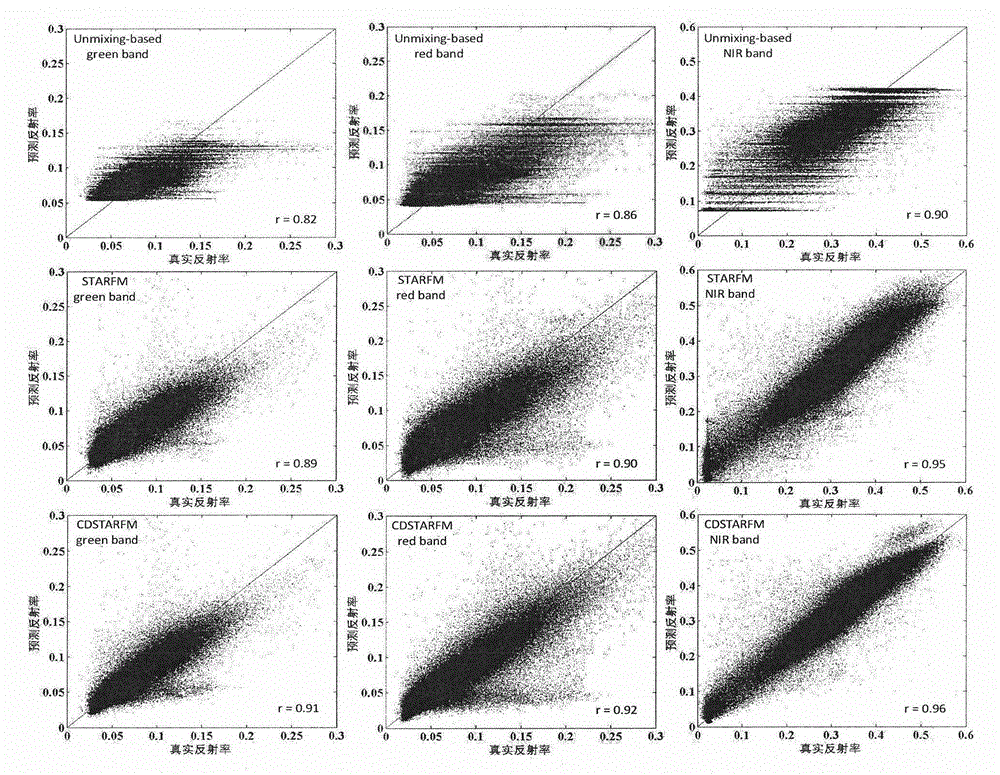
[0043] The invention combines the respective advantages of the pixel decomposition and downscaling algorithm and the space-time adaptive fusion model STARFM, which can not only solve the "pattern" phenomenon of the pixel decomposition and downscaling fusion data, but also increase the purity of the STARFM algorithm to a certain extent. The probability of pixels, thereby improving the accuracy of data fusion. The inp...


PUM


Abstract

The invention discloses a method for constructing high temporal-spatial remote sensing data. A CDSTARFM (combining downscale mixed pixel with spatial and temporal adaptive reflectance fusion model (STARFM)) method performs downscaling treatment on low-resolution data by using a downscale mixed pixel algorithm, replaces direct resample low-resolution data in the STARFM algorithm with the downscaled data, and performs data fusion by using a CDSTARFM algorithm. The method may effectively solve a phenomenon of image spots in downscale mixed pixel data fusion and a problem that it is difficult for the STARFM model to find a pure MODIS pixel. The method constructs the high temporal-spatial-resolution remote sensing data by using Landsat8 and MODIS data. A result manifests that the method has higher fusion precision than the STARFM and downscale mixed pixel algorithms.

Description

technical field [0001] The invention relates to a method for constructing high-temporal remote sensing data, in particular to a method for constructing high-temporal remote sensing data in a fragmented area of ​​land, and belongs to the field of remote sensing image data processing. Background technique [0002] Remote sensing data with high spatial and temporal resolution plays an important role in monitoring land cover changes and crop growth, and identifying types of ground objects. However, the currently obtained satellite sensor data has conflicting spatial resolution, temporal resolution, and spectral resolution, that is, satellite remote sensing data that simultaneously satisfy high spatial, high temporal, and high spectral resolutions is unrealistic. For example, the spatial resolution of the Landsat satellite’s multispectral imagery is 30 meters. Its moderate spatial resolution and ease of acquisition have a wide range of applications in vegetation index extraction,...

Claims


Application Information

Patent Timeline
Patent Type & Authority Applications(China)
IPC IPC(8): G06T3/40G06T5/50
CPCG06T3/4061G06T5/50
Inventor 张锦水谢登峰潘耀忠袁周米琪云雅孙佩军
Owner BEIJING NORMAL UNIVERSITY
Why Eureka
Try Eureka