A short distance optimal bus stop navigation method based on mobile terminal and augmented reality technology

An augmented reality and mobile terminal technology, applied in navigation, surveying and navigation, road network navigator, etc., can solve the problems of low travel efficiency, insufficient real-time information of bus stops, and high error rate of outdoor navigation, achieving real-time improvement, The update is convenient and clear, and the effect of improving travel efficiency

Active Publication Date: 2017-08-22
ZHEJIANG UNIV OF TECH
View PDF10 Cites 0 Cited by
  • Summary
  • Abstract
  • Description
  • Claims
  • Application Information

AI Technical Summary

Problems solved by technology

[0005] In order to overcome the problems of single search and navigation methods for the current location, insufficient real-time bus station information, low travel efficiency, and high outdoor navigation error rate, the present invention considers a short-distance optimal bus station navigation method based on mobile terminals and augmented reality technology, Combining the related technologies of direction perception and image processing to design search and guidance algorithms, this method not only makes the update of bus search convenient and clear, the accuracy and real-time performance are greatly improved, but also realizes short-distance precise navigation to a certain extent, improving the Urban Public Travel Efficiency

Method used


Image

  • A short distance optimal bus stop navigation method based on mobile terminal and augmented reality technology
  • A short distance optimal bus stop navigation method based on mobile terminal and augmented reality technology
  • A short distance optimal bus stop navigation method based on mobile terminal and augmented reality technology

Examples


Embodiment Construction

[0029] The present invention will be further described below in conjunction with the accompanying drawings.

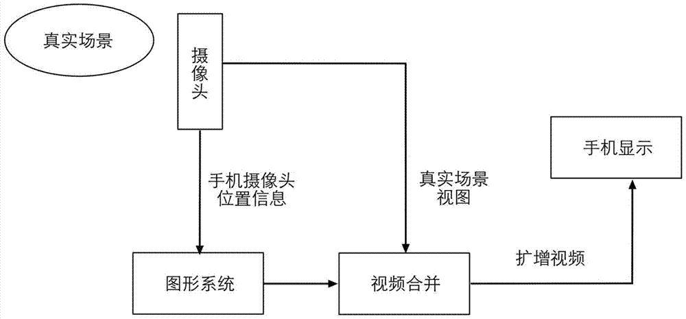
[0030] refer to figure 1 and figure 2 , a short-distance optimal bus station navigation method based on mobile terminals and augmented reality technology, comprising the following steps:

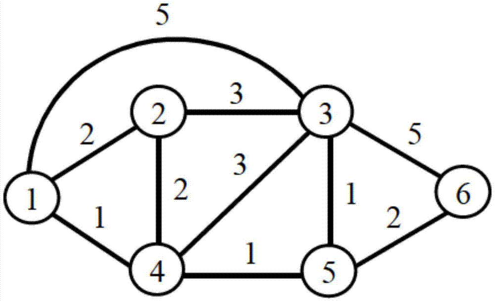
[0031] Step 1: Taking the actual urban area as an example, construct an urban space bus network P=(V P ,E P ,W P ), V P Represents the bus station of the bus network, each node contains the latitude and longitude of the bus station; E P Represents the edge in the bus network, if two bus stops are adjacent on a bus line, they have a connected edge; W P Represents the weight of the edge, that is, the actual physical length of a bus line corresponding to the edge;

[0032] Step 2: Calculate and obtain the best boarding bus stop, determine the departure location O and destination location D, and obtain the latitude and longitude of the destination location through map address ana...


PUM


Abstract

The invention discloses a mobile terminal-augmented reality technology-based close range optimal bus station navigation method. The method comprises 1, constructing an urban spatial public traffic network, 2, according to a destination D and a current position O, computing the optimal bus station where a passenger can take a bus, 3, realizing direction real-time sensing by azimuth angles, 4, constructing a real-time guide road network model R, and 5, by a real-time guide method, accurately guiding the passenger to the optimal bus station where a passenger can take a bus. Through use of the augmented reality technology and direction sensing and bus real-time information feedback functions, the information can be visually displayed in a real scene so that more visual and accurate navigation and real-time information grasp are realized, a small range of accurate navigation is realized, and convenience for user travelling and good user experience are provided.

Description

technical field [0001] The invention relates to the fields of public transportation and mobile development, in particular to a short-distance optimal bus station navigation method based on mobile terminals and augmented reality technology. Background technique [0002] Buses have become an indispensable means of transportation for people to travel, especially under the current energy-saving and environmental protection policies, people are encouraged to drive less private cars when traveling, and choose ways to travel without or with less carbon emissions (such as buses, bicycles, etc.) , to achieve green travel. However, when users travel in public, especially when they arrive in unfamiliar cities or unfamiliar addresses, they often cannot find the best bus stop within a short distance. For example: there is a bus stop in the northeast of the current location, but the user Maybe you can't even tell the difference between southeast and northwest, especially when you go to a...

Claims


Application Information

Patent Timeline
Patent Type & Authority Patents(China)
IPC IPC(8): G01C21/36G01C21/34
CPCG01C21/34G01C21/3647G01C21/3673
Inventor 杨旭华程之凌非俞佳王海洋
Owner ZHEJIANG UNIV OF TECH
Why Eureka
Try Eureka