Supercharge Your Innovation With Domain-Expert AI Agents!

Geological curved surface reconstruction method based on image segmentation

A technology of image segmentation and surface reconstruction, which is applied in the field of electronics, can solve problems such as difficulty in updating, single form of information description, and inconvenient query and analysis, so as to facilitate scientific research and life and overcome limited data

Active Publication Date: 2015-12-09
UNIV OF ELECTRONICS SCI & TECH OF CHINA
View PDF9 Cites 5 Cited by
  • Summary
  • Abstract
  • Description
  • Claims
  • Application Information

AI Technical Summary

Problems solved by technology

Due to its shortcomings such as limited data, difficulty in updating, single form of information description, and inconvenient query and analysis, paper has brought many troubles to scientific research. Therefore, it is necessary to digitize paper-based contour engineering drawings and convert them into convenient computerized electronic information

Method used


Image

  • Geological curved surface reconstruction method based on image segmentation
  • Geological curved surface reconstruction method based on image segmentation
  • Geological curved surface reconstruction method based on image segmentation

Examples


Embodiment Construction

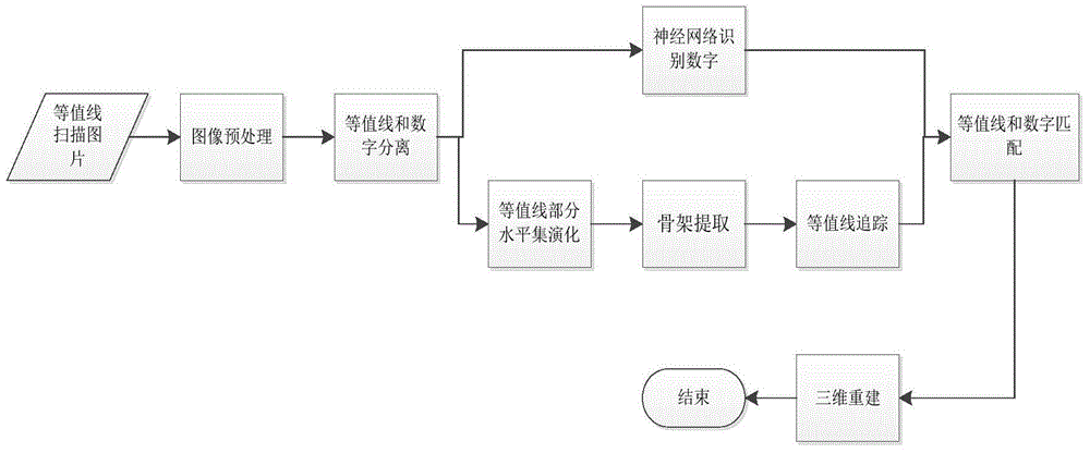
[0049] The present invention will be further elaborated below in conjunction with the accompanying drawings and specific embodiments.

[0050] Such as figure 1 As shown, the geological surface reconstruction method based on image segmentation of the present invention comprises the following steps:

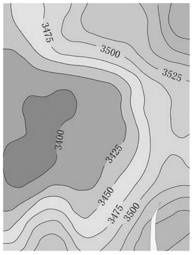
[0051] Step 1, Contour scan picture;

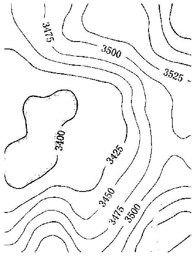
[0052] Step 2, image preprocessing; the image is divided into target points and background points, and filtering is performed to remove noise points; the step 2 includes the following steps:

[0053] Step 21, grayscale processing is performed on the color image. Since the foreground and background of the contour map have a relatively large difference, the threshold value can be directly set for binarization processing; and then the image is divided into two parts, the target point and the background point. The point is 0, the target point is 1;

[0054] Step 22, use a Gaussian smoothing filter to perform filtering.

[0055] figure 2 It i...


PUM


Abstract

The invention discloses a geological curved surface reconstruction method based on image segmentation. The method comprises a step 1 of scanning an image; a step 2 of preprocessing the image; a step 3 of separating an contour line from a figure, enabling the contour line to be processed in the step 4 and enabling the figure to be processed in the step 7; a step 4 of performing level set evolution on the contour line and enabling a result to be processed in the step 5; a step 5 of extracting an contour line skeleton to be processed in the step 6; a step 6 of tracking the contour line and enabling a result to be processed in the step 8; a step 7 of identifying the figure and enabling a result to be processed in the step 8; a step 8 of matching the contour line with the figure; a step 9 of performing three-dimensional reconstruction; and a step 10 of outputting a result. The method has beneficial effects that an acquired three-dimensional contour map displays data variation trend in a three-dimensional image manner. The digital contour map overcomes disadvantages of limited data, difficult update, single information description form, and inconvenient query and analysis of a conventional paper contour map, and facilitates scientific research and lives for people.

Description

technical field [0001] The invention belongs to the field of electronization, in particular to a geological curve reconstruction method based on image segmentation. Background technique [0002] Visualization in Scientific Computing (Visualization in Scientific Computing) emerged in the middle and late 1980s, involving computer graphics, computer vision, computer-aided design and other research fields. It is an important research direction in the field of computer application research. Scientific computing visualization is to obtain a deep understanding of data through calculation and exploration of data, so as to realize the conversion from raw data to graphic images. Visualization technology explains the objective laws contained in abstract data in an intuitive and vivid way, provides accurate, intuitive and convenient technical support for scientific research, and is widely used in many fields such as geological exploration, engineering design, weather forecast, biomedici...

Claims


Application Information

Patent Timeline
IPC IPC(8): G06T17/05G06T7/00
Inventor 姚兴苗宋凯丽胡光岷
Owner UNIV OF ELECTRONICS SCI & TECH OF CHINA
Features
  • R&D
  • Intellectual Property
  • Life Sciences
  • Materials
  • Tech Scout
  • Unparalleled Data Quality
  • Higher Quality Content
  • 60% Fewer Hallucinations
Learn More