Method for multi-dimensional user position location calculation

A positioning calculation, multi-dimensional technology, applied in wireless communication, electrical components, etc., can solve the problem of inability to realize real-time monitoring and analysis of user attendance, check-in, etc., no user terminal measurement strategy control, no data collection, analysis methods, etc. problems, to meet real-time test requirements, increase battery life, and achieve the effect of active alarm

Active Publication Date: 2018-12-21
CHENGDU ASIONSYS IND CO LTD
View PDF4 Cites 0 Cited by
  • Summary
  • Abstract
  • Description
  • Claims
  • Application Information

AI Technical Summary

Problems solved by technology

[0004] However, in the actual application of the existing technology, there are still the following deficiencies: 1. In an open environment, using Beidou / GPS satellite positioning is one of the most accurate methods for user positioning at present. This method does not propose to use Beidou in an open environment. / GPS satellite signal for position positioning method; 2. This method proposes the method of using RSSI and TDOA for positioning, and uses a unified algorithm for position calculation for various wireless signal sources
In the actual operation process, it is necessary to collect the fingerprint parameters of each grid in advance, and the data collection volume is very large, and the fingerprint parameters of the grid will change with time, weather, temperature and other environmental factors, and will also change due to the adjustment of the wireless source , so it is not suitable for the application of all-weather user positioning on a large-area working plane in various industries; 4. This method depends on the TDOA parameter. In actual wireless networks, such as GSM, TDSCDMA, and WCDMA networks, this parameter does not Transmission in the wireless interface requires actual measurement. The measurement value is restricted by the difference, measurement capability, and measurement accuracy of the user terminal. Therefore, the actual use is greatly restricted.
5. This method does not propose a data collection and analysis method at the commuting gate, and cannot realize real-time monitoring and analysis of user attendance and check-in when passing through the commuting gate
6. This method does not propose the measurement strategy control of the user terminal, which is restricted by the battery life of the measurement terminal, and is not suitable for all-weather user trajectory tracking

Method used


Image

  • Method for multi-dimensional user position location calculation

Examples


Embodiment 1

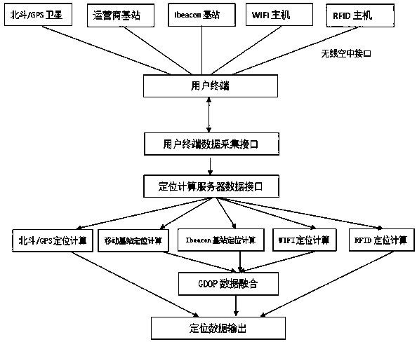
[0039] A method for multi-dimensional user position positioning calculation, comprising: a user terminal transmits collected multi-dimensional related positioning parameters to an integrated management platform through a wireless communication network; Strategy analysis, select the corresponding positioning algorithm for position calculation to obtain positioning data.

[0040] The user terminal is set on personnel and equipment, and relevant positioning parameters include Beidou / GPS satellite signals, mobile base station signals, Ibeacon bluetooth signals, WIFI signals, and RFID signals.

[0041] The comprehensive management platform inserts the positioning data into the database as the basic data of the comprehensive management platform.

[0042] Described method specifically comprises the steps:

[0043] A. The integrated management platform realizes the function configuration of the user terminal through two-way communication between the configured interface server and th...

Embodiment 2

[0065] A method for multi-dimensional user position positioning calculation, comprising:

[0066] The user terminal equipped on the personnel and equipment will collect the relevant multi-dimensional positioning parameters, namely Beidou / GPS satellite signal, mobile base station signal, Ibeacon Bluetooth signal, WIFI signal, RFID signal related positioning parameters, through the operator's wireless communication The network is transmitted to the comprehensive management platform for the geographical location of personnel and equipment; the platform conducts strategic analysis based on the collected relevant data, selects the corresponding positioning algorithm to calculate the location of personnel and equipment, and inserts the final calculation results into the database to serve as personnel and equipment. The basic data of the comprehensive management platform for equipment geographic location.

[0067] Described method specifically comprises the steps:

[0068] A. User t...


PUM


Abstract

The invention discloses a method for locating and calculating a multi-dimensional user position. The method comprises the following steps that: a user terminal transmits acquired multi-dimensional related locating parameters to a comprehensive management platform through a wireless communication network; and the comprehensive management platform performs strategic analysis according to the acquired multi-dimensional related locating parameters and calculates the position according to a corresponding locating algorithm so as to obtain locating data. According to the invention, multi-dimensional position locating of people and equipment in an open environment, an indoor space and a commuting gate can be realized, so that geographical positions, where the people and the equipment are, can be monitored in the whole course; and thus, real-time position data is provided for the comprehensive management platform for managing the geographical positions, where the people and the equipment are.

Description

technical field [0001] The present invention relates to the field of wireless communication applications, in particular to a method for multi-dimensional user position positioning calculation, which is used in a specific industry to use the wireless parameters of wireless sources collected by multi-dimensional positioning and acquisition equipment carried by personnel and equipment data, and calculate the user's geographic location to obtain the geographic location information of personnel and equipment. Background technique [0002] For a series of specific industries, such as mines, large-scale construction sites, forestry, fire protection, shipping, etc., the comprehensive management platform for the geographical location of personnel and equipment realizes comprehensive monitoring, analysis, and management of the geographic location of personnel and equipment. The geographical environment where personnel and equipment are located is mainly divided into open environment, ...

Claims


Application Information

Patent Timeline
Patent Type & Authority Patents(China)
IPC IPC(8): H04W64/00
CPCH04W64/00H04W64/006
Inventor 易强王政于洪志
Owner CHENGDU ASIONSYS IND CO LTD
Why Eureka
Try Eureka