Online automatic matching method for geometric correction of remote sensing image

A remote sensing image, geometric correction technology, applied in image enhancement, image analysis, image data processing and other directions, can solve the problems of changing acquisition conditions, large scenes, complex geometric deformation and so on

Inactive Publication Date: 2015-12-16
INST OF REMOTE SENSING & DIGITAL EARTH CHINESE ACADEMY OF SCI
View PDF4 Cites 12 Cited by
  • Summary
  • Abstract
  • Description
  • Claims
  • Application Information

AI Technical Summary

Problems solved by technology

Although there have been many researches on automatic image matching in the past few decades, the automatic matching of remote sensing images is still very challenging.
Practical automatic matching methods should have good performance in terms of efficiency, robustness, and accuracy. However, due to the large amount of remote sensing image data, large scen...

Method used


Image

  • Online automatic matching method for geometric correction of remote sensing image
  • Online automatic matching method for geometric correction of remote sensing image
  • Online automatic matching method for geometric correction of remote sensing image

Examples


Embodiment Construction

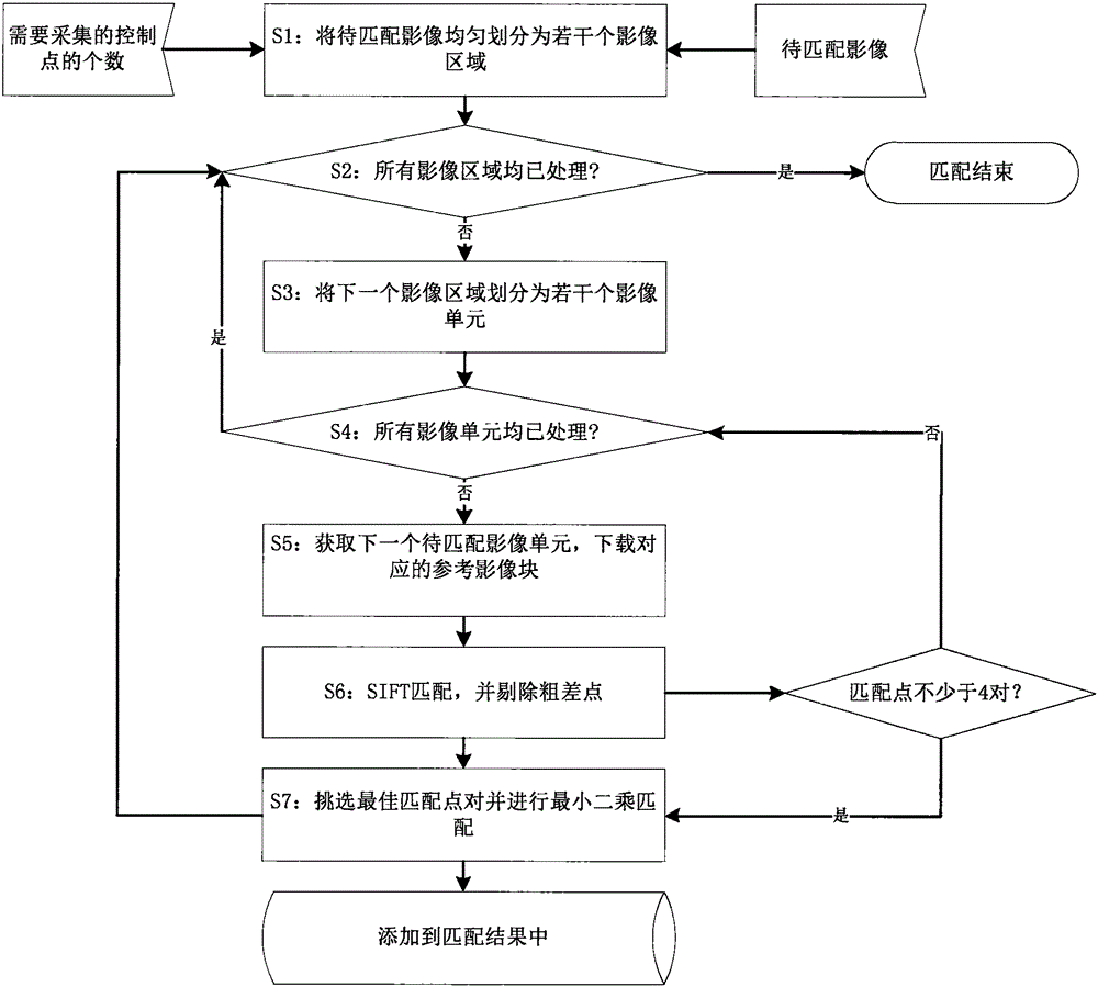
[0029] The online automatic matching method proposed by the present invention is described in detail as follows in conjunction with the accompanying drawings.

[0030] Such as figure 1 As shown, an automatic matching method according to an embodiment of the present invention includes steps:

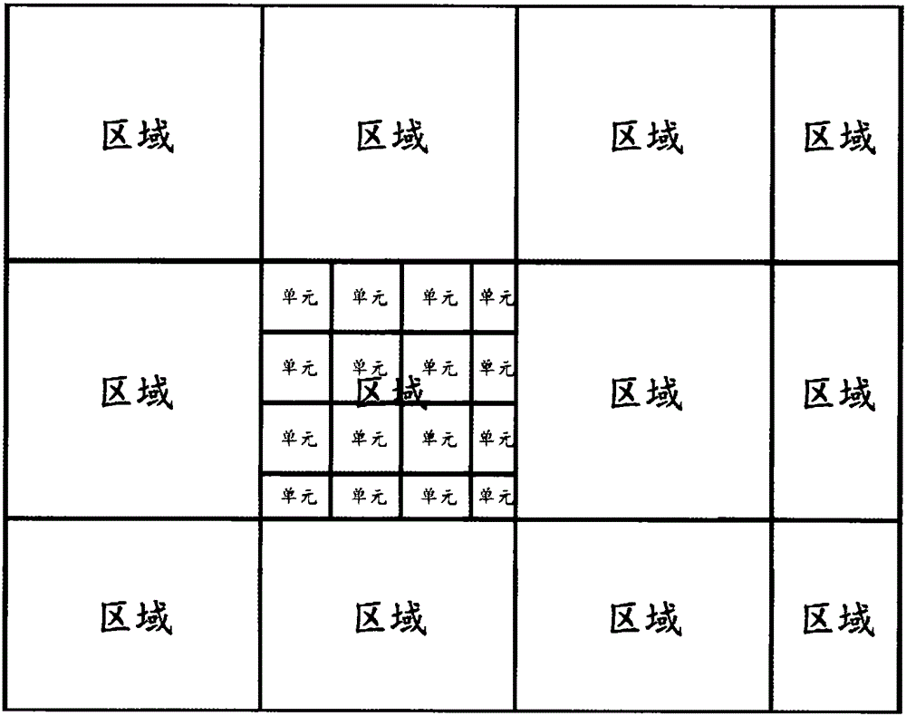
[0031] S1. According to the number of control points to be collected, the remote sensing image to be matched is evenly divided into several regions, and each image region is marked as unprocessed. The schematic diagram of the image region is shown in figure 2 ;

[0032] S2. If all image regions have been processed, complete and end the entire image matching process; otherwise, start processing the next image region;

[0033] S3. Divide the current image area into several image units according to the size of 256 pixels × 256 pixels, and record each image unit as an unprocessed state. See the image unit schematic diagram figure 2 ;

[0034] S4. If all image units in the current image ...


PUM


Abstract

An online automatic matching method for geometric correction of a remote sensing image relates to the technical field of remote sensing image matching. The method has the advantage that uniformly distributed control points are efficiently and reliably obtained by virtue of free or low-cost network image map resources by fully utilizing prior geometric information of the remote sensing image. The method comprises: dividing a to-be-matched image into a plurality of regions according to the number of control points required to be acquired by utilizing an initial imaging model of the remote sensing image, and taking an image block with a certain size in each region as a processing unit; determining an approximate range of a reference image block according to the range of a to-be-matched image unit and the initial imaging model, then downloading the reference image block through a network and re-sampling the reference image block to ensure that the resolution ratio of the reference image block is close to that of the to-be-matched image unit; and performing SIFT matching on the to-be-matched image unit and the reference image block, removing gross error points, finally selecting an optimal matching point from the rest of matching points, performing least square matching, and correcting point coordinates.

Description

technical field [0001] The invention relates to a practical remote sensing image automatic matching method, which can use the network aviation and aerospace image map to perform online automatic matching on the remote sensing image. It can be applied to remote sensing, photogrammetry, surveying and mapping, image processing and other fields. Background technique [0002] Automatic image matching and geometric correction are key links in photogrammetry and remote sensing tasks, and they are the basis for advanced applications such as image fusion, mosaicking, change detection, and map updating. Although there have been many researches on automatic image matching in the past few decades, the automatic matching of remote sensing images is still very challenging. A practical automatic matching method should have good performance in terms of efficiency, robustness, and accuracy. However, due to the large amount of remote sensing image data, large scenes, variable acquisition con...

Claims


Application Information

Patent Timeline
IPC IPC(8): G06T7/00
CPCG06T2207/10032G06T2207/30181
Inventor 龙腾飞焦伟利何国金王威程博张兆明
Owner INST OF REMOTE SENSING & DIGITAL EARTH CHINESE ACADEMY OF SCI
Why Eureka
Try Eureka