Three-dimensional stratum model dynamic construction method
A construction method and technology of 3D strata, applied in 3D modeling, image data processing, instruments, etc., can solve the problem of single display method of stratum model, and achieve the effect of improving unified display, promoting development and utilization, and improving scientificity.
- Summary
- Abstract
- Description
- Claims
- Application Information
AI Technical Summary
Problems solved by technology
Method used
Image
Examples
Embodiment 1
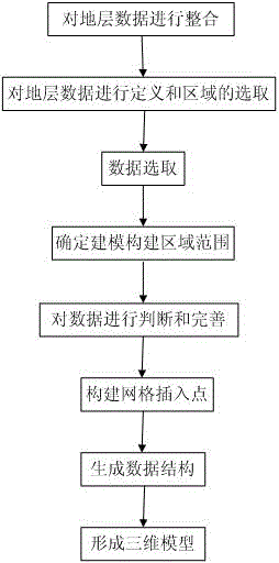
[0066] figure 1 The schematic flow chart of the dynamic construction method of the 3D stratigraphic model provided in this embodiment, as shown in the figure, the method is as follows:
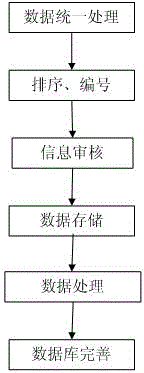
[0067] S1: Integrate stratigraphic data: organize, stratify and perfect stratigraphic data, and then electronically standardize the acquired data of each layer, and store them in different storage formats;
[0068] S2: Define the formation data and select the area: draw up the observation point, calculate the range of the modeling area according to the current direction and position of the observation point; the range of the modeling area can be centered on the current observation point, and determine the range of the modeling area with a certain radius ;
[0069] S3: Data selection: use spatial overlay analysis to select the stratum data in the area to be modeled, extract the stratum information layer by layer according to the stratum number, determine the contour range of the underground d...
Embodiment 2
[0118] figure 1 The schematic flow chart of the dynamic construction method of the 3D stratigraphic model provided in this embodiment, as shown in the figure, the method is as follows:
[0119] S1: Integrate stratigraphic data: organize, stratify and perfect stratigraphic data, and then electronically standardize the acquired data of each layer, and store them in different storage formats;
[0120] S2: Define the stratum data and select the area: determine the scope of the modeling area in a custom way according to the position of the viewpoint;
[0121] S3: Data selection: use spatial overlay analysis to select the stratum data in the area to be modeled, extract the stratum information layer by layer according to the stratum number, determine the contour range of the underground data; determine the three-dimensional model organization structure of each stratum;
[0122] S4: Determine the scope of the modeling construction area: determine the construction area of the 3D mo...
PUM
 Abstract
Description
Claims
Application Information
 - R&D
- Intellectual Property
- Life Sciences
- Materials
- Tech Scout
- Unparalleled Data Quality
- Higher Quality Content
- 60% Fewer Hallucinations
Browse by: Latest US Patents, China's latest patents, Technical Efficacy Thesaurus, Application Domain, Technology Topic, Popular Technical Reports.
© 2025 PatSnap. All rights reserved.Legal|Privacy policy|Modern Slavery Act Transparency Statement|Sitemap|About US| Contact US: help@patsnap.com


