Spatial data conversion method and system

A technology of spatial data and data, applied in the computer field, can solve problems such as irregular data in AutoCAD, no coding of thickness values ​​of ground objects, and no classification of data, so as to improve scalability and readability, and to query and read attributes. Take the effect of improving and increasing usability

Active Publication Date: 2016-01-27
张新长
View PDF3 Cites 31 Cited by
  • Summary
  • Abstract
  • Description
  • Claims
  • Application Information

AI Technical Summary

Problems solved by technology

There are mainly the following reasons: 1) The AutoCAD data is not standardized, and the inspection of the drawing is emphasized. Some ground object thickness values ​​are not coded, or the original code is not standardized. Transfer to Geoway according to the code comparison table, and there will be a lot of data Not classified well, resulting in additional workload
2) The workload of faceting is also very large

Method used


Image

  • Spatial data conversion method and system
  • Spatial data conversion method and system
  • Spatial data conversion method and system

Examples


Embodiment Construction

[0061] The following will clearly and completely describe the technical solutions in the embodiments of the present invention with reference to the accompanying drawings in the embodiments of the present invention. Obviously, the described embodiments are only some, not all, embodiments of the present invention. Based on the embodiments of the present invention, all other embodiments obtained by persons of ordinary skill in the art without creative efforts fall within the protection scope of the present invention.

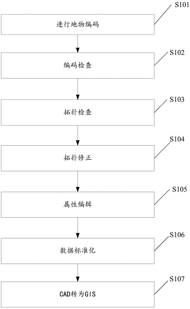
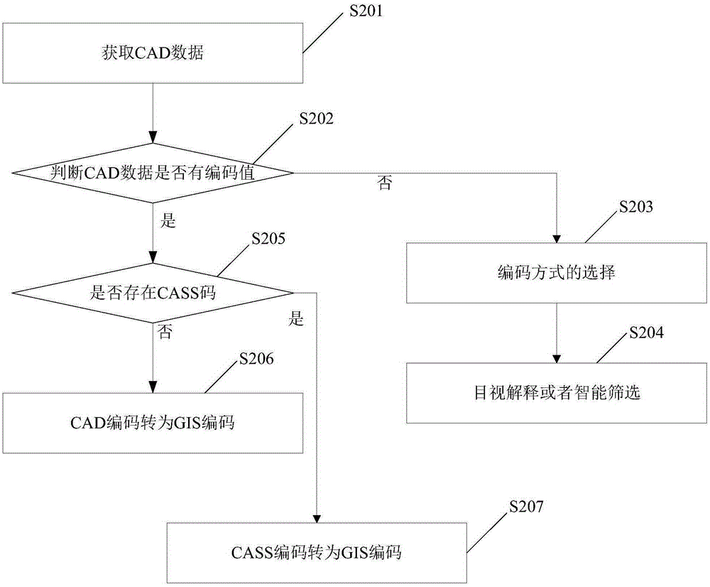
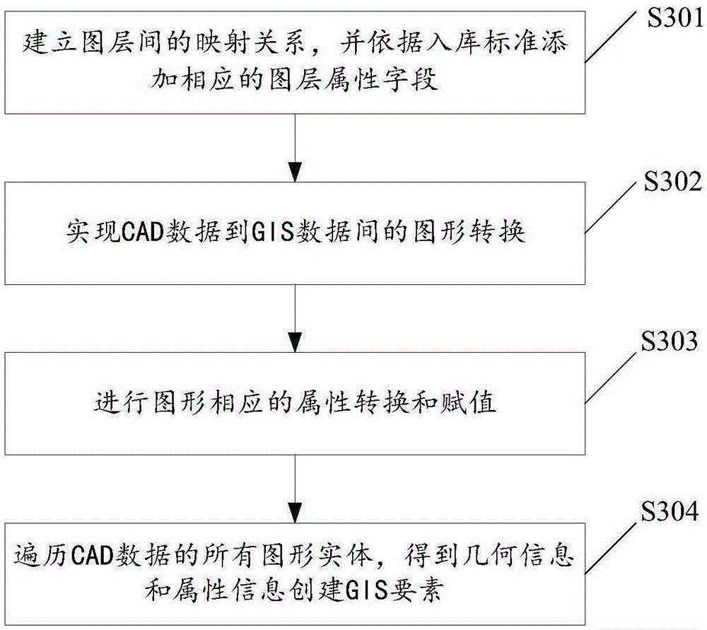
[0062] A method for spatial data conversion in the present invention mainly includes: performing ground object coding, and adopting GIS codes for storing topographical elements to mark CAD data; redrawing graphic data for CAD data after marking using the corresponding features of graphics, so that The CAD data is normalized; the normalized CAD data is converted to GIS data, wherein: the normalized CAD data is converted to GIS data including: creating a personal geog...


PUM


Abstract

The invention discloses a spatial data conversion method and system. The method comprises: performing land feature coding, and marking CAD data by adopting GIS codes storing topographical elements; re-drawing graphic data by adopting features corresponding to graphs for the marked CAD data to normalize the CAD data; and converting the normalized CAD data into GIS data. A whole set of processing process is provided through an embodiment of the invention and comprises the functions of land feature batch coding, topologic check, specific graphic layer screening or exporting all data for the GIS and the like.

Description

technical field [0001] The invention relates to the field of computer technology, in particular to a method and system for converting spatial data. Background technique [0002] Discussion on the existing issues related to the conversion of CAD urban basic data to GIS, mainly discusses some problems in the conversion of urban basic CAD data to GIS data, and introduces the method of converting CAD data to GIS data based on Geoway, and the existence of this method some defects. Using Geoway to convert CAD data to GIS data has many advantages, mainly as follows: 1) The converted data has less deformation and basically maintains the geometric shape and shape of the original graphics; 2) The conversion process can be processed in batches with high efficiency; 3) The converted data can use Geoway to form a topology structure and generate an attribute table file, and the final data obtained can be directly used by GIS software. [0003] In the technical research and application o...

Claims


Application Information

Patent Timeline
Patent Type & Authority Applications(China)
IPC IPC(8): G06F17/30
CPCG06F16/258G06F16/29
Inventor 张新长
Owner 张新长
Why Eureka
Try Eureka