MODIS remote sensing evaluation method for eutrophication lake algae gauss vertical distribution structural parameters

A technology of vertical distribution and structural parameters, which is applied in calculation, electrical digital data processing, special data processing applications, etc., and can solve problems such as not reflecting the eutrophication of water bodies

Active Publication Date: 2016-02-03
NANJING INST OF GEOGRAPHY & LIMNOLOGY
View PDF4 Cites 17 Cited by
  • Summary
  • Abstract
  • Description
  • Claims
  • Application Information

AI Technical Summary

Problems solved by technology

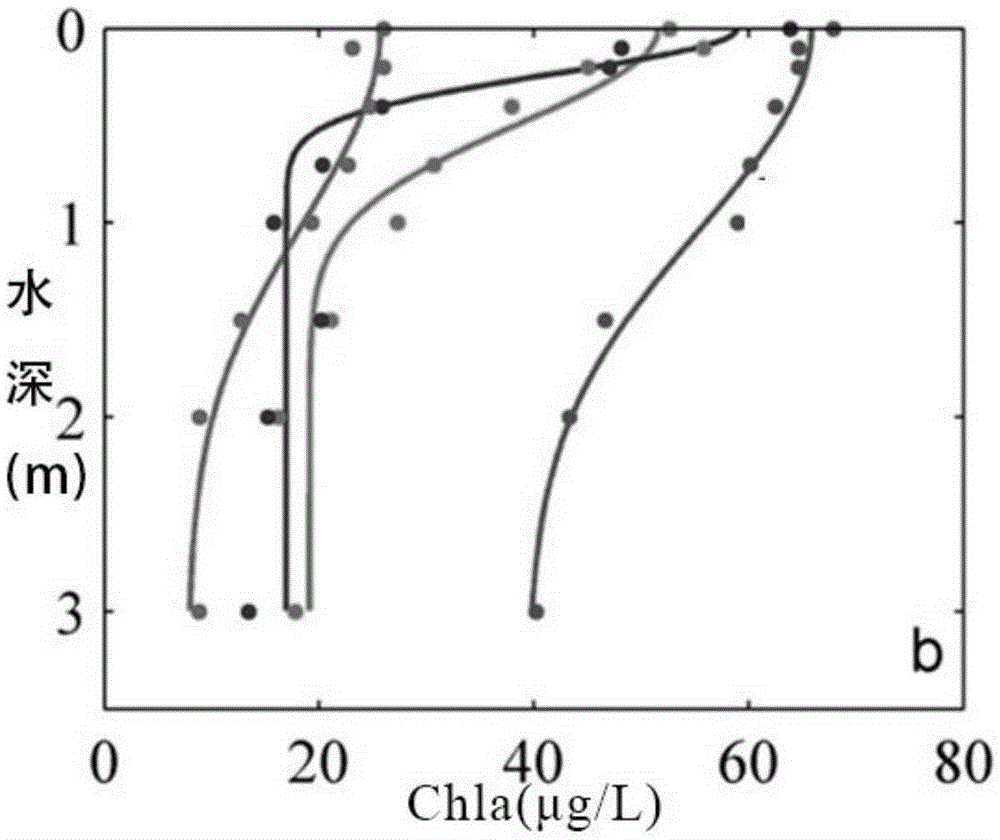
Changes in the vertical structure of algae make it impossible to monitor the eutrophication of the entire water body only by monitoring algal blooms on the water surface
Moreover, there are great challenges in the accuracy of optical parameters retrieved by remote sensing (Stramska and Stramski2005) and the estimation of pigmented biomass (Silulwane et al.2010).

Method used


Image

  • MODIS remote sensing evaluation method for eutrophication lake algae gauss vertical distribution structural parameters
  • MODIS remote sensing evaluation method for eutrophication lake algae gauss vertical distribution structural parameters
  • MODIS remote sensing evaluation method for eutrophication lake algae gauss vertical distribution structural parameters

Examples


Embodiment Construction

[0030] In order to better understand the technical content of the present invention, specific embodiments are given together with the attached drawings for description as follows.

[0031] Aspects of the invention are described in this disclosure with reference to the accompanying drawings, which show a number of illustrated embodiments. Embodiments of the present disclosure are not necessarily intended to include all aspects of the invention. It should be understood that the various concepts and embodiments described above, as well as those concepts and embodiments described in more detail below, can be implemented in any of a number of ways, which should be the concepts and embodiments disclosed by the present invention and not Not limited to any implementation. In addition, some aspects of the present disclosure may be used alone or in any suitable combination with other aspects of the present disclosure.

[0032] The present invention provides a MODIS remote sensing esti...


PUM


Abstract

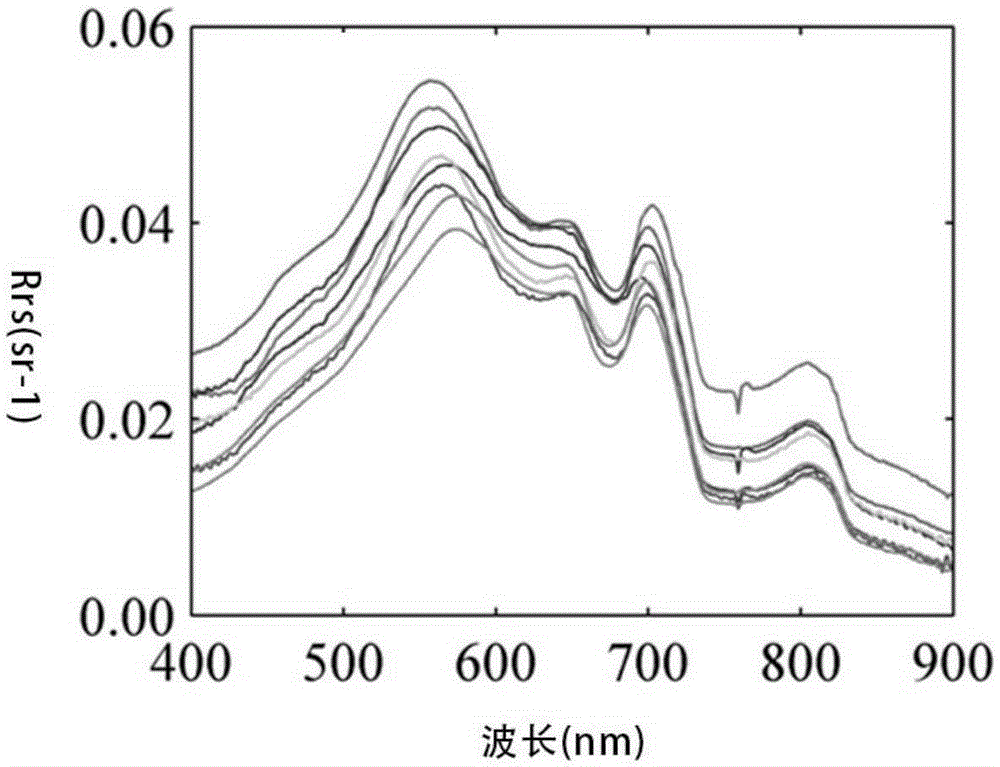
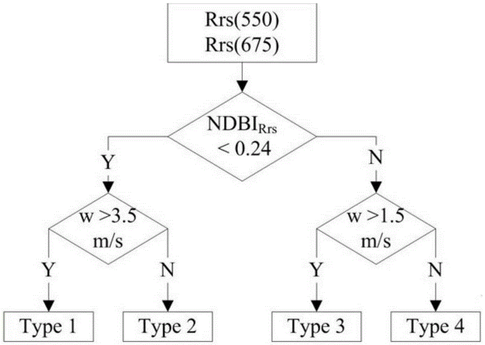
The invention provides a MODIS remote sensing evaluation method for eutrophication lake algae gauss vertical distribution structural parameters. Based on field actual measurement data, a function expression and remote sensing identification method for the same for alge gauss vertical distribution are determined with a combination a alge bloom identification index NDBI and synchronous external environment factor wind speed; based on Hydrolight radiation transferring simulation, ground spectrum database of different alge gauss vertical distribution can be built; by the use of a BP neural network model, a remote sensing evaluation method for the lake algae gauss vertical distribution structural parameters based on simulation data is built; with simulation of various aerosol types, thickness, various solar altitude, satellite observation angles and azimuthal angles, a quantitative relation between ground-based simulation remote sensing reflectance ratio Rrs and a simulated Rayleigh scattering corrected Rrc is acquired; the evaluation method for the algae gauss vertical distribution structural parameters based on spectrum data simulation can be promoted to MODIS satellite image data corrected by Rayleigh scattering.

Description

technical field [0001] The invention relates to a MODIS remote sensing estimation method for the Gaussian vertical distribution structure parameters of algae in eutrophic lakes Background technique [0002] In eutrophic water bodies, remote sensing methods have been widely used to monitor the outbreak degree and frequency of algal blooms (Bresciani et al.2014; Hu2009; Kahrue et al.2007; Kutser et al.2006; Odermatt et al.2012), and also carried out inversion of pigment concentration A lot of work, for example, chlorophyll concentration (Duan et al. 2010; Song etal. 2013b), phycocyanin concentration (Duan et al. 2012; Song et al. 2013a), etc. Most of these works are based on the inversion of optical parameters of surface water or the assumption of vertical uniformity of water column. However, remote sensing signals reflect the vertical structure at a certain depth below the water surface, and only relying on the surface layer will introduce errors. [0003] The area of ​​alg...

Claims


Application Information

Patent Timeline
Patent Type & Authority Applications(China)
IPC IPC(8): G06F19/00
Inventor 张玉超马荣华段洪涛梁其椿
Owner NANJING INST OF GEOGRAPHY & LIMNOLOGY
Why Eureka
Try Eureka