Remote sensing image registration method based on anisotropic gradient dimension space
A remote sensing image and anisotropy technology, applied in the field of image processing, can solve the problems of inaccurate registration of image brightness, large nonlinear changes in brightness, reduced algorithm performance, and inability of sift algorithm to obtain initial solutions.
- Summary
- Abstract
- Description
- Claims
- Application Information
AI Technical Summary
Problems solved by technology
Method used
Image
Examples
Embodiment Construction
[0083] The present invention will be described in further detail below in conjunction with the accompanying drawings.
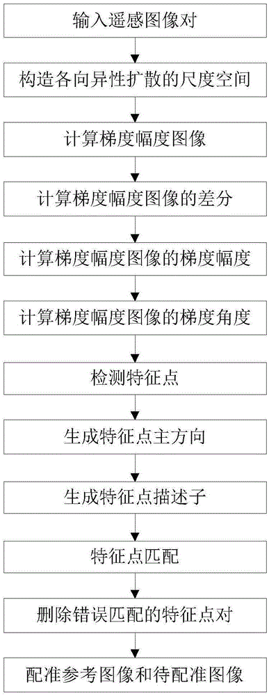
[0084] Refer to attached figure 1 , the steps of the present invention are as follows.
[0085] Step 1, input remote sensing image pair.
[0086] Input the reference remote sensing image and the remote sensing image to be registered.
[0087] Step 2, constructing the scale space of anisotropic diffusion.
[0088] (2a) Calculate the scale values of each layer in the anisotropic scale space of the reference remote sensing image and the remote sensing image to be registered:
[0089] σ e (m, u) = σ 0 2 m+u / L
[0090] Among them, σ e Indicates the scale value of the e-th layer of the anisotropic scale space of the reference remote sensing image or the remote sensing image to be registered, σ 0 Indicates the reference scale value of the reference remote sensing image or the remote sensing image to be registered. The anisotropic scale space has G groups,...
PUM
 Abstract
Description
Claims
Application Information
 - R&D
- Intellectual Property
- Life Sciences
- Materials
- Tech Scout
- Unparalleled Data Quality
- Higher Quality Content
- 60% Fewer Hallucinations
Browse by: Latest US Patents, China's latest patents, Technical Efficacy Thesaurus, Application Domain, Technology Topic, Popular Technical Reports.
© 2025 PatSnap. All rights reserved.Legal|Privacy policy|Modern Slavery Act Transparency Statement|Sitemap|About US| Contact US: help@patsnap.com


