Road coupling method and apparatus thereof

A matching method and road technology, applied in the field of geographic information system, can solve the problem of inaccurate matching between GPS points and roads

Active Publication Date: 2016-04-27
ALIBABA (CHINA) CO LTD
View PDF8 Cites 20 Cited by
  • Summary
  • Abstract
  • Description
  • Claims
  • Application Information

AI Technical Summary

Problems solved by technology

[0005] In order to solve the above technical problems, the embodiment of the present invention provides a road ma

Method used


Image

  • Road coupling method and apparatus thereof
  • Road coupling method and apparatus thereof
  • Road coupling method and apparatus thereof

Examples


Embodiment Construction

[0035] In order to make the above objects, features and advantages of the present invention more comprehensible, the embodiments of the present invention will be described in detail below in conjunction with the accompanying drawings.

[0036] method embodiment

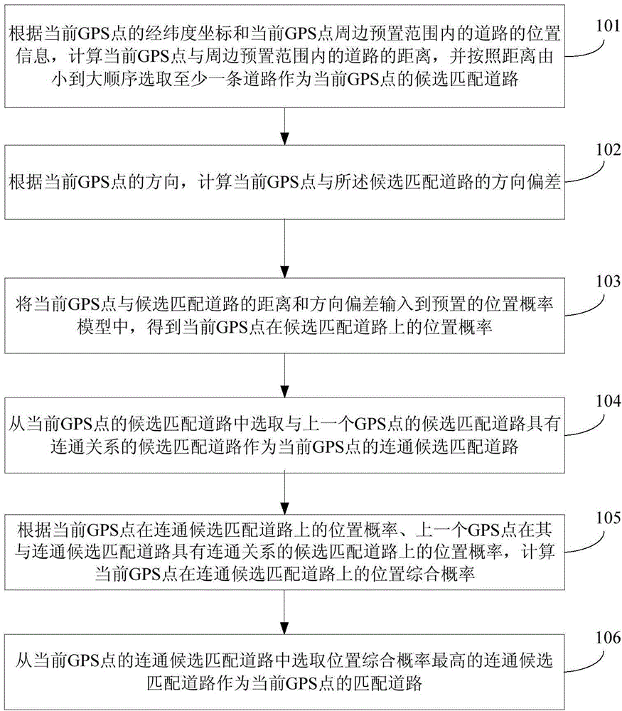
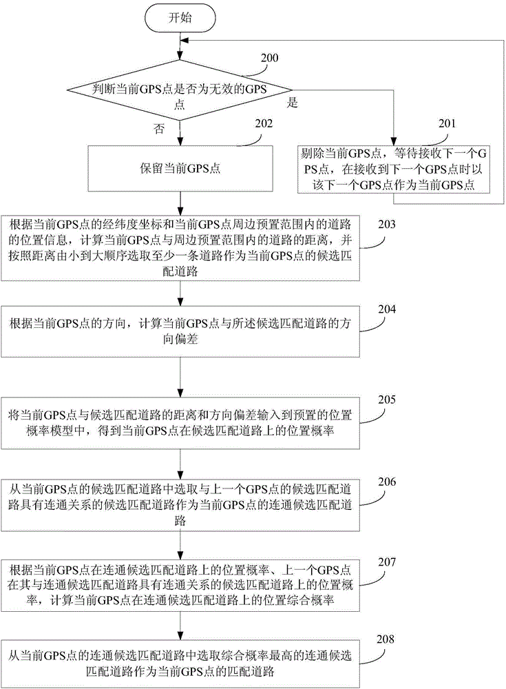
[0037] see figure 1 As shown, it is a flowchart of an embodiment of a road matching method provided by the present invention, and the method includes the following steps:

[0038] Step 101: According to the latitude and longitude coordinates of the current GPS point and the location information of the roads within the preset range around the current GPS point, calculate the distance between the current GPS point and the roads within the preset range around the current GPS point, and select at least A road is used as a candidate matching road for the current GPS point.

[0039] Step 102: Calculate the direction deviation between the current GPS point and the candidate matching road according to the direction of the...


PUM


Abstract

The invention discloses a road coupling method and an apparatus thereof. The method comprises the following steps: determining a candidate coupling road at a current GPS point; calculating direction deviation of the current GPS point and the candidate coupling road; inputting the distance and the direction deviation of the current GPS point and the candidate coupling road to a position probability model, obtaining the position probability of the current GPS point on the candidate coupling road; selecting the communicated candidate coupling road in the candidate coupling road of the current GPS point; according to the position probability of the current GPS point on the communicated candidate coupling road and position probability of the candidate coupling road having a communication relation with the communicated candidate coupling road of the last GPS point, calculating the position comprehensive probability of the current GPS point on the communicated candidate coupling road; and selecting the communicated candidate coupling road with highest position comprehensive probability as the coupling road of the current GPS point. According to the invention, problem of inaccurate coupling of the GPS point and the road in prior art can be solved.

Description

technical field [0001] The invention relates to the field of geographic information systems, in particular to a road matching method and device. Background technique [0002] In the prior art, the main ways to match GPS points to roads are: [0003] According to the longitude and latitude coordinates of the GPS point, the distance between the GPS point and each road in the road network is calculated, and the road with the closest distance is determined as the road matched by the GPS point. But this road matching method has the following defects: [0004] Due to certain errors in GPS positioning itself, the GPS point obtained by positioning may drift away from the actual road where the user is currently located. The road with the closest point distance is not the road where the user is actually currently located, but other roads close to the road where the user is currently actually located. Therefore, the matching method provided by the prior art has the problem of inaccur...

Claims


Application Information

Patent Timeline
IPC IPC(8): G01C21/30
Inventor 毛灵飞
Owner ALIBABA (CHINA) CO LTD
Why Eureka
Try Eureka