Beidou satellite navigation system performance monitoring device and monitoring method thereof

A Beidou satellite and navigation system technology, applied in the field of satellite navigation, can solve the problems of real-time monitoring of system performance, real-time monitoring of no Beidou telegrams, etc., to achieve the effect of convenient query, reduce damage, and improve solution efficiency

Inactive Publication Date: 2016-04-27
郑州威科姆科技股份有限公司
View PDF7 Cites 26 Cited by
  • Summary
  • Abstract
  • Description
  • Claims
  • Application Information

AI Technical Summary

Problems solved by technology

At present, my country has no inventions for real-time monitoring of Beidou messages and real-time monitoring of system performance.

Method used


Image

  • Beidou satellite navigation system performance monitoring device and monitoring method thereof
  • Beidou satellite navigation system performance monitoring device and monitoring method thereof
  • Beidou satellite navigation system performance monitoring device and monitoring method thereof

Examples


Embodiment Construction

[0034] The present invention will be described in further detail below in conjunction with the accompanying drawings and specific embodiments.

[0035]According to the second edition of the Beidou space signal interface control document published by the China Satellite Navigation System Management Office in 2013, the Beidou satellite navigation system is referred to as its space constellation consisting of 5 geostationary orbit (GEO) satellites and 27 medium earth orbit (MEO) satellites. and three inclined geosynchronous orbit (IGSO) satellites. As of the end of 2013, there are 5 geostationary orbit (GEO) satellites, 4 medium earth orbit (MEO) satellites and 5 inclined geosynchronous orbit (IGSO) satellites in orbit.

[0036] By the end of 2013, the frequencies of Beidou satellite signals are B1, B2 and B3, of which B3 is a military frequency. With the construction of the Beidou system, other frequencies will be added in succession. The types of navigation messages broadcast b...


PUM


Abstract

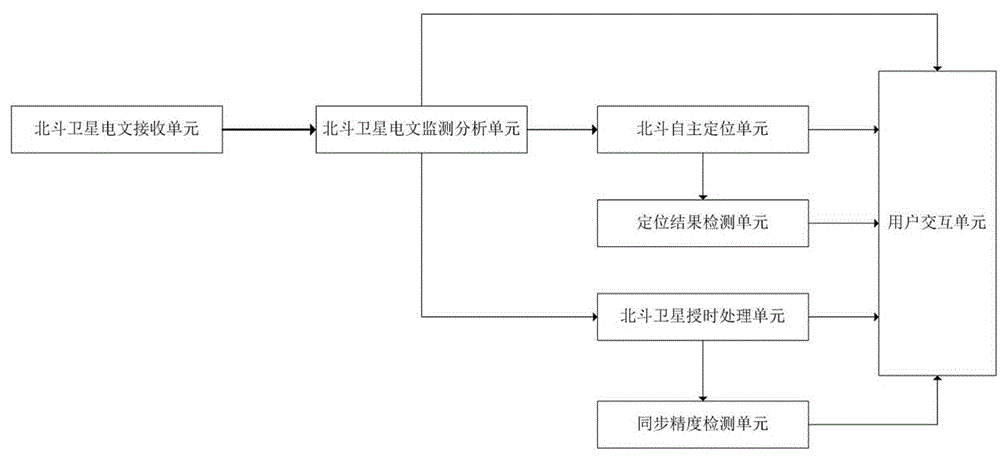
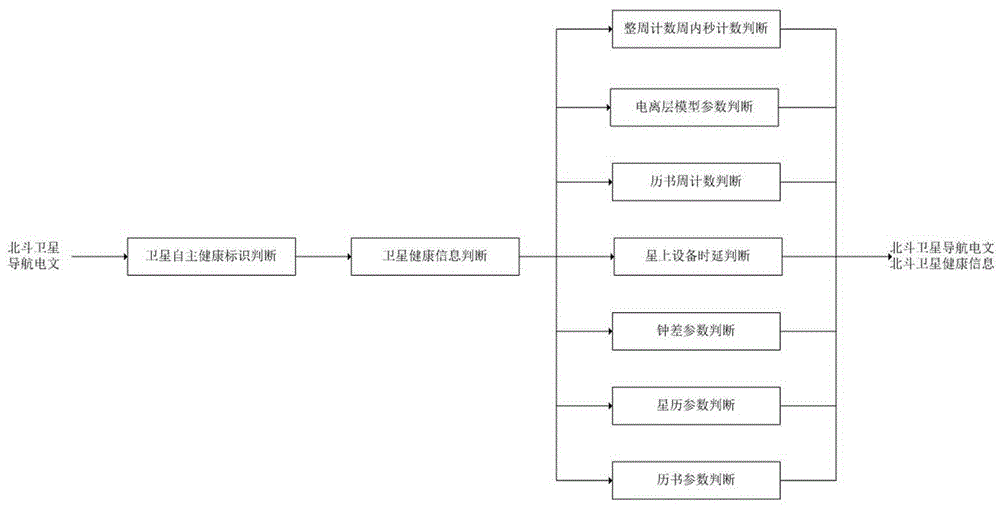
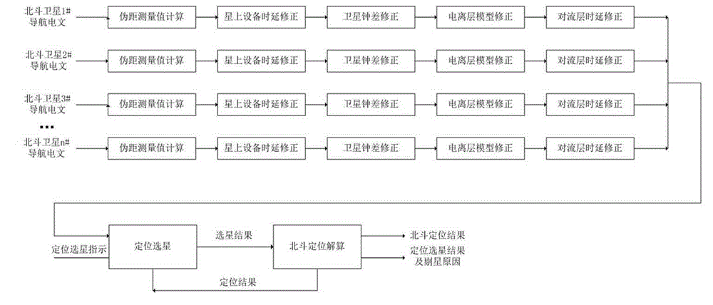
The invention relates to a Beidou satellite navigation system performance monitoring device. The Beidou satellite navigation system performance monitoring device comprises a Beidou satellite text reception unit, a Beidou text monitoring analysis unit, a Beidou satellite autonomous positioning unit, a Beidou satellite time service unit, a positioning result detection unit, a synchronization precision detection unit, a user interaction unit and a power supply unit. The invention further provides a monitoring method for the Beidou satellite navigation system performance monitoring device. Abnormal text and data are timely identified and indicated in a satellite text monitoring process, corresponding measures can be conveniently adopted, reduction of damage caused by the abnormal text data is facilitated; accuracy of each type of text data can be identified, which satellite has abnormal parameters can be acquired through back stepping according to the positioning and time service result, abnormality reasons can be rapidly positioned on the condition of positioning and time service, and solution efficiency is improved. Beidou positioning and time service are carried out in real time, mastering performance of Beidou systems can be facilitated, reasonable positioning and time service algorithms can be selected, and development of high-performance Beidou application products is facilitated.

Description

technical field [0001] The invention belongs to the field of satellite navigation, and relates to a Beidou satellite navigation system performance monitoring device and a monitoring method thereof. Background technique [0002] The Beidou satellite navigation system is designed and constructed independently by my country. In December 2012, the Beidou space signal interface control document was announced, marking its official operation, providing high-performance services for China and surrounding areas, and building it into a global coverage by 2020. Navigation and positioning system. The Beidou satellite navigation system has positioning, timing and communication functions, and plays an important role in my country's electric power, telecommunications, transportation, finance and military industries. [0003] At present, the construction of the Beidou satellite navigation system is in the final stage of the "three-step process". More satellites will be launched, and its app...

Claims


Application Information

Patent Timeline
Patent Type & Authority Applications(China)
IPC IPC(8): G01S19/01
Inventor 贾小波李军华吴淑琴张筱南邹世合谢成玉
Owner 郑州威科姆科技股份有限公司
Why Eureka
Try Eureka