Method for determining a current position of a motor vehicle in a geodetic coordinate system and motor vehicle

A geodetic coordinate system and actual position technology, applied in satellite radio beacon positioning system, measurement device, radio wave measurement system, etc., can solve the problems of laborious compensation and waiting time, and achieve the effect of great stability

Active Publication Date: 2016-05-04
AUDI AG
View PDF4 Cites 2 Cited by
  • Summary
  • Abstract
  • Description
  • Claims
  • Application Information

AI Technical Summary

Problems solved by technology

Latency must be laboriously compensated for whe

Method used


Image

  • Method for determining a current position of a motor vehicle in a geodetic coordinate system and motor vehicle
  • Method for determining a current position of a motor vehicle in a geodetic coordinate system and motor vehicle
  • Method for determining a current position of a motor vehicle in a geodetic coordinate system and motor vehicle

Examples


Embodiment Construction

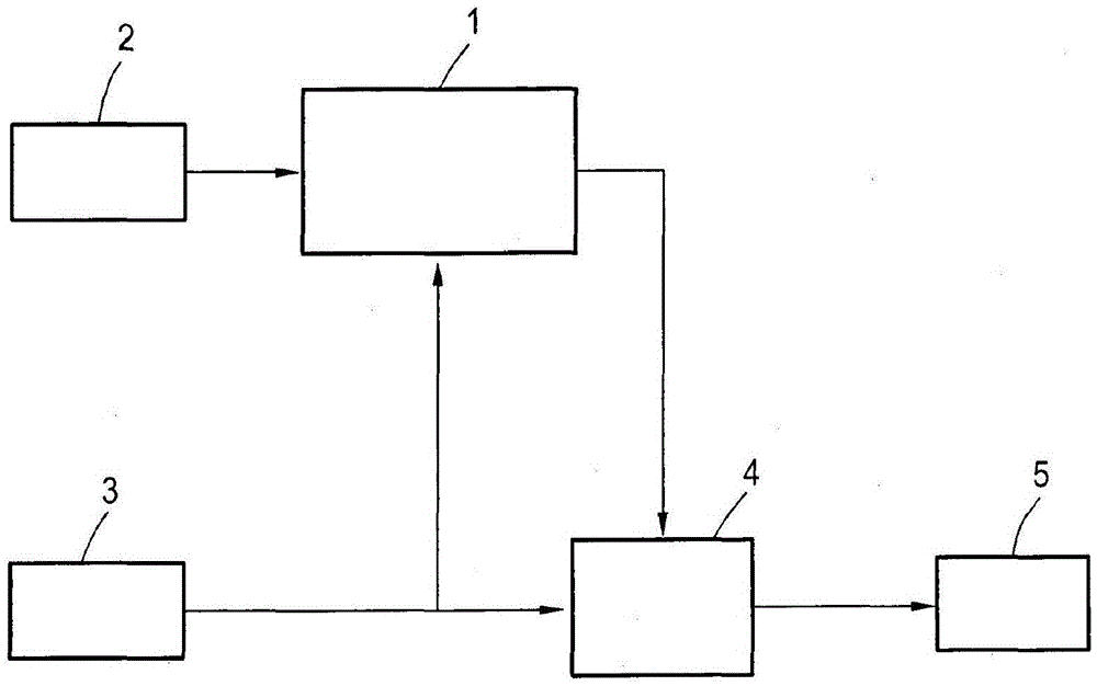
[0027] figure 1 An overview diagram for carrying out the method according to the invention is shown. The method is finally carried out on two different time scales, recalculating the transformation parameters every 5 seconds from the position data 2 and the own movement data 3 in step 1, and at the same time significantly more frequently from the reference time point in step 4 For example, the transformation is applied to the actual, significantly more frequently occurring displacement vectors at a frequency of greater than 10 Hz. In short: the method first obtains the transformation relative to the reference time point in step 1 and the displacement vector describing the position change since the reference time point, and then transforms the displacement vector into the global geodetic coordinate system in step 4 , so that a highly accurate and actual position 5 can be obtained in exchange. The above method will be explained in more detail below.

[0028] In step 1, a pres...


PUM


Abstract

The invention relates to a method for determining a current position (5) of a motor vehicle (6) in a geodetic coordinate system from a time series of first geodetic position data (2), in particular recorded by means of a position sensor (8) associated with a global navigation satellite system, and of ego-motion data (3) recorded by means of at least one ego-motion sensor (9), wherein the position is determined by applying a transformation into the geodetic coordinate systemonto a displacement vector of the motor vehicle (6) derived from the latest of the ego-motion data (3) starting from a reference time to which the transformation relates, wherein the transformation is determined in a regression analysis as an optimal mapping of a progression of displacement vectors determined over a defined time period to a progression of the position data (2) determined for the same time period.

Description

technical field [0001] The invention relates to a method for acquiring the actual position of a motor vehicle in a geodetic coordinate system from a first geodetic position, in particular acquired by a position sensor assigned to a global navigation satellite system The time series of the data is obtained through self-movement data collected by at least one self-movement sensor. Furthermore, the invention relates to a motor vehicle. Background technique [0002] Position information as precise as possible is practical in modern motor vehicles for various vehicle systems, in particular for navigation systems, which may contain some highly precise information, for example information about roadblocks. An attempt is thereby made to determine the position of the motor vehicle as precisely as possible. For this purpose, it is proposed to use position sensors which are able to localize the motor vehicle on the basis of the Global Navigation Satellite System (GNSS), for example G...

Claims


Application Information

Patent Timeline
IPC IPC(8): G01C21/28G01S19/49
CPCG01C21/28G01S19/49
Inventor C·西蒙F·米克勒A·托尔金
Owner AUDI AG
Why Eureka
Try Eureka