Motorized high precision sandy shoreline and mud shoreline measuring device

A measuring device and high-precision technology, applied in the field of satellite positioning, can solve problems such as inability to solve high-precision shoreline measurement, and achieve the effects of convenient calculation of roll angle, accurate positioning, and correction of antenna position offset

Inactive Publication Date: 2016-05-11
THE FIRST INST OF OCEANOGRAPHY SOA
View PDF3 Cites 1 Cited by
  • Summary
  • Abstract
  • Description
  • Claims
  • Application Information

AI Technical Summary

Problems solved by technology

Therefore, it cannot solve the problem of high-precision shoreline measurement on sandy or muddy coasts

Method used


Image

  • Motorized high precision sandy shoreline and mud shoreline measuring device
  • Motorized high precision sandy shoreline and mud shoreline measuring device

Examples


Embodiment Construction

[0021] In order to make the purpose, technical solutions and advantages of the embodiments of the present invention clearer, the technical solutions in the embodiments of the present invention will be clearly and completely described below in conjunction with the drawings in the embodiments of the present invention. Obviously, the described embodiments It is a part of embodiments of the present invention, but not all embodiments. Based on the embodiments of the present invention, all other embodiments obtained by persons of ordinary skill in the art without creative efforts fall within the protection scope of the present invention.

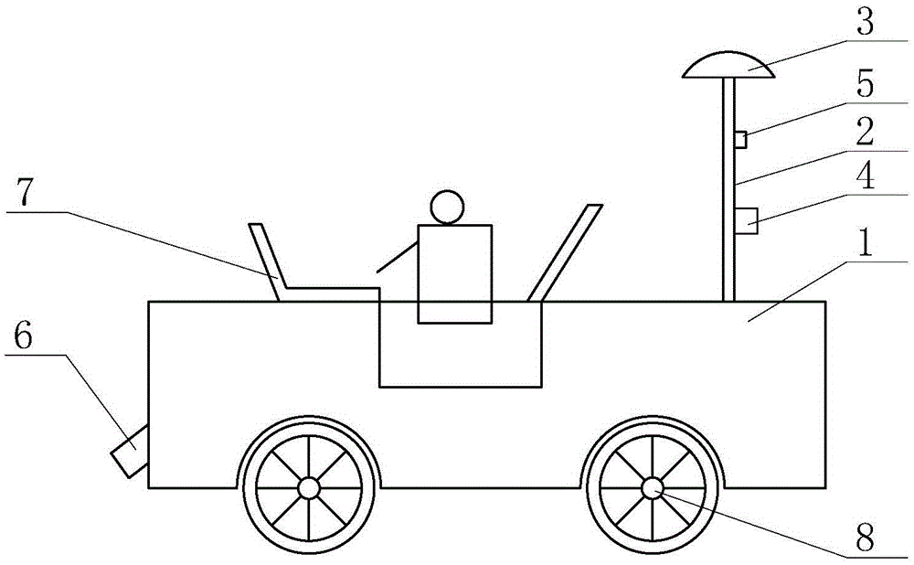
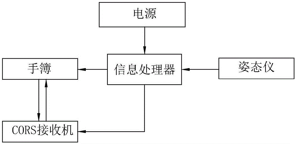
[0022] combined with figure 1 , attached figure 2 , to further describe in detail the specific embodiment of the present invention, a mobile high-precision sandy shoreline and muddy shoreline measuring device, including a movable device 1, a measuring rod 2 is installed above the rear end of the movable device 1, and the measuring rod 2 A CORS ...


PUM


Abstract

Provided is a motorized high precision sandy shoreline and mud shoreline measuring device, comprising a mobile device which is provided with a vertical measuring bar; the measuring bar is provided with a CORS receiver, a record book, and an attitude indicator. The front end middle position of the mobile device is provided with a laser emitter which can emit a laser beam used for positioning a shoreline position. The mobile device is also provided with an information processor which is in connection with the record book and the attitude indicator through data lines, wherein the record book and the CORS receiver are in both-way communication; the information processor is internally provided with a processing module. The motorized high precision sandy shoreline and mud shoreline measuring device is a professional device for sandy shoreline and mud shoreline measurement, and can precisely position a coastline position, and perform correction treatment on an obtained sandy shoreline and mud shoreline through the information processor, thereby rapidly and accurately measuring sandy shoreline and mud shoreline positions.

Description

technical field [0001] The invention relates to a coastline measuring device, which belongs to the technical field of satellite positioning, in particular to a motorized high-precision sandy coastline and muddy coastline measuring device. Background technique [0002] Coastline is the dividing line between ocean and land, and is an important part of marine land resources. Determining the location of the coastline is a necessary technical activity for people to study sea-land interaction, marine geology, climate change and environmental protection, and it is also an important part of coastal topographic mapping and marine surveys. Accurate detection is of great significance. The existing coastline surveying and mapping technologies include remote sensing and traditional on-site surveying. Coastline surveying and mapping based on remote sensing has low cost and wide range, but the accuracy of coastline surveying is low, especially on sandy coastlines and muddy coastlines with...

Claims


Application Information

Patent Timeline
Patent Type & Authority Applications(China)
IPC IPC(8): G01S19/14
CPCG01S19/14
Inventor 孙伟富马毅胡亚斌梁浩
Owner THE FIRST INST OF OCEANOGRAPHY SOA
Why Eureka
Try Eureka