
Coordinate point processing method and device for electronic map interface

An electronic map and processing method technology, applied in the GIS (Geographic Information System) application field, can solve problems such as uneven distribution of coordinate points, low calculation efficiency, and large memory usage, so as to reduce the amount of calculation, simplify codes, and occupy memory little effect

Active Publication Date: 2018-12-04
JIANGSU HONGXIN SYST INTEGRATION
View PDF9 Cites 0 Cited by
  • Summary
  • Abstract
  • Description
  • Claims
  • Application Information

AI Technical Summary

Problems solved by technology

[0008] The object of the present invention is to address the above problems, and propose a coordinate point processing method and device for an electronic map interface. For the uneven distribution of coordinate points, the problem of large amount of calculation is solved. At the same time, the existing calculation method solves the problem of In the past, the traditional method took up a lot of memory, and the calculation efficiency was not high, and it took a long time

Method used


Image

  • Coordinate point processing method and device for electronic map interface
  • Coordinate point processing method and device for electronic map interface

Examples


Embodiment 1

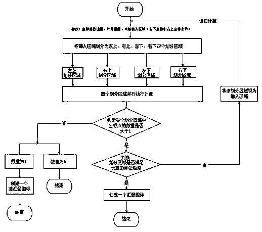
[0045] A method for processing coordinate points of an electronic map interface, the method includes the following steps:

[0046] S1. Steps to divide the input area: divide the electronic map area of ​​the input electronic map interface into four divided areas: upper left, upper right, lower left, and lower right, and create the corresponding four coordinate point data set modules, LTCollection module, RTCollection module, The LBCollection module and the RBCollection module are used to save the coordinate point information of each divided area and the length and width information of each divided area;

[0047] S2. The step of dividing the input coordinate points: traverse all the coordinate points in the electronic map area of ​​the input electronic map interface, and divide them into four coordinate point data set modules according to the position information of the coordinate points (such as the longitude and latitude information of the coordinate points), LTCollection module, R...

Embodiment 2

[0066] The present invention is often used in GIS systems, and the modules include coordinate aggregation algorithm component (Core.Convergenced), aggregate coordinate and non-aggregated coordinate state management component (MarkerManger), raw data loading management component (DataProvider), aggregation auxiliary method component (ConvergencedHelp), customer End event listener component (ClienEventHandler), and finally use the facade mode to encapsulate the above five modules to provide a unified method call class (ConvergencedService). The coordinate aggregation model is to provide data type support for the four-divided icon aggregation function module.


PUM


Abstract

The invention discloses a coordinate point processing method for an electronic map interface and a coordinate point processing device for the electronic map interface. The coordinate point processing method used for aggregating four grid coordinates of GIS (Geographic Information System) service comprises the following steps: S1, setting coordinate point data set modules and algorithm granularity; S2, partitioning coordinate points of an input area; S3, determining the number of the coordinate points in each coordinate point data set module; S4, determining whether the current partition area meets the requirement of the algorithm granularity, and aggregating the coordinates. According to the invention disclosed by the invention, for uneven distribution of the coordinate points, the problem of large calculation amount is solved, meanwhile, problems, such as low computational efficiency and relatively long time consumption, of the traditional method used in the past for relatively large occupied memory are solved by adopting of the method provided by the invention.

Description

Technical field [0001] The invention belongs to the application field of GIS (Geographic Information System), and specifically is a coordinate point processing method and device used for an electronic map interface. Background technique [0002] At present, Gis (Geographic Information Service System) icon aggregation is a method used to solve a large number of positioning coordinate points appearing on the map at the same time. According to the longitude and latitude of the coordinate points, multiple icons close together are gathered into a single icon. Commonly used in various Gis maps, such as Baidu map, Google map, Gaode map, etc. [0003] The current mainstream aggregation method is implemented by the grid method, that is, a surface is divided into several cells according to rows and columns, and all the icons in each cell are gathered into one. The disadvantage of the grid is that the code is relatively complex and long. Using loop traversal grid calculation, time and space ...

Claims


Application Information

Patent Timeline
Patent Type & Authority Patents(China)
IPC IPC(8): G06F17/30
CPCG06F16/29
Inventor 孙晟吉
Owner JIANGSU HONGXIN SYST INTEGRATION
Learn More