GPS navigation path optimization method considering vehicle types and level crossing delay

A technology of GPS navigation and plane crossing, applied in the field of route optimization

Active Publication Date: 2016-05-11
CHANGAN UNIV
View PDF10 Cites 24 Cited by
  • Summary
  • Abstract
  • Description
  • Claims
  • Application Information

AI Technical Summary

Problems solved by technology

Due to the signal control at the intersection and the queuing phenomenon caused by congestion, there will inevitably be a time delay when the vehicle travels to the intersection.

Method used


Image

  • GPS navigation path optimization method considering vehicle types and level crossing delay
  • GPS navigation path optimization method considering vehicle types and level crossing delay
  • GPS navigation path optimization method considering vehicle types and level crossing delay

Examples


Embodiment

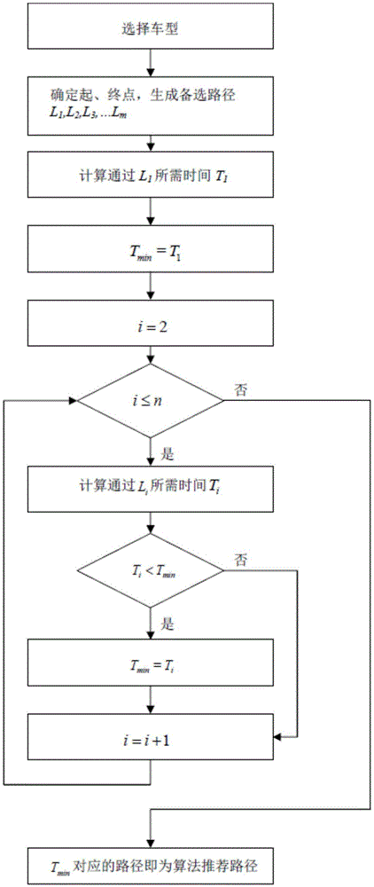
[0241] Step 1: Select the car model, select the passenger car, the starting delay time of the passenger car is 1.5s, and the starting acceleration is 1m / s 2 , refer to Table 2 for the speed limit on each road section.

[0242] Step 2: Determine the starting point A and the ending point B, and the vehicle-mounted GPS provides alternative routes I, II, and III.

[0243] Step 3: Calculate the time T required to pass through routes I, II, and III 1 , T 2 , T 3 . Specifically include:

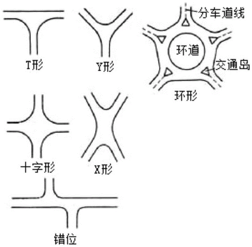
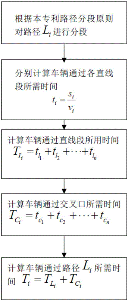
[0244] (1) According to the path segmentation principle proposed in the present invention, the road is segmented, see Figure 7 ;

[0245] (2) Calculate the time T required for the vehicle to pass through the straight road section L ,As shown in table 2;

[0246] Table 2. Passing time of straight line section

[0247] road section

Length / km

Speed ​​limit / (km / h)

number of lanes

Passing time / min

S A‐1

0.1

30

Two-way four-lane

0.2

S 1‐2

...


PUM


Abstract

The invention discloses a GPS navigation path optimization method considering vehicle types and level crossing delay. The method comprises 1) selecting a vehicle type; 2) selecting a starting point and an end point; 3) respectively calculating the time T1, T2, T3,..., Tm needed for a vehicle to pass the path L1, L2, L3,..., Lm, and calculating the time Ti need for a vehicle to pass the path Li; and 4) comparing T1, T2, T3,..., Tm, and obtaining the shortest time Tmin, wherein the path corresponding to Tmin is the path which is recommended by a navigator. The GPS navigation path optimization method considering vehicle types and level crossing delay has the advantages of improving the accuracy for calculating the navigation time by considering the vehicle type and the time that the vehicle passes the crossing so as to influence the accuracy and the result for selection of a navigation path.

Description

technical field [0001] The invention relates to a path optimization method, in particular to a GPS navigation path optimization method considering vehicle types and level intersection delays. Background technique [0002] With the increase of the number of motor vehicles, the phenomenon of urban congestion is becoming more and more serious. Since the first vehicle-mounted GPS appeared in 1990, vehicle-mounted GPS has developed rapidly and matured day by day. Today, vehicle GPS technology is well established and widely used. How to further improve the accuracy of vehicle GPS navigation has become an inevitable problem for its continued development. Due to the signal control at the intersection and the queuing phenomenon caused by congestion, there will inevitably be a time delay when the vehicle travels to the intersection. Therefore, it is very necessary to take intersection delay as one of the considerations when making route selection. [0003] When the car navigator p...

Claims


Application Information

Patent Timeline
Patent Type & Authority Applications(China)
IPC IPC(8): G08G1/0968G01C21/34
CPCG08G1/0968G01C21/3492
Inventor 陈涛刘卡许利峰余经历李栋王杰
Owner CHANGAN UNIV
Why Eureka
Try Eureka