Method and device for detecting lane lines on road surface

A technology of lane line detection and detection method, applied in the field of information detection, can solve the problems of high labor cost, stay, difficult to control accuracy, etc., and achieve the effect of saving labor cost and improving integrity and accuracy

Active Publication Date: 2016-06-22
BAIDU ONLINE NETWORK TECH (BEIJIBG) CO LTD
View PDF5 Cites 57 Cited by
  • Summary
  • Abstract
  • Description
  • Claims
  • Application Information

AI Technical Summary

Problems solved by technology

The disadvantages of this detection method are: it is difficult to draw three-dimensional lines such as lane lines on the three-dimensional point cloud, the lines are obviously distorted, it is difficult to control the accuracy, and the efficiency of manual work is low; Lane lines are missed; in addition, labor

Method used


Image

  • Method and device for detecting lane lines on road surface
  • Method and device for detecting lane lines on road surface
  • Method and device for detecting lane lines on road surface

Examples


Embodiment 1

[0029] see Figure 1a , is a flow chart of a method for detecting lane lines on a road provided by Embodiment 1 of the present invention. The method of the embodiment of the present invention can be executed by a detection device configured with hardware and / or software for lane markings on the road surface, and the implementation device is typically configured in a device capable of providing lane marking detection services.

[0030] The method includes:

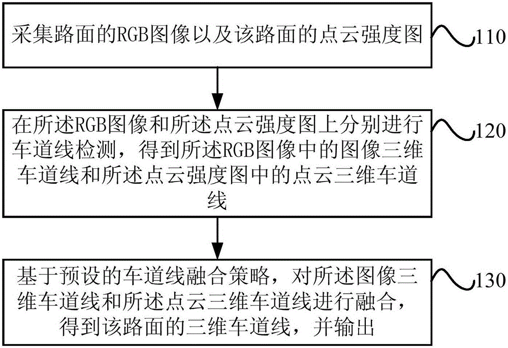
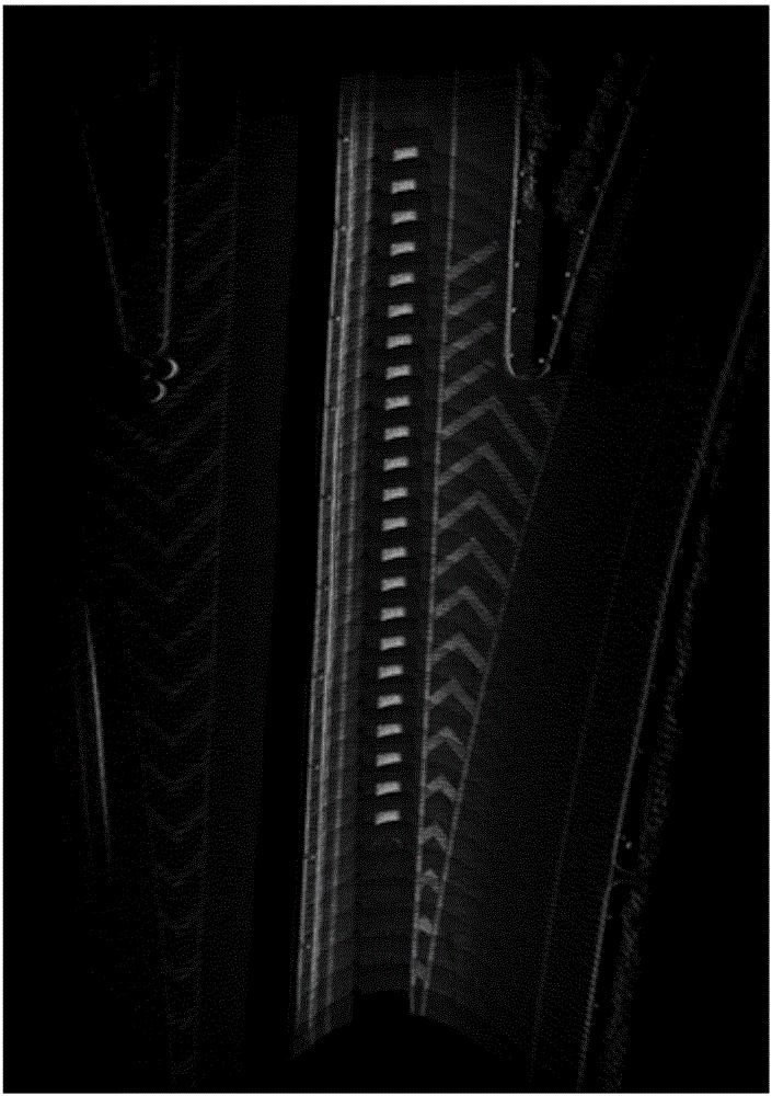
[0031] 110. Collect the RGB image of the road surface and the point cloud intensity map of the road surface.

[0032] In this operation, the RGB image of the road surface and the point cloud intensity map of the road surface are collected synchronously. Specifically, a device for collecting the RGB image (such as an industrial camera) and a device for collecting the point cloud intensity map (such as a radar) may be configured on the collection vehicle to realize synchronous collection.

[0033] The device for collecting ...

Embodiment approach

[0036] As an implementation of the operation of performing lane line detection on the RGB image to obtain the image three-dimensional lane line in the RGB image, it may specifically include:

[0037] Using a deep neural network model to perform lane line detection on the RGB image to obtain a two-dimensional lane line in the RGB image;

[0038] Three-dimensional projection is performed on the two-dimensional lane lines in the RGB image to obtain the three-dimensional lane lines in the RGB image as the image three-dimensional lane lines.

[0039] Wherein, the deep neural network model is obtained by learning and training sample RGB images containing marked two-dimensional lane lines.

[0040] Three-dimensional projection refers to, using the internal reference information of the device that collects the RGB image, the acquisition track recorded during the acquisition process of the RGB image and the point cloud intensity map, and the acquisition track recorded during the acquis...

Embodiment 2

[0062] see Figure 2a , is a flow chart of a method for detecting lane lines on a road provided by Embodiment 2 of the present invention. On the basis of the above-mentioned embodiments, this embodiment provides a preset lane line fusion strategy to fuse the three-dimensional lane line of the image and the three-dimensional lane line of the point cloud to obtain the three-dimensional lane line of the road surface, and output The preferred option for this operation.

[0063] The method includes:

[0064] 210. Collect an RGB image of the road surface and a point cloud intensity map of the road surface.

[0065] In this operation, the RGB image of the road surface and the point cloud intensity map of the road surface are collected synchronously. For details, refer to operation 110 in the foregoing embodiment, and details are not repeated here.

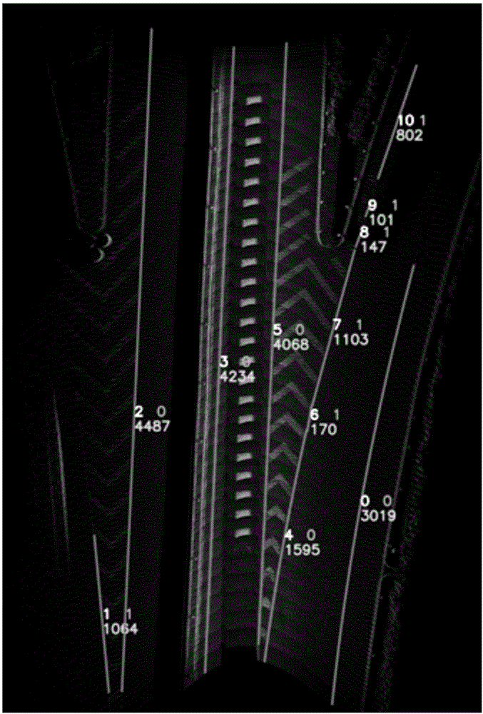
[0066] 220. Perform lane line detection on the RGB image and the point cloud intensity map respectively, to obtain image three-dimen...


PUM


Abstract

An embodiment of the invention provides a method and device for detecting lane lines on a road surface. The method includes the steps of: collecting an RGB image of a road surface and a point cloud intensity map of the road surface; performing lane line detection on the RGB image and the point cloud intensity map respectively, thereby obtaining image three-dimensional lane lines in the RGB image and point cloud three-dimensional lane lines in the point cloud intensity map; and based on a preset lane line fusing strategy, fusing the image three-dimensional lane lines and the point cloud three-dimensional lane lines, thereby obtaining three-dimensional lane lines of the road surface, and outputting the three-dimensional lane lines. By fusion of a lane line detection result of the RGB image and a lane line detection result of the point cloud intensity map, shielding of the road surface lane lines by other vehicles and wear of the lane lines on the road surface and road surface direction arrows can be effectively resisted in most cases, integrity and precision of geometric outlines of the obtained three-dimensional lane lines of the road surface are improved, and in addition, manpower cost is saved.

Description

technical field [0001] Embodiments of the present invention relate to the technical field of information detection, and in particular to a method and device for detecting lane lines on a road surface. Background technique [0002] Three-dimensional high-precision maps are the main development direction of the next generation of digital maps. They are the prerequisites for realizing automatic driving and assisted driving, and provide the main basis for precise positioning and correct decision-making of autonomous or assisted driving vehicles. The core issue of 3D high-precision map production focuses on the detection of lane information on the road surface, that is, the accurate reconstruction of lane information in the real world with a 3D digital map, and the detection technology of lane lines on the road surface came into being. [0003] Currently, there are mainly two detection methods. [0004] Method 1: Artificial production method. Comparing the RGB image of the road...

Claims


Application Information

Patent Timeline
IPC IPC(8): G06K9/00G01B11/24
CPCG01B11/24G06V20/588
Inventor 晏涛蒋昭炎王睿索晏阳
Owner BAIDU ONLINE NETWORK TECH (BEIJIBG) CO LTD
Why Eureka
Try Eureka