GIS space analysis based dividing method for cultural heritage protection divisions

A technology of spatial analysis and cultural heritage, applied in instruments, data processing applications, computing, etc., can solve problems such as low efficiency, poor operability, lack of scientific effectiveness, etc., to save work time and improve work efficiency.

Inactive Publication Date: 2016-06-29
徐震
View PDF2 Cites 13 Cited by
  • Summary
  • Abstract
  • Description
  • Claims
  • Application Information

AI Technical Summary

Problems solved by technology

[0004] The present invention aims to solve the problems of the lack of scientifically effective, standard and standardized technical method system in the process of delineation of protected areas of cultural relics protection units and the resulting confusion of protected area division results, poor operability, and low efficiency.

Method used


Image

  • GIS space analysis based dividing method for cultural heritage protection divisions
  • GIS space analysis based dividing method for cultural heritage protection divisions
  • GIS space analysis based dividing method for cultural heritage protection divisions

Examples


Embodiment Construction

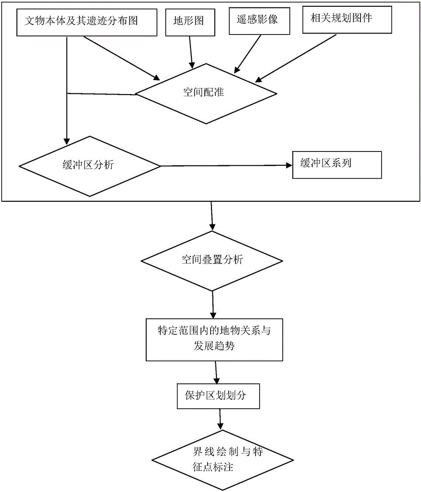
[0019] Describe in detail the method for dividing the cultural heritage protection area based on GIS spatial analysis provided by the present invention in conjunction with accompanying drawings: it comprises the following steps:

[0020] (1) Calibration of spatial data related to cultural heritage

[0021]The division of cultural heritage protection areas involves a large amount of spatial data such as the cultural relics itself and its surrounding environmental characteristics. These spatial data are the basis for the division of cultural heritage protection units. Therefore, it is necessary to collect and sort out large-scale regional topographic maps, multi-period remote sensing images, relic distribution maps, and related planning maps related to the future protection of heritage, such as land planning maps and urban planning maps, that contain cultural relics ontology information. These basic spatial data need to be endowed with a unified spatial standard for subsequent s...


PUM


Abstract

The invention discloses a GIS space analysis based dividing method for cultural heritage protection divisions. The method comprises that 1) different types of maps needed to divide the protection divisions are collected and arranged, and unified registration and correction are carried out in a GIS basic platform; 2) buffer area analysis is carried out on cultural heritage and relic distribution thereof, and space information of buffer areas in different distances from a cultural relic is obtained; 3) a result of buffer area analysis is overlapped with an area topographic map, a remote sensing image and related program maps, basic space information of ground features in different buffer area ranges is extracted, and systematic analysis is carried out on the space relation and development trend of the related ground features; and 4) concrete range and boundary lines of the cultural heritage protection divisions are determined according to an analysis result, computer-aided mapping is used for drafting, and coordinates of the characteristic points in the boundary lines of the protection divisions are calculated with support of GIS, and the characteristic points are marked automatically. According to the invention, accurate space attributes are provided for space data in all the processes and results.

Description

technical field [0001] The invention belongs to the technical field of cultural relics protection, and specifically relates to a method for scientifically and effectively dividing the protection zones of cultural relics protection units by using GIS (Geographic Information System) spatial analysis. Background technique [0002] Cultural heritage is a cultural relic, which is the precious wealth left to us by our ancestors. It is our unshirkable responsibility and obligation to scientifically manage and effectively protect it. The "Law of the People's Republic of China on the Protection of Cultural Relics" requires that there must be a certain safe area outside the cultural relic itself, that is, the protection zone, which generally includes two levels of protection scope and construction control zone. The scope of protection and the construction control zone are two important regionalization concepts, and their delineation is an important means for the effective protection o...

Claims


Application Information

Patent Timeline
Patent Type & Authority Applications(China)
IPC IPC(8): G06Q50/26
CPCG06Q50/26
Inventor 鲁鹏田燕陈盼盼宋立生
Owner 徐震
Why Eureka
Try Eureka