Multimodal depth learning-based remote sensing image classification method

A remote sensing image and deep learning technology, applied in the field of image processing, can solve problems such as low classification accuracy, and achieve the effects of improving classification accuracy, reducing manual input, and simplifying complexity

Active Publication Date: 2016-09-07
SHANGHAI OCEAN UNIV
View PDF2 Cites 28 Cited by
  • Summary
  • Abstract
  • Description
  • Claims
  • Application Information

AI Technical Summary

Problems solved by technology

[0005] The purpose of the present invention is to address the deficiencies in the prior art, to provide a remote sensing image classification method based on multimodal deep learning, to solve the problem of low classification accuracy caused by manual extraction of low-level features and the limitation of information contained in sin

Method used


Image

  • Multimodal depth learning-based remote sensing image classification method
  • Multimodal depth learning-based remote sensing image classification method
  • Multimodal depth learning-based remote sensing image classification method

Examples


Embodiment Construction

[0031] The specific embodiments provided by the present invention will be described in detail below in conjunction with the accompanying drawings.

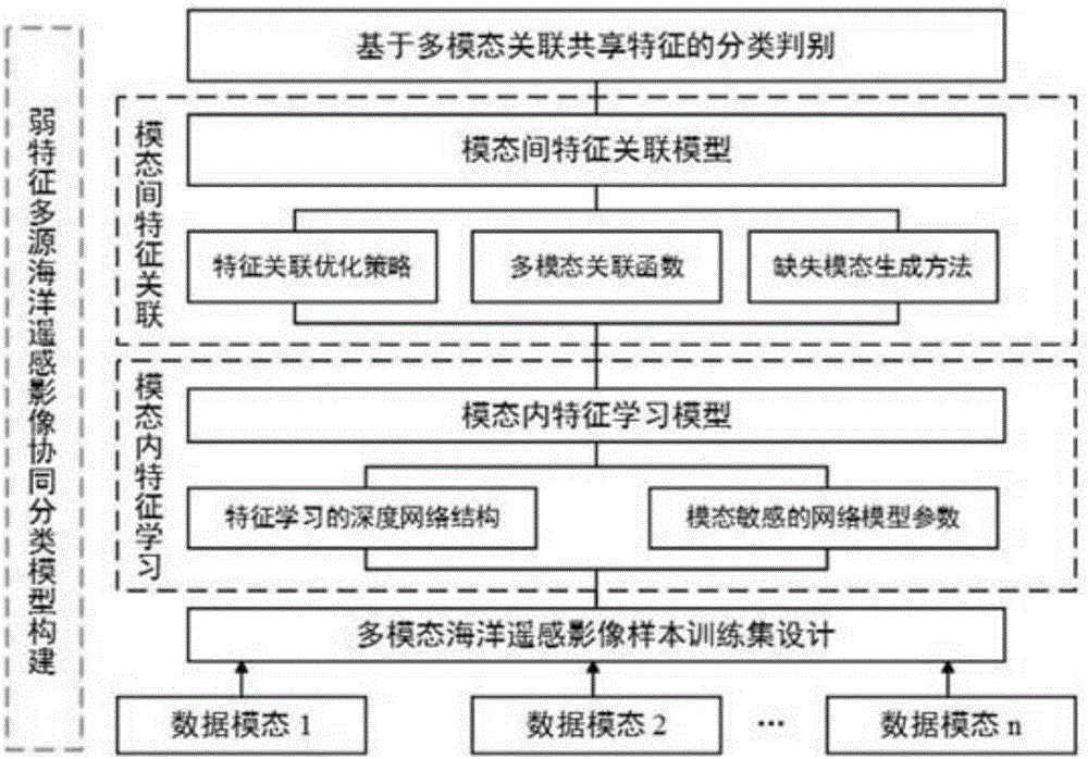
[0032] The present invention is a remote sensing image classification method based on multimodal deep learning, such as figure 1 shown, including the following steps:

[0033] Step 1: Construct a multi-modal sample set, and design the size of remote sensing images under different data modes according to different data modes;

[0034] The sample set includes different data modalities, and the sample size of each data modality is designed in different sizes according to different imaging principles such as its space and spectral resolution.

[0035] Specifically, for the same surface object to be classified, taking two data modalities as an example, the spatial resolutions of the two remote sensing images are h and h' respectively, and the sample size of the remote sensing image with resolution h is set to N×N, then The sample siz...


PUM


Abstract

The invention discloses a multimodal depth learning-based remote sensing image classification method. The method includes the following steps that: a multimodal remote sensing image data sample set is constructed, wherein the multimodal remote sensing image data sample set includes multimodal remote sensing images which are formed based on different imaging principles; data modal sensitive feature learning depth networks are constructed, and different modal data are adopted to train corresponding feature learning depth networks; an inter-modal feature correlation model is constructed, correlation sharing features are generated and trained; and a test sample set is inputted into a trained and finely-tuned multimodal depth network, so that precise classification of the remote sensing images can be realized. With the multimodal depth learning-based remote sensing image classification method adopted, multi-source remote sensing images are effectively utilized; inter-modal complementary and cooperation information is mined; a whole process is executed automatically; low classification precision caused by artificial input and subjective human factors is avoided; and classification precision is improved.

Description

technical field [0001] The invention relates to the technical field of image processing, in particular to a remote sensing image classification method based on multimodal deep learning. Background technique [0002] Classification is an important basis for the application of remote sensing image analysis. Based on the multi-platform, multi-spectrum, and multi-channel continuous observation of the ocean, the "star-machine-earth" three-dimensional observation network has spawned multi-scale, multi-temporal, multi-azimuth, and multi-level ocean remote sensing images, providing a richer and more accurate description of ground objects. data information. There is information complementarity and cooperation among multi-source remote sensing images. Using two or more remote sensing data sources to extract information can obtain higher extraction accuracy than using any one of the remote sensing data sources alone. Therefore, the abundant and available multi-source remote sensing i...

Claims


Application Information

Patent Timeline
IPC IPC(8): G06K9/62
CPCG06F18/2413
Inventor 黄冬梅杜艳玲贺琪宋巍石少华苏诚
Owner SHANGHAI OCEAN UNIV
Why Eureka
Try Eureka