Geological map thematic information extraction method

A technology of thematic information and extraction methods, applied in geographic information databases, image data processing, still image data retrieval, etc., can solve the problems of poor vectorization effect and inability to achieve practical effects, and achieve the effect of reducing noise

Inactive Publication Date: 2016-09-07
CHINA UNIV OF GEOSCIENCES (BEIJING)
View PDF3 Cites 25 Cited by
  • Summary
  • Abstract
  • Description
  • Claims
  • Application Information

AI Technical Summary

Problems solved by technology

The current vectorization software on the market can only handle relatively simple images. For the overlapping and overlapping of various elements in the geological map, the vectorization effect is very poor, and it cannot achieve practical results at all.

Method used


Image

  • Geological map thematic information extraction method
  • Geological map thematic information extraction method
  • Geological map thematic information extraction method

Examples


Embodiment Construction

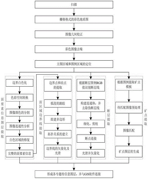
[0031] A geological map image preprocessing method

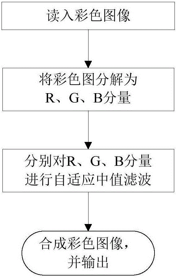
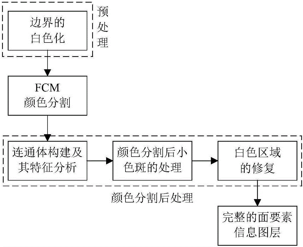
[0032] Geological map image preprocessing methods refer to preprocessing methods such as geometric correction of geological map images, color image denoising, and positioning of main map areas and legend areas.

[0033] Specifically:

[0034] 1 Geometry Correction

[0035] STEP 1: For any point in the distorted image (x i ,y i ), according to the relationship between the original image coordinate system and the distorted image coordinate system Find the corresponding point in the corresponding distorted image (xu i ,yu i )=[h 1 (x i ,y i ), h 2 (x i ,y i )];

[0036] STEP 2: Since usually, (xu i ,yu i ) is not an integer point, so the bilinear interpolation method is used to find out the sum (xu i ,yu i ) to the nearest integer point (x′ i ,y′ i ). According to the distorted image (x i ,y i ) at the gray value of the 4 pixels in the 4-neighborhood, the gray value g(x i ,y i ) calculation formula Amo...


PUM


Abstract

According to the legend information, in view of the different characteristics of the color, shape, texture and spatial relationship of various elements on a geological map, techniques of color segmentation, boundary tracking, and mode identification are adopted to extract the main information, e.g. stratum, magmatite, construction, or ore occurrence, related to mineral products in the geological map to form a thematic information graph layer. The geological map thematic information extraction method includes a geological map data preprocessing method, a geological map thematic information extraction method, and an information output method. The method aims to solve the difficulty in geological map information extraction, namely, takes a semi-structured standard geological map as a research object and the geological map information extraction as objective, and extracts the main information, e.g. stratum, magmatite, construction, or ore occurrence, related to the mineral products in the geological map through the combination with legend information to construct the thematic information graph layer, thereby forming a set of techniques for converting the semi-structured data (image) into structure data.

Description

technical field [0001] The present invention relates to a method for extracting thematic information of geological maps, in particular to a method for automatically extracting the main information related to minerals contained in geological maps in grid format (JPG, TIFF, etc.) and forming vector thematic information layers method. Background technique [0002] Thematic information refers to a certain type of information in geological maps, such as strata, magmatic rock bodies, alteration zones, faults, geological boundaries, ore points, etc. [0003] Image geometric correction refers to correcting and eliminating the deformation caused by various factors when the geometric position, shape, size and other characteristics of the objects on the original image are inconsistent with the expression requirements in the reference system through a series of mathematical models (such as Scaling, rotation, translation, affine and other geometric distortions), the process of obtaining...

Claims


Application Information

Patent Timeline
Patent Type & Authority Applications(China)
IPC IPC(8): G06T17/05G06F17/30
CPCG06F16/29G06F16/56G06F16/5838G06T17/05
Inventor 陈建平徐彬徐炀郑啸
Owner CHINA UNIV OF GEOSCIENCES (BEIJING)
Why Eureka
Try Eureka