Building information modeling (BIM) augmented reality lofting system based on electronic total station and photogrammetric technology

An augmented reality and photogrammetry technology, applied in the field of surveying, can solve the problems such as failure to calculate the absolute coordinates and posture of augmented reality equipment, low efficiency and accuracy of multi-marker arrangement, affecting the practice and application of augmented reality technology, etc. Eliminate manual operation, ensure high efficiency and accuracy, high degree of automation and high degree of intuition

Active Publication Date: 2016-10-12
廖卫东
View PDF6 Cites 35 Cited by
  • Summary
  • Abstract
  • Description
  • Claims
  • Application Information

AI Technical Summary

Problems solved by technology

The requirement of measuring multiple data for each marker and the characteristics of total station measurement technology make the layout of multiple markers inefficient and inaccurate, which affects the promotion of IO-based marked augmented reality technology
[0010] The OI-based augmented reality system with markers only realizes the tracking of the relative displacement and attitude angle change of the augmented reality device relative to the tracking scene; the augmented reality system without marker tracking and registration can solve the relative displacement and attitude of the augmented reality camera relative to the natural scene The angle changes, but the camera position and attitude cannot be located by registering the coordinates of the feature points in the natural scene image or the reconstructed scene model in the engineering measurement coordinate system
In essence, a temporary coordinate system is established for each positioning registration, and the absolute coordinates and attitude of the augmented re...

Method used


Image

  • Building information modeling (BIM) augmented reality lofting system based on electronic total station and photogrammetric technology
  • Building information modeling (BIM) augmented reality lofting system based on electronic total station and photogrammetric technology
  • Building information modeling (BIM) augmented reality lofting system based on electronic total station and photogrammetric technology

Examples


Embodiment 1

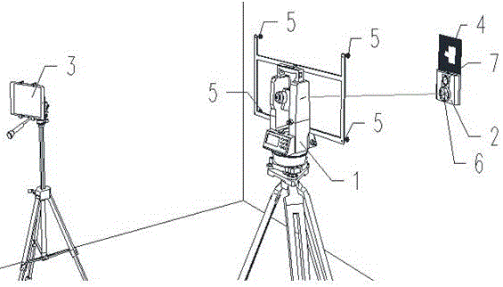
[0027] like figure 1 As shown, a BIM augmented reality stakeout system based on a total station and photogrammetry technology includes a total station 1 , a positioning device 2 , an augmented reality device 3 and a marker 4 . Four optical marking points 5 are set on the total station, and these four points form a rectangle. The positioning device includes a prism 6 and a camera 7 . The function of the prism 6 is to reflect the range-finding infrared light or laser light emitted by the distance measuring equipment of the total station. Of course, some total stations do not need the prism 6 .

[0028] When locating the initial coordinates and attitude of the marker, the positioning device and the marker are closely connected to ensure that the relative coordinates and attitude of the two remain unchanged. Furthermore, as long as the posture and coordinates of the positioning device are obtained, the posture and coordinates of the marker can be calculated according to the rela...

Embodiment 2

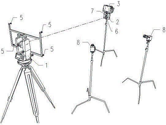
[0039] like image 3 As shown in the figure, a BIM augmented reality staking system based on total station and photogrammetry technology includes a total station 1, a positioning device 2, an augmented reality device 3, and a tracking camera 8 (the outer and inner OI tracking system was described above, this is the For this specific form of the system, the tracking optical camera is stationary and the marker is mounted on the tracked object). Four optical identification points 5 are set on the total station, and the four points form a rectangle. The positioning device includes a prism 6 and a camera 7 .

[0040] When positioning the initial coordinates and attitude of the augmented reality device, the positioning device 2 and the augmented reality device 3 are closely connected by a fixing device to ensure that the relative coordinates and attitude of the two remain unchanged.

[0041] The positioning device 2 calculates the three-dimensional coordinates and attitude of the ...

Embodiment 3

[0044] like image 3 As shown, another implementation structure of a BIM augmented reality stakeout system based on a total station and photogrammetry technology includes a total station 1 , a positioning device 2 , and an augmented reality device 3 . Four optical identification points 5 are set on the total station, and the four points form a rectangle. The positioning device includes a prism 6 and a camera 7 .

[0045] The implementation method of the initial coordinates and posture of the augmented reality device 3 in the engineering measurement coordinates is the same as that of Example 2. The no-mark tracking registration system in the augmented reality device 3 uses natural scene images or reconstructed scene models (such as SLAM technology), and calculates the coordinates and posture increments of the augmented reality device 3 according to the 2D projection images of the target features obtained in each frame of the camera. The real-time absolute coordinates and post...


PUM


Abstract

The invention relates to a measuring technology, and discloses a building information modeling (BIM) augmented reality lofting system based on an electronic total station and a photogrammetric technology. The BIM augmented reality lofting system comprises an augmented reality device, the electronic total station, a positioning device and a to-be-measured marker, wherein the to-be-measured marker or the augmented reality device is fixed with the positioning device; at least four optical identification points are arranged on on the electronic total station; the positioning device comprises a camera; the camera is used for acquiring images of the optical identification points, arranged on the electronic total station, in the camera, calculating the relative attitudes of the optical identification points and the positioning device, and calculating the attitude of the positioning device in an engineering measurement coordinate system according to the relative attitudes of the optical identification points and the positioning device; the electronic total station is used for acquiring coordinates of the positioning device; the augmented reality device is used for calculating the coordinates, elevation and attitude of the to-be-measured marker or the augmented reality device in the engineering measurement coordinate system according to the relative distance and attitude of the to-be-measured marker or the augmented reality device and the positioning device, thus realizing fusion of coordinates.

Description

technical field [0001] The invention relates to measurement technology, in particular to a BIM augmented reality lofting system based on total station and photogrammetry technology. Background technique [0002] BIM is the abbreviation of Building Information Modeling, which is usually translated as Building Information Modeling. BIM is an information management technology for the whole life cycle of a building, which has five characteristics of visualization, coordination, simulation, optimization and drawing. BIM is a brand-new method of architectural design, construction, and management. Based on three-dimensional digital information technology, all data in planning, design, construction, and operation stages are included in the 3D model, allowing the entire life cycle of the building to When using the model, workers at any stage in the process can make effective and correct decisions based on accurate and complete data. [0003] At present, the 3D model of BIM can only...

Claims


Application Information

Patent Timeline
IPC IPC(8): G01C15/00
CPCG01C15/002
Inventor 廖卫东
Owner 廖卫东
Why Eureka
Try Eureka