
Method for extracting surface peaks in DEM data

An extraction method and technology of mountain tops, applied in image data processing, instruments, calculations, etc., can solve problems such as incomplete recognition of mountain tops, not fully conforming to the definition of mountains, and appearance of mountain tops, etc., to achieve false mountain tops and mountain tops The effect of less omission, concise algorithm and precise position

Active Publication Date: 2016-10-19
XI'AN UNIVERSITY OF ARCHITECTURE AND TECHNOLOGY
View PDF2 Cites 18 Cited by
  • Summary
  • Abstract
  • Description
  • Claims
  • Application Information

AI Technical Summary

Problems solved by technology

[0004] To sum up, the research on the extraction of mountain tops has received extensive attention, and there are many extraction algorithms. However, due to the complex and changeable terrain of mountainous areas, the shape of mountains is also very different, and people's understanding of mountain tops is not completely clear. The mountain point extraction algorithm cannot accurately obtain the real mountain point, and will miss the mountain point or appear false mountain points
The peak of a mountain is the highest point in the local field of view, but the highest point in the actual local field of view is not necessarily the top of the mountain, and the peak of the mountain extracted in practical applications does not fully conform to the definition of mountains in geomorphology

Method used


Image

  • Method for extracting surface peaks in DEM data
  • Method for extracting surface peaks in DEM data
  • Method for extracting surface peaks in DEM data

Examples


Embodiment

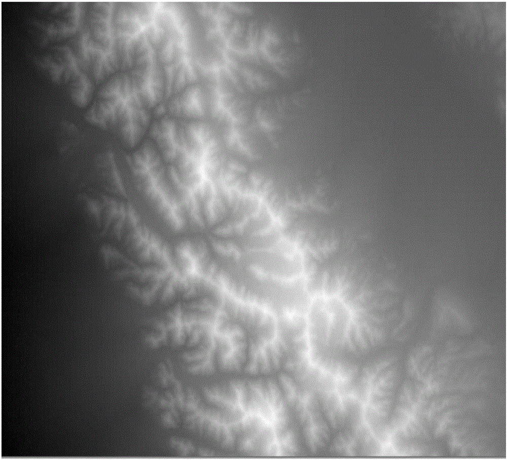
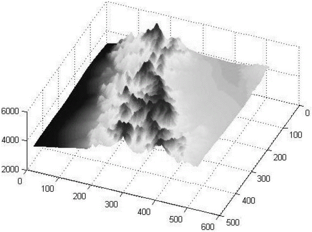
[0067] Based on the 1:250,000 DEM data of the Qilian Mountain area, the data grid accuracy is 90 meters, the elevation range is 2970-5452 meters, the average elevation is 4098 meters, and the maximum relief is 1216 meters. The three-dimensional perspective view and the grayscale rendering are respectively shown in Fig. 2 (a) and Fig. 2 (b) as examples, and the specific embodiments of the present invention are as follows:

[0068] Step 1, use linear interpolation method to extract contour lines from DEM data. First determine the contour distance h, and then use the literature "Bian Shuli. Optimization and implementation of contour extraction algorithm based on regular grid DEM [J]. Surveying and Mapping Science, 2008,33(6):151-157 .” method to extract contour lines.

[0069] Because the maximum terrain relief of the experimental data is 889 meters, according to the literature "Luo Mingliang, Tang Guoan. Peak extraction of landform cognition and spatial division [J]. Surveying ...


PUM


Abstract

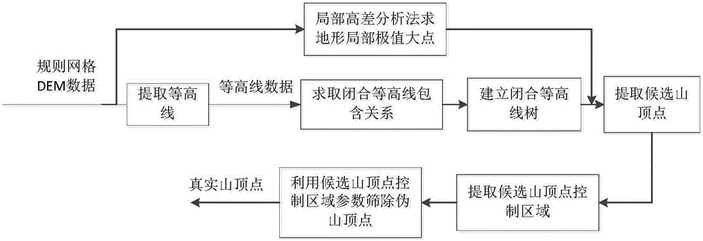
The invention discloses a method for extracting surface peaks in DEM data. The method includes the steps that 1, contour lines are generated in a DEM with a linear interpolation method; 2, closed contour lines are screened from the contour lines, and the inclusion relation between the closed contour lines is solved; 3, a closed contour line tree is built according to the inclusion relation between the contour lines; 4, the DEM and the contour lines are combined to solve primarily-selected surface peaks; 5, control areas of the primarily-selected surface peaks are solved through the contour line tree; 6, the fake surface peaks are removed through the parameters of the control areas of the primarily-selected surface peaks, and the final surface peaks are obtained. According to the method, the primarily-selected surface peaks are extracted through the microscopic features and the contour lines of the DEM data, the accuracy of the spatial positions of the primarily-selected surface peaks is guaranteed, and missing of the surface peaks can be avoided; the control areas of the primarily-selected surface peaks are obtained through the contour line tree, the features of factors related to the terrain of the surface peaks are analyzed in the control areas, the primarily-selected surface peaks are further screened, the fake surface peaks are removed, the true surface peaks are obtained, and the final surface peaks are obtained.

Description

technical field [0001] The invention belongs to the field of digital terrain analysis, and in particular relates to a method for extracting mountain tops in DEM data. Background technique [0002] Digital Terrain Analysis is a digital information processing technology for terrain attribute calculation and feature extraction on DEM data. In geomorphology, a mountain is defined as a highland with an altitude of more than 500 meters, a relative undulation greater than 200 meters, and a steep slope. The mountain is divided into three parts: the top, the slope, and the foothills from top to bottom. The top of the mountain appears as the maximum point of elevation in a certain area. For different landforms, the spatial distribution of the top of the mountain shows a difference in elevation. This difference determines the degree of undulation of the top of the mountain and the difference in the control area. Usually, the top of a mountain is considered as the dynamic surface of mo...

Claims


Application Information

Patent Timeline
IPC IPC(8): G06T7/00
CPCG06T7/0002G06T2207/20164G06T2207/30181
Inventor 孔月萍聂文戚艳军张倩张跃鹏张德
Owner XI'AN UNIVERSITY OF ARCHITECTURE AND TECHNOLOGY
Learn More