Method for parallel space query based on grid division and system of same

A grid division and spatial query technology, applied in special data processing applications, instruments, electrical digital data processing, etc., to reduce data storage space, improve efficiency, and reduce task candidate sets

Active Publication Date: 2016-10-26
FUJIAN AGRI & FORESTRY UNIV
View PDF3 Cites 34 Cited by
  • Summary
  • Abstract
  • Description
  • Claims
  • Application Information

AI Technical Summary

Problems solved by technology

[0007] The technical problem to be solved by the present invention is to provide a parallel space query method and system based on grid division, which can not only effectively solve the problem of boundary object processing generated during space division, but also pre-screen irrelevant spatial objects, significantly improving Parallel Data Analysis Efficiency

Method used


Image

  • Method for parallel space query based on grid division and system of same
  • Method for parallel space query based on grid division and system of same
  • Method for parallel space query based on grid division and system of same

Examples


Embodiment 1

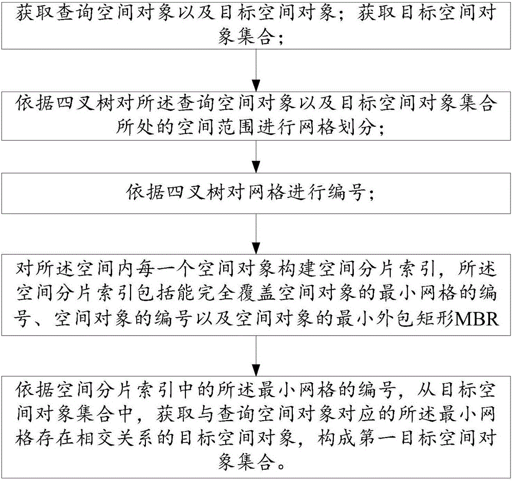
[0090] Please refer to figure 2 , Figure 3(a) to Figure 3(c) , this embodiment provides a parallel spatial query method based on mesh division, and the spatial query may be a join query or a range query. Take the parallel connection query of R and S as an example, assuming that the R is a bus route and the S is a bridge, by performing a parallel connection query on R and S, all bridges intersecting with the bus route are obtained;

[0091] First, determine the query space object and the target space object, that is, the query space object is an arbitrarily designated bus route R1, the target space object is a bridge, and the parallel query condition is that the spatial topology relationship between the two is intersection;

[0092] Then obtain the target spatial object set of the query space, that is, the set of all bridges; for the spatial data set participating in the parallel spatial query, that is, the query spatial object and the target spatial object set, the spatial ...

Embodiment 3

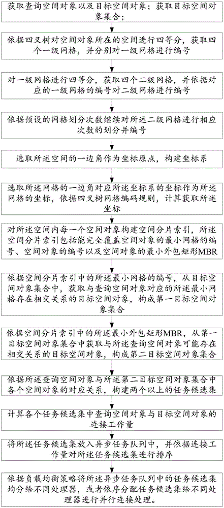
[0134] This embodiment is further extended on the basis of Embodiment 1 and Embodiment 2, and the similarities will not be repeated. The difference lies in the addition of a load balancing distribution scheme based on spatial object-based spatial fragmentation indexes:

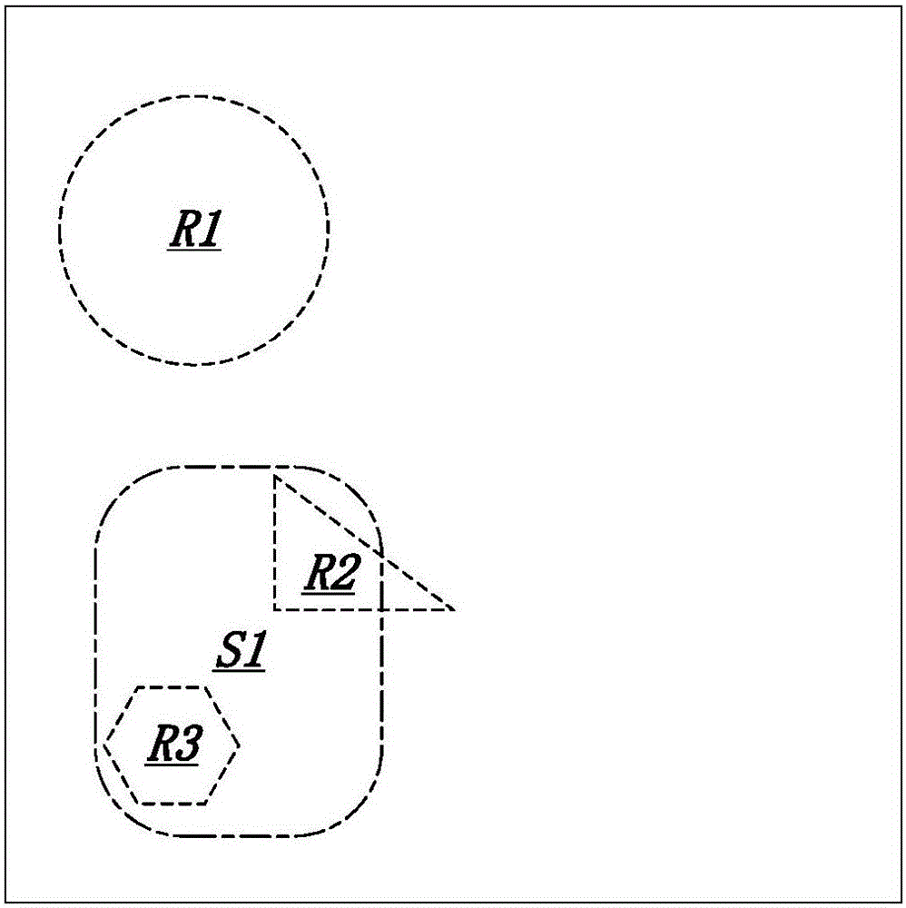
[0135] 1. According to the corresponding relationship between the query spatial object and each spatial object in the second target spatial object set, construct more than two task candidate sets; such as the task candidate set of S1-R2; the task candidate set of S1-R3 ;

[0136] 2. Calculate the connection workload between the query space object and the target space object in each task candidate set, that is, the connection workload Wt from S1 to R1;

[0137] 3. Put the task candidate set into the asynchronous task queue, and sort the task candidate set according to the connection workload; sort the task queue Task with Wt as the key, set Wp=Wsum / N,

[0138] Where Wsum is the total workload, N is the number ...

Embodiment 4

[0144] see Figure 5 , this embodiment provides a grid-based parallel spatial query system corresponding to the parallel spatial query method of Embodiments 1 to 3, specifically including:

[0145] The first acquisition module 1 is used to determine the query space object and the target space object;

[0146] The second obtaining module 2 is used to obtain a target space object set;

[0147] A grid division module 3, configured to perform grid division on the spatial range where the query spatial object set and the second target spatial object set are located according to the quadtree;

[0148] The grid numbering module 4 is used to number the grids according to the quadtree; the grid division module and the grid numbering module can be integrated and realized by a functional module, which specifically includes:

[0149] The first-level division numbering unit 11 is used to quarter the space where the spatial object is located according to the quadtree model, obtain four fir...


PUM


Abstract

The invention provides a method for parallel space query based on grid division and a system of the same. The method comprises the steps that the grid division and numbering are carried out to query space objects and a space scope in which a target space object set is located according to a quad tree; a space fragmented index is constructed for each space object; and according to the number of a minimum grid in the space fragmented index, a target space object which has an intersection relation with the minimum grid corresponding to the query space object is acquired from the target space object set. According to the invention, the quad tree is used for the space grid division and the grid numbering, so that each space object is contained in a corresponding quad tree grid, and thus a boundary object processing problem is eliminated; and meanwhile, according to a space topological relation hidden in a quad tree code, the space objects which obviously cannot satisfy query conditions can be filtered out, so that the candidate target space objects can be pre-filtered, task candidate sets can be reduced, and parallel query efficiency can be increased once again.

Description

technical field [0001] The invention relates to the field of parallel spatial data analysis and processing, in particular to a parallel spatial query method and system based on grid division. Background technique [0002] Today's mainstream GIS geographic information system is still based on serial computing. It is difficult to fully utilize and develop the ability of computer resources in the current new hardware architecture, and it is difficult to meet the scale and efficiency requirements of practical applications. Parallelization has become an important way to improve the efficiency of geographic computing today. For parallel geographic data calculation based on vector data, the difficulties are mostly reflected in space division, task scheduling, and parallel analysis. Spatial task allocation is the basis of parallel spatial query (parallel range query, parallel join query, etc.), and can be divided into two schemes: space declustering and data partition. [0003] Sp...

Claims


Application Information

Patent Timeline
Patent Type & Authority Applications(China)
IPC IPC(8): G06F17/30
CPCG06F16/2246G06F16/29
Inventor 范协裕邱龙霞张黎明
Owner FUJIAN AGRI & FORESTRY UNIV
Why Eureka
Try Eureka