A mobile law enforcement position acquisition and correction method based on wireless communication and satellite models

A mobile law enforcement, satellite model technology, applied in the direction of vehicle position indication, traffic control system, traffic control system of road vehicles, etc., can solve the problems of increasing office expenses, reducing the efficiency of bicycle use, affecting the efficiency of law enforcement, etc., to achieve convenient positioning target, reducing vehicle wear and tear, reducing the effect of vulnerabilities

Active Publication Date: 2019-03-22
ANHUI CHAOYUAN INFORMATION TECH
View PDF6 Cites 2 Cited by
  • Summary
  • Abstract
  • Description
  • Claims
  • Application Information

AI Technical Summary

Problems solved by technology

[0002] At present, most of the mobile law enforcement vehicles launched on the market do not have the function of obtaining law enforcement locations, and the command center cannot know where the law enforcement vehicles have gone, which locations they have passed, and other information, and thus cannot efficiently dispatch and use law enforcement vehicles, and cannot give full play to law enforcement. Resource Utilization of Vehicles
[0003] Although some mobile law enforcement vehicles have the function of obtaining the driving position of the vehicle, because the obtained position data is the latitude and longitude data transmitted by the satellite, and the latitude and longitude data is a kind of spatial position data, for the law enforcement personnel on the road, It is inconvenient to directly use latitude and longitude information for target positioning, which will affect the efficiency of law enforcement
[0004] At present, there is no location information on the expressway law enforcement vehicles that can directly display the "××highway ×× kilometers", and it is difficult for the vehicle administrator to pass the travel requirements, Tasks are sent to drivers in a timely manner to achieve real-time scheduling, which undoubtedly reduces the efficiency of bicycle use and increases related office costs

Method used


Image

  • A mobile law enforcement position acquisition and correction method based on wireless communication and satellite models
  • A mobile law enforcement position acquisition and correction method based on wireless communication and satellite models
  • A mobile law enforcement position acquisition and correction method based on wireless communication and satellite models

Examples


Embodiment 1

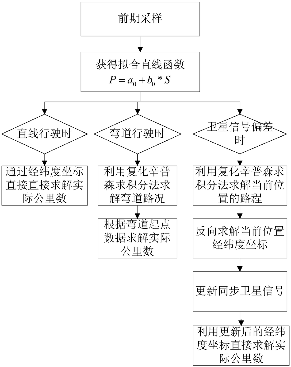
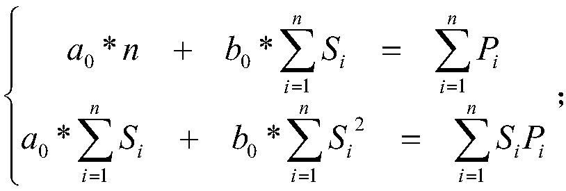
[0051] This embodiment provides a wireless communication and satellite type mobile law enforcement position acquisition and correction method. When a mobile law enforcement vehicle passes through M, the current latitude and longitude coordinates transmitted by the satellite to the background are S m , the latitude and longitude coordinates of the starting point of the expressway is S 0 , put it into the fitting straight line function P=a 0 +b 0 *S, obtain the distance P of the mobile law enforcement vehicle at M and the starting point of the expressway m and P 0 , then the actual distance between the location M and the starting point of the expressway is P'=P m +P 0 ;

Embodiment 2

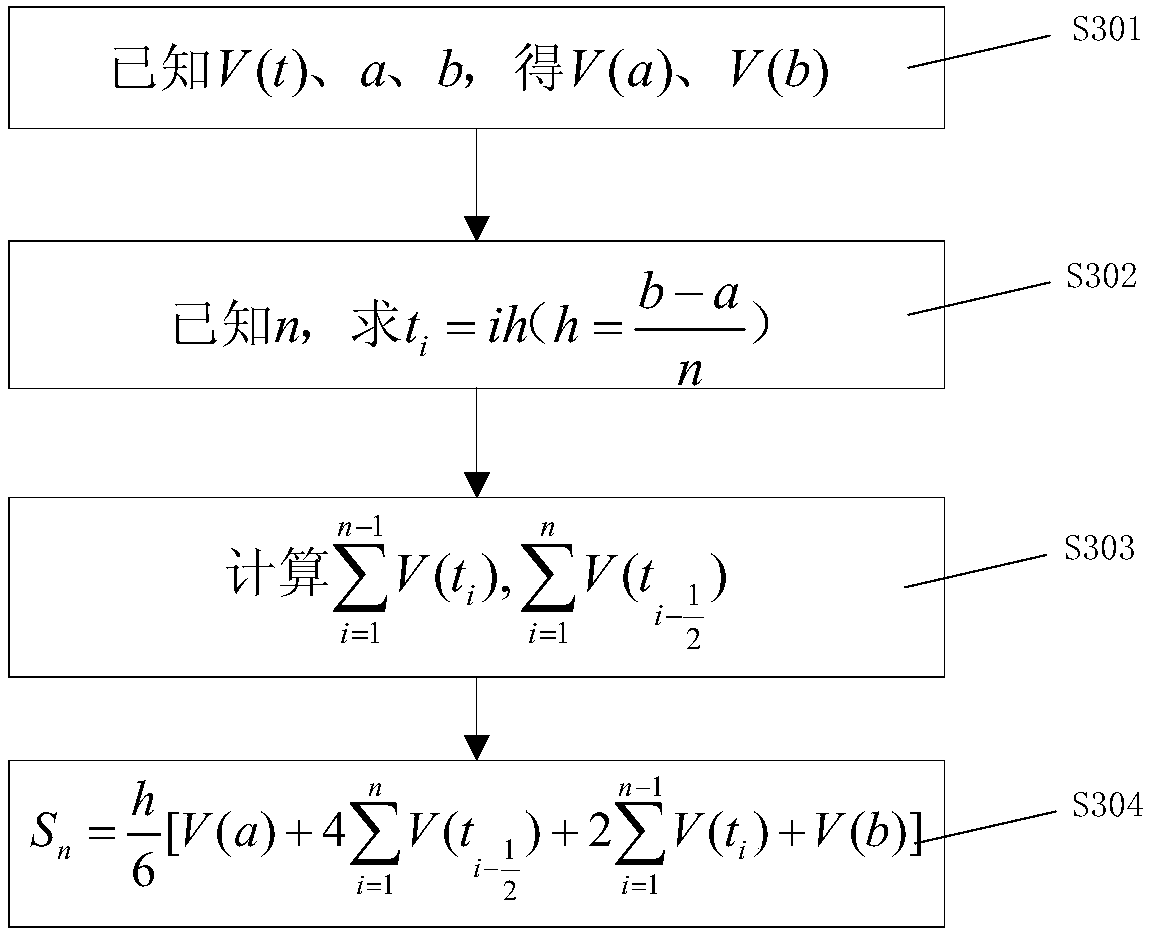
[0053] This embodiment provides a wireless communication and a method for acquiring and correcting the mobile law enforcement position of the satellite model when the mobile law enforcement vehicle enters a curve. The method first uses the complex Simpson integral formula of step (2) to calculate the extremely short In the distance, "substituting straightness for curves" is adopted, and the road conditions of the mobile law enforcement vehicle passing through the curve are approximated by continuously summing the integral values ​​in the small area, and the mobile law enforcement vehicle passes through the curve at a real-time speed of V(t). The actual number of road kilometers traveled on the road P s , and then use the method of step (1) to calculate the actual kilometers P w , then the actual distance between the mobile law enforcement vehicle and the starting point of the expressway intersection when passing the curve P'=P s +P w .

Embodiment 3

[0055] This embodiment provides a method for obtaining and correcting the position of mobile law enforcement of wireless communication and satellite models when the satellite cannot work normally or the transmitted latitude and longitude data has a significant deviation due to weather, network or other signals. In order to first pass the method of step (2), integrate in the [a, b] time period, and then sum in multiple time intervals to obtain the actual kilometers from the starting point of the expressway when the mobile law enforcement vehicle travels to the current position P', P'-P 0 , to obtain the distance P traveled by the mobile law enforcement vehicle when it travels to the current position m , and then according to the above fitting linear function P=a 0 +b 0 *S, reverse solution to obtain the correct latitude and longitude coordinates S of mobile law enforcement vehicles m ; Finally, replace the latitude and longitude information in the satellite with the correct ...


PUM


Abstract

The invention discloses a mobile law enforcement position acquisition and correction method of wireless communication and a satellite model. The method comprises the following steps of through early stage sampling and a least square method, acquiring a fitting line function; calculating an actual mileage of a mobile law enforcement vehicle which is driven from a highway starting position to a current position; for a positioning distortion condition generated when the vehicle passes through a curve road section of the road and a signal deviation condition of a synchronous satellite, using a real-time path ''infinite division'' method of the law enforcement vehicle passing through the curve road section and using a ''replacing curve by straight line'' continuous summation method in each tiny section to relatively accurately calculate a running distance of the vehicle. Compared to the prior art, by using the method of the invention, the actual mileage of the mobile law enforcement vehicle which is driven from a highway starting position can be accurately calculated so that latitude and longitude information is converted into actual and visual ''highway** kilometer'' road information and a police law enforcement worker can conveniently position a target.

Description

technical field [0001] The invention belongs to the technical field of intelligent traffic monitoring, and in particular relates to a method for obtaining and correcting mobile law enforcement positions based on wireless communication and satellite models. Background technique [0002] At present, most of the mobile law enforcement vehicles launched on the market do not have the function of obtaining law enforcement locations, and the command center cannot know where the law enforcement vehicles have gone, which locations they have passed, and other information, and thus cannot efficiently dispatch and use law enforcement vehicles, and cannot give full play to law enforcement. Vehicle resource utilization. [0003] Although some mobile law enforcement vehicles have the function of obtaining the driving position of the vehicle, because the obtained position data is the latitude and longitude data transmitted by the satellite, and the latitude and longitude data is a kind of s...

Claims


Application Information

Patent Timeline
Patent Type & Authority Patents(China)
IPC IPC(8): G08G1/13G08G1/133
CPCG08G1/13G08G1/133
Inventor 邱换春王传根许如峰王孝贵陈岩
Owner ANHUI CHAOYUAN INFORMATION TECH
Why Eureka
Try Eureka