Quick splicing method for remote sensing image of unmanned aerial vehicle
A fast splicing and machine remote sensing technology, applied in the field of UAV remote sensing, can solve the problems of cumbersome procedures, low matching accuracy, and inability to meet real-time splicing, and achieve good splicing effect, high matching accuracy, and high splicing efficiency.
- Summary
- Abstract
- Description
- Claims
- Application Information
AI Technical Summary
Problems solved by technology
Method used
Image
Examples
Embodiment Construction
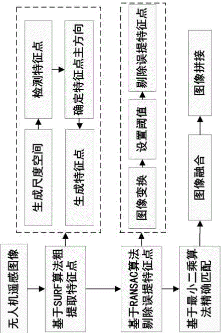
[0043] Such as figure 1 As shown, a kind of unmanned aerial vehicle remote sensing image splicing method of the present invention comprises the following steps:
[0044] (1) Roughly extract feature points based on the SURF algorithm: first generate the scale space, then detect the feature points, then determine the main direction of the feature points, and finally generate the feature points;
[0045] (2) Use the RANSAC algorithm to eliminate the mis-extracted feature points: first perform image transformation, then set the threshold, and finally delete the mis-extracted feature points;
[0046] (3) Use the least squares matching method to accurately match the image feature points;
[0047] (4) Perform linear weighted average image fusion;
[0048] (5) Stitching the images to get the UAV remote sensing image.
[0049] The specific process of step (1) is,
[0050] On the reference image and the image to be matched, select box filters of different sizes to establish the scal...
PUM
 Abstract
Description
Claims
Application Information
 - R&D
- Intellectual Property
- Life Sciences
- Materials
- Tech Scout
- Unparalleled Data Quality
- Higher Quality Content
- 60% Fewer Hallucinations
Browse by: Latest US Patents, China's latest patents, Technical Efficacy Thesaurus, Application Domain, Technology Topic, Popular Technical Reports.
© 2025 PatSnap. All rights reserved.Legal|Privacy policy|Modern Slavery Act Transparency Statement|Sitemap|About US| Contact US: help@patsnap.com

