Under-the-cloud pixel LST estimation method based on microwave remote sensing and space-time information

A remote sensing and pixel technology, applied in computing, image enhancement, image analysis, etc., can solve the problems of large inversion error, low inversion accuracy, and low algorithm practicability.

Inactive Publication Date: 2016-11-30
CHINA UNIV OF PETROLEUM (EAST CHINA)
View PDF6 Cites 7 Cited by
  • Summary
  • Abstract
  • Description
  • Claims
  • Application Information

AI Technical Summary

Problems solved by technology

However, the algorithm is based on the existing surface type products (such as MOD12) in practical applications, and the inversion accuracy is low, with an average error of about 3K; the inversion results are obviously limited by environmental and meteorological conditions,

Method used


Image

  • Under-the-cloud pixel LST estimation method based on microwave remote sensing and space-time information
  • Under-the-cloud pixel LST estimation method based on microwave remote sensing and space-time information
  • Under-the-cloud pixel LST estimation method based on microwave remote sensing and space-time information

Examples


Embodiment Construction

[0050] The present invention will be further explained below in conjunction with specific embodiments.

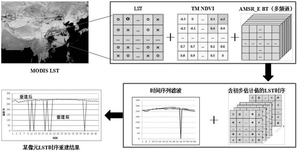
[0051] refer to Figure 1-3 , a method for estimating the pixel LST under the cloud based on microwave remote sensing and spatio-temporal information proposed by the present invention, comprising the following steps:

[0052] S1. After the Landsat / TM remote sensing dataset is preprocessed by radiometric correction, atmospheric correction, and resampling, its NDVI is calculated using the ENVI band calculation function. The formula is as follows:

[0053] NDVI=(b4-b3) / (b4+b3) 1

[0054] In the formula, b3 and b4 are the reflectivity of the third channel and the fourth channel respectively.

[0055] According to the NDVI value, the present invention divides the land cover into 6 categories, namely: NDVI<0; 0≤NDVI<0.1; 0.1≤NDVI<0.3; 0.3≤NDVI<0.5; 0.5≤NDVI<0.7;

[0056] S2, pixel segmentation: research shows that 37GHz is less affected by water vapor, cloud, rain, etc. It is...


PUM


Abstract

The invention discloses an under-the-cloud pixel LST estimation method based on microwave remote sensing and space-time information. The under-the-cloud pixel LST estimation method is characterized in that by considering land surface temperature space distribution consistency and periodicity of a time sequence, a statistical model and time sequence filtering are effectively combined together. A multi-channel statistical model based on passive microwave remote sensing is used for initial estimation of an under-the-cloud pixel LST value, and during an initial estimation process, an NDVI is used as classification basis for land surface coverage classification, and in addition, a conventional land surface type remote sensing product is abandoned to improve classification precision. An estimation value based on the statistical model is used as a background value to be filled in an LST time sequence, and by considering the influences of the former period and the latter period on a period without LST, a moving weighted filter is used to modify the estimation value to acquire an under-the-cloud pixel LST reconstruction result.

Description

technical field [0001] The invention relates to the technical field of MODIS under-cloud pixel LST estimation method, in particular to an under-cloud pixel LST estimation method based on microwave remote sensing and spatio-temporal information. Background technique [0002] Land Surface Temperature (LST) is a key parameter to measure the balance of water and heat on the earth's surface, and it is of great significance for related research in climate, hydrology, geophysics and other scientific fields. Since the 1970s, domestic and foreign scholars have carried out a lot of research on how to use thermal infrared remote sensing to obtain land surface temperature, and proposed a variety of inversion algorithms including the split window algorithm. Although thermal infrared remote sensing has a wide coverage, strong real-time performance, and can quickly obtain surface emissivity and temperature information, it is easily affected by atmospheric water vapor and cannot penetrate c...

Claims


Application Information

Patent Timeline
IPC IPC(8): G06K9/00G06T7/40
CPCG06T2207/30181G06T2207/30188G06T2207/30192G06V20/13G06V20/188
Inventor 宋冬梅臧琳单新建崔建勇
Owner CHINA UNIV OF PETROLEUM (EAST CHINA)
Why Eureka
Try Eureka