Marine density map drawing method based on GIS symbol rendering and graphical element composition

A density map and symbol technology, which is applied in the field of marine density map drawing based on GIS symbol rendering and primitive combination, can solve the problems such as the inability to realize multi-parameter complex graphics drawing, the lack of complex symbol drawing in traditional GIS systems, and the incompatibility with each other.

Inactive Publication Date: 2016-12-07
NAT MARINE DATA & INFORMATION SERVICE
View PDF6 Cites 8 Cited by
  • Summary
  • Abstract
  • Description
  • Claims
  • Application Information

AI Technical Summary

Problems solved by technology

[0003] Traditional ocean density maps are not aimed at GIS-oriented mapping, and are mostly drawn manually based on Matlab and CorelDraw software, which are used for report illustrations and illustrations, which cannot achieve the effect of map publication
Moreover, due to the incompatibility between these softwares, the attribute information in the process of mapping and drawing cannot be completely preserved, resulting in the problems of inconsistent formats of existing ocean density map results and incomplete mapping data; in addition, the traditional GIS system lacks the drawing of complex symbols , it is impossible to realize the drawing function of multi-parameter complex graphics

Method used


Image

  • Marine density map drawing method based on GIS symbol rendering and graphical element composition
  • Marine density map drawing method based on GIS symbol rendering and graphical element composition

Examples


example

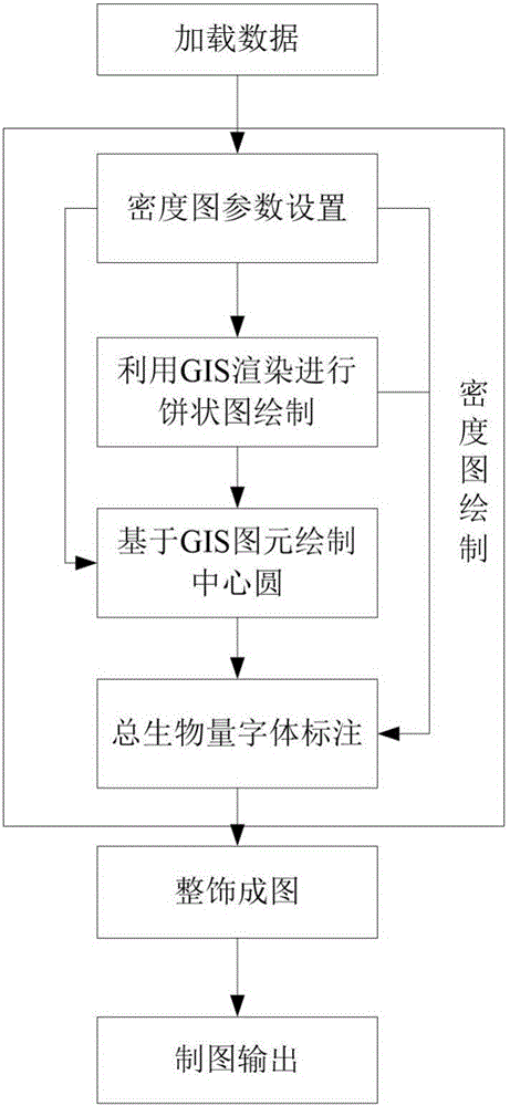
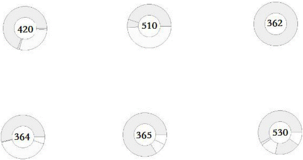
[0031] In order to clearly describe the content of the present invention, choose the making of each station intertidal zone biological total biomass density map of a survey main section to describe the execution steps in detail, as attached figure 1 as shown,

[0032] (1) Load data

[0033] Load the edited "Intertidal organisms.shp" data, the data attributes include molluscs, polychaetes, crustaceans, echinoderms, other animals, and total biomass.

[0034] (2) Density map drawing

[0035] ①Density map drawing parameter setting: According to the "my country Coastal Ocean Comprehensive Survey Element Classification Code and Legend Graphic Standard", the total biomass code of the intertidal zone at each station of the survey main section is "1203010000", in the CODE field of the database Find its matching code, ColorRampFromClr stores the color information of each type of organism, according to mollusk Y40, algae C30 / Y40, polychaetes M20 / Y30, crustaceans C20 / M40, echinoderms C25...


PUM


Abstract

The invention relates to a marine density map drawing method based on GIS symbol rendering and graphical element composition. The method includes the following steps that firstly, data including biological data used for drawing marine density maps is loaded; secondly, according to the density value of biomass in an attribute table, the marine organism density maps are drawn one by one with an investigation station as the circle center by means of a drawing mechanism of GIS symbol rendering and graphical element composition on a GIS platform; thirdly, a corresponding standard template is loaded according to the scale and the size of paper to finish map decoration; fourthly, final map content is determined, a map file is saved in an MXD format, and a map drawing result is output in a PDF or picture mode. Automatic drawing of complex marine elements is achieved on the GIS platform for the first time, and the current marine density map drawing situations that existing marine density map platforms are different, not uniform in standard and not associated with geographic positions are changed.

Description

technical field [0001] The invention belongs to the technical field of marine information, in particular to a method for drawing a marine density map based on GIS symbol rendering and graphic element combination. Background technique [0002] The ocean density map is a map that describes the species composition and quantity distribution of zooplankton, or uses a section as a statistical unit to describe the species and quantity of organisms in the intertidal zone. [0003] Traditional ocean density maps are not aimed at GIS-oriented mapping. They are mostly drawn manually based on Matlab and CorelDraw software, and are used for report illustrations, which cannot achieve the effect of map publication. And because these softwares are not compatible with each other, the attribute information in the process of mapping cannot be completely preserved, resulting in the problems of inconsistent formats of existing ocean density map results and incomplete mapping data; in addition, t...

Claims


Application Information

Patent Timeline
IPC IPC(8): G06T11/20
CPCG06T11/206
Inventor 邢喆樊妙孙毅章任群李艳雯王力彦侯辰张苗苗焦红波杨晓彤
Owner NAT MARINE DATA & INFORMATION SERVICE
Why Eureka
Try Eureka