Unmanned aerial vehicle autonomous navigation system and navigation method

An autonomous navigation system and UAV technology, applied in the field of UAV autonomous navigation system, can solve the problems that UAVs cannot realize autonomous flight, cannot judge the route and flight path by themselves, and rely on GPS satellite signals, etc.

Active Publication Date: 2016-12-21
BEIJING INSTITUTE OF TECHNOLOGYGY
View PDF6 Cites 15 Cited by
  • Summary
  • Abstract
  • Description
  • Claims
  • Application Information

AI Technical Summary

Problems solved by technology

However, due to the limitations of the UAV platform, it is impossible to judge the route and flight path by itself, so there are few technologies that can truly realize autonomous navigation flight
[0003] At present, the solution to drone navigation is GPS navigation, which relies heavily on GPS satellite signals. When the signal is unstable or lost, the drone cannot fly autonomously.

Method used


Image

  • Unmanned aerial vehicle autonomous navigation system and navigation method
  • Unmanned aerial vehicle autonomous navigation system and navigation method
  • Unmanned aerial vehicle autonomous navigation system and navigation method

Examples


Embodiment approach

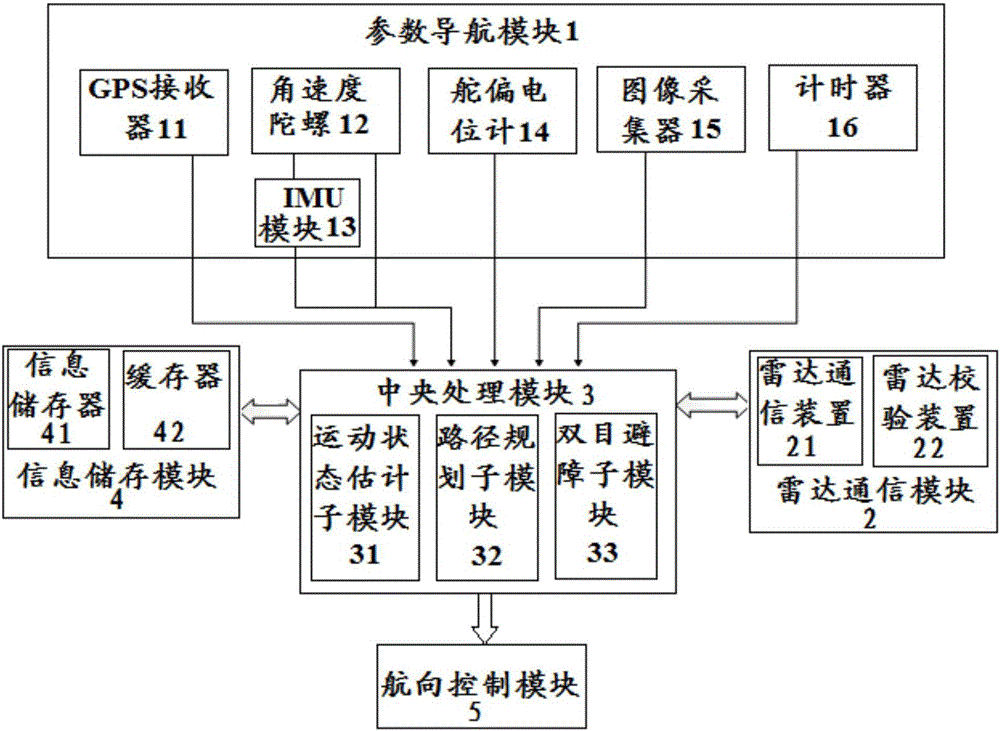
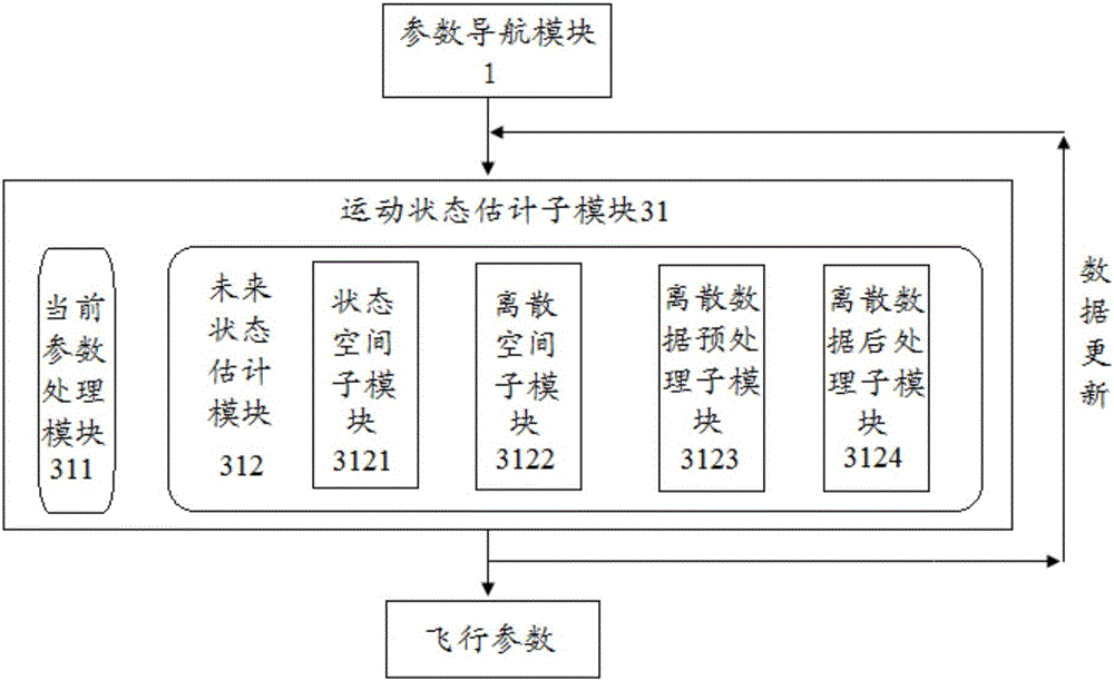
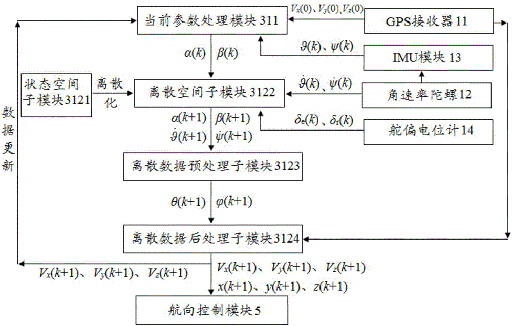
[0079] According to a preferred embodiment of the present invention, the discretization space sub-module 3122 is used to discretize the state space in the pitch direction and the state space in the yaw direction in the state space sub-module 3121 to obtain discrete spaces.

[0080] Among them, when discretizing, the Taylor formula is used to expand, and the first two items are taken to achieve linearization.

[0081] In a further preferred embodiment, the state space in the pitch direction and the state space in the yaw direction are discretized by the discretization space sub-module 3122 to obtain discrete spaces in the pitch direction as shown in formula (3-1) and formula (3-2) and yaw direction discrete spaces:

[0082]

[0083] Among them, in formula (3-1), T is the sampling period, k represents the current moment, k+1 represents the next moment; α(k+1) is the angle of attack at the next moment, and α(k) is the current moment The angle of attack, α(k) is obtained from ...


PUM


Abstract

The invention discloses an unmanned aerial vehicle autonomous navigation system and a navigation method. The system comprises a parameter navigation module, a radar navigation module, a central processing module, an information storage module and a heading control module, wherein the parameter navigation module comprises a GPS receiver, an angular rate gyroscope, an IMU module, a rudder deflection potentiometer, an image acquisition unit and a timer. The navigation method comprises the following steps: when GPS signals are instable or are lost transiently, state parameters outputted by the parameter navigation module are processed in the central processing module to obtain flight parameters; when the GPS signals are lost for a long time and the parameter navigation module can not be used for navigation, the radar navigation module is used for navigation; and when the GPS signals are lost for a long time, the parameter navigation module fails and radar signals can not be received, the central processing module is used for path planning. The system and the method provided by the invention can provide accurate navigation for the unmanned aerial vehicle in a condition without GPS signals.

Description

technical field [0001] The present invention relates to an autonomous navigation system of an unmanned aerial vehicle, in particular to an autonomous navigation system for an unmanned aerial vehicle dealing with the situation of no GPS signal. Background technique [0002] UAVs have the advantages of small size and low cost, and with the rapid development of flight control technology, communication technology and electronic technology, the performance of UAVs has been continuously enhanced, and the types have continued to increase, making it widely used in military and civilian fields. The demand is increasing and the utilization rate is increasing day by day. However, due to the limitations of the UAV platform, it is impossible to judge the route and flight path by itself, so there are few technologies that can truly realize autonomous navigation and flight. [0003] At present, the solution to drone navigation is GPS navigation, which relies heavily on GPS satellite signa...

Claims


Application Information

Patent Timeline
Patent Type & Authority Applications(China)
IPC IPC(8): G05D1/10
CPCG05D1/101
Inventor 林时尧王伟林德福王江裴培王广山
Owner BEIJING INSTITUTE OF TECHNOLOGYGY
Why Eureka
Try Eureka