Water source type analysis method based on physical geographic features

A technology of water source type and natural geography, applied in the direction of spectrometry/spectrophotometry/monochromator, optical radiation measurement, instrument, etc., can solve the comprehensive impact of water cycle with less work, more water source analysis work, and less research work And other issues

Inactive Publication Date: 2017-01-04
CHINA INST OF WATER RESOURCES & HYDROPOWER RES +1
View PDF2 Cites 17 Cited by
  • Summary
  • Abstract
  • Description
  • Claims
  • Application Information

AI Technical Summary

Problems solved by technology

[0003] At present, for water source analysis, a lot of work has been done on the analysis of water source type and composition from the perspective of "water budget and balance" at home and abroad, using tracer, simulation and other technical means; however, the water source type and composition show "three The basic characteristic defects of "more, three less": first, "more rivers and less slope", that is, there are many analyzes of water sources for different rivers or lake sections, and relatively few studies on the composition of water sources on different slope units; second, "more states and processes less”, that is, there are many studies on a certain period of time or at a certain time node, and there are relatively few works on the evolution process of various element types of water sources and their comprehensive impact on the water cycle; the third is “more decomposition and less inspection”, that is, for a single method There is a lot of analysis work on the composition of water sources, and there is relatively little research work to verify the scientificity and reliability of the analysis results using various methods; in addition, in high-altitude areas such as the Qinghai-Tibet Plateau, affected by data and scientific research conditions, Relevant research work is still less

Method used


Image

  • Water source type analysis method based on physical geographic features
  • Water source type analysis method based on physical geographic features
  • Water source type analysis method based on physical geographic features

Examples


Embodiment Construction

[0026] The following will clearly and completely describe the technical solutions in the embodiments of the present invention with reference to the drawings in the embodiments of the present invention. Obviously, the described embodiment is only one embodiment of the present invention, not all embodiments. Based on the embodiments of the present invention, all other embodiments obtained by persons of ordinary skill in the art without making creative efforts belong to the protection scope of the present invention.

[0027] For the sake of simplicity, common technical knowledge known to those skilled in the art is omitted in the following content.

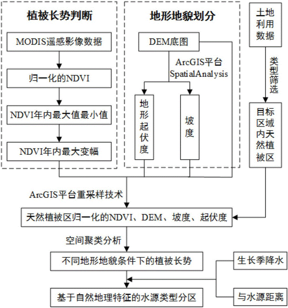
[0028] Such as figure 1 As shown, the water source type analysis method based on natural geographical features, which includes:

[0029] S1: Collect remote sensing image data in the target area, process the remote sensing image data, and obtain the maximum and minimum values ​​of the vegetation coverage index in the year; Data coll...


PUM


Abstract

The invention discloses a water source type analysis method based on physical geographic features, and the method comprises the steps: collecting remote-sensing image data in a target region, carrying out the processing of the remote-sensing image data, and obtaining the maximum and minimum values of a yearly vegetation cover index; calculating the difference between the maximum and minimum values of the yearly vegetation cover index, and obtaining the maximum change amplitude of the yearly vegetation cover index; obtaining a terrain factor, related with the landform classification, in the target region; obtaining a natural vegetation zone in the target region; carrying out the normalization processing of the maximum change amplitude of the yearly vegetation cover index of the natural vegetation region and the landform factor of the natural vegetation region, and obtaining the landform subregions in the natural vegetation region and the vegetation growth conditions of different subregions through employing the technologies of ArcGIS spatial clustering analysis and spatial analysis; obtaining the vegetation growth rainfall in the landform subregions and the distances with water sources; analyzing the supply types of water sources in the subregions according to the vegetation growth rainfall in the landform subregions and the distances with a water sources, and obtaining the water source type subregions based on the physical geographic features.

Description

technical field [0001] The invention specifically relates to a water source type analysis method based on natural geographical features. Background technique [0002] The characteristics of water sources in different geographic units are affected by regional precipitation characteristics (phase state and composition, rainfall pattern, rainfall intensity, and temporal and spatial distribution), underlying surface conditions (vegetation, soil, and aquifer complexes), energy processes, spatial hydraulic connections, and human factors. The comprehensive impact of water and land resources development activities, etc.; under the influence of climate change and human activities, the composition and evolution mechanism of water sources in different geographical units are very different, and have significant multi-scale spatio-temporal characteristics; scientific water source analysis is not only to identify inconsistent runoff It is also the key basis for targeted and precise multi-...

Claims


Application Information

Patent Timeline
Patent Type & Authority Applications(China)
IPC IPC(8): G06K9/00G06K9/62G06V20/13G06V10/26
CPCG06V20/13G06F18/23G06V10/26G06F18/2431G01J3/2823G01J2003/283
Inventor 严登华宫博亚史婉丽翁白莎秦天玲杨朝晖
Owner CHINA INST OF WATER RESOURCES & HYDROPOWER RES
Why Eureka
Try Eureka