Radar target location analysis method based on graphic geographic information

A target location and geographic information technology, applied in the field of target location analysis, can solve the problems of high regional complexity, large amount of calculation for location point judgment, and many polygon vertices, etc., to simplify the judgment process, reduce the amount of calculation, and reduce the complexity of calculation Effect

Active Publication Date: 2017-01-18
NANJING LES ELECTRONICS EQUIP CO LTD
View PDF6 Cites 5 Cited by
  • Summary
  • Abstract
  • Description
  • Claims
  • Application Information

AI Technical Summary

Problems solved by technology

For radar targets, there are many targets and fast data update. In actual use, there may be multiple polygonal areas, and the area complexity is high, that is, there are many polygonal vertices. Therefore, the corresponding position points that need to be processed are judged and calculated. The amount is large, and there is a problem of computational efficiency in application

Method used


Image

  • Radar target location analysis method based on graphic geographic information
  • Radar target location analysis method based on graphic geographic information
  • Radar target location analysis method based on graphic geographic information

Examples


Embodiment

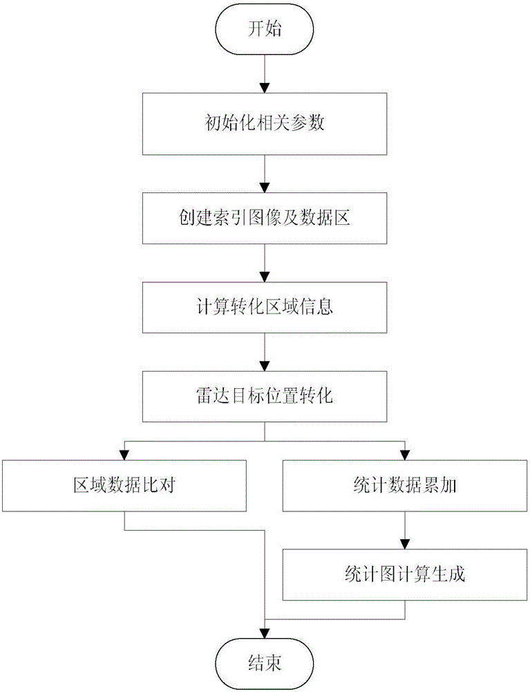
[0048] Taking the commonly used warning radar as an example, the technical solution of the present invention is described in detail, but the protection scope of the present invention is not limited to the embodiments.

[0049] Suppose the specific content is as follows:

[0050]

[0051] (1) Setting parameter values, the radar power range R=200km, the side length W=2000 of the index image I, and the number of area types N=2.

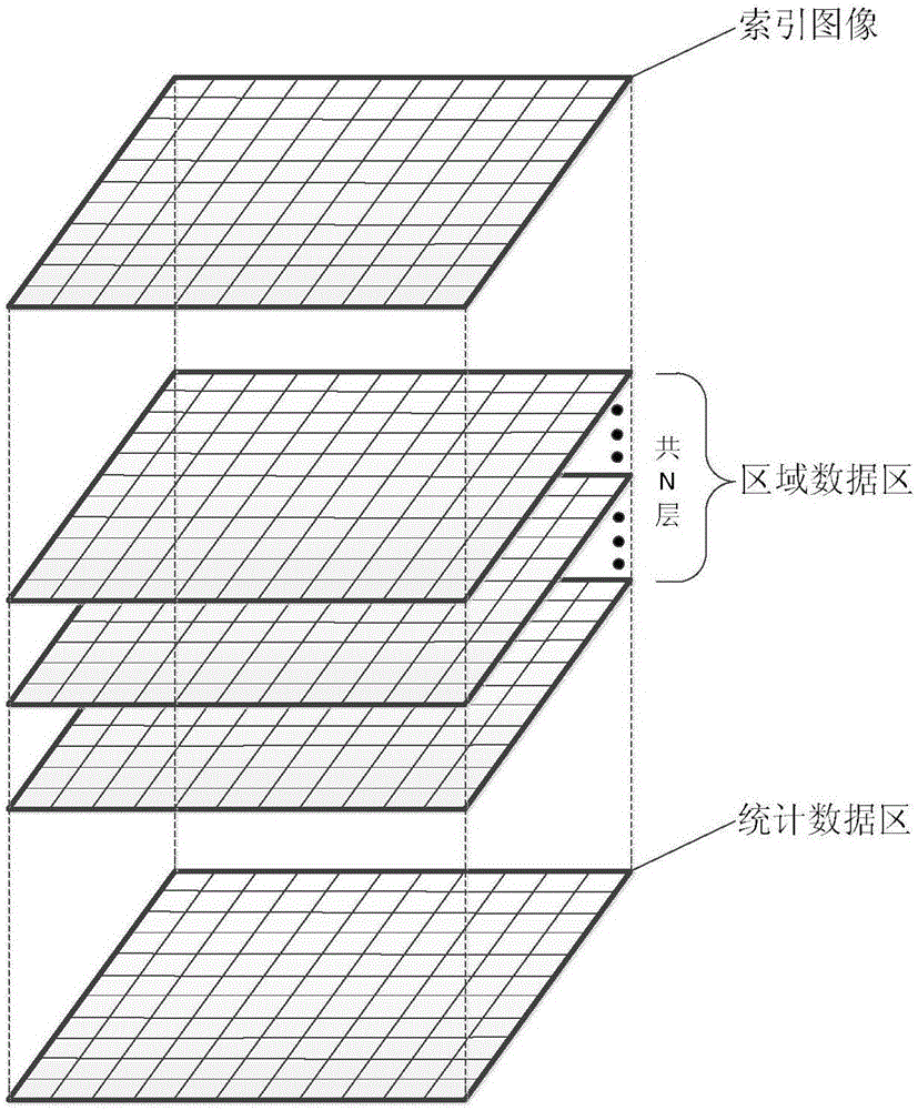
[0052] (2) create an index image I, the size is 2000 * 2000, the distance represented by each pixel is 2R / W=2 * 200 / 2000=0.2km; create a data area, the data size of the area data area D is selected as N A =1, that is, one byte is used, the size of the data area of ​​the entire area is 2000×2000×1, and the statistical data area D T The data size is selected as N T =1, the size of the entire statistical data area is 2000×2000×1, initialize the data area and set all to 0.

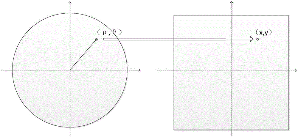
[0053] (3) According to the setting parameters, the position conversion formul...


PUM


Abstract

The invention discloses a radar target location analysis method based on graphic geographic information. According to the method, the geographic information of the might range is mapped to image data based on a certain corresponding relationship according to the radar target location characteristics, and a corresponding local data area and a statistical data area are created with the image pixel locations acting as indexes; local information is edited on the image according to the actual demand, and the local area are updated in the local data area; the target geographic coordinate information is mapped to the image data in application, the data of the local data area corresponding to the image location are acquired, and the location relationship between the target and the related area is judged according to the data value; meanwhile, counting updating of the statistical data area can also be performed, and a statistical graph is formed through normalization. The geographic location information under a radar polar coordinate system is converted to plane image information so that the algorithm is simple and rapid, judgment of the target location can be efficiently completed in real time, and local monitoring, alarm and statistical functions can be realized.

Description

technical field [0001] The invention belongs to the technical field of target position analysis, in particular to a radar target position analysis method based on graphical geographical information. Background technique [0002] It is a basic algorithm of computer graphics to determine the inclusion relationship between points on the plane and simple polygons, and it is widely used in computer graphics processing, pattern recognition, CAD and scientific computing visualization. In the radar duty system, the identification of the positional relationship between the target and the given area also has a wide range of application requirements. The positional relationship of the no-fly zone, etc. [0003] There have been many classic algorithms for the judgment of the inner and outer points of polygons, such as ray method, cross product discriminant method and angle sum discriminant method, among which the ray method is the most widely used: draw a ray from the detection point t...

Claims


Application Information

Patent Timeline
Patent Type & Authority Applications(China)
IPC IPC(8): G06T11/00G06F17/30
CPCG06F16/29G06T11/001
Inventor 孙海军常传文嵇亮亮叶玲王远斌周源王如亲冯伟伟姜立马志强习云飞王冰山
Owner NANJING LES ELECTRONICS EQUIP CO LTD
Why Eureka
Try Eureka