Automatic track generating method for unmanned aerial vehicle

A drone and track technology, applied in the field of drones, can solve the problems of material leakage, difficult to guarantee operation accuracy, and battery waste.

Active Publication Date: 2017-02-15
湖南植保无人机技术有限公司
View PDF8 Cites 44 Cited by
  • Summary
  • Abstract
  • Description
  • Claims
  • Application Information

AI Technical Summary

Problems solved by technology

[0002] At present, most of the spraying operations of drones are manual operations, and the accuracy of the operations is difficult to guarantee. Due to the lack of remote detection of spraying boredom and remote detection of battery remaining, pilots often use estimation methods to estimate materials in the process of operation. and battery remaining, this operation method is likely to cause waste of batteries and leakage of materials
[0003] At present, there are some agricultural drones with autonomous navigation function. The route planning method is to mark the boundary of the field on the satellite map and carry out equidistant route planning. Considering the accuracy of manual marking and the low time domain resolution of satellite remote sensing images rate and the difference between the projection reference ellipsoid between the GPS receiver and the domestic map, this method cannot accurately obtain the field boundary; at the same time, this method cannot accurately obtain the obstacles in the field and the coordinates of the home point. Common UAVs use the take-off point as the home point, and when the UAV encounters abnormal conditions, such as low battery power and insufficient medicine box remaining, it will automatically return
However, due to the complex airspace environment in rural areas, there are often obstacles such as utility poles, high-voltage lines, and fences. In the absence of a reliable and reliable autonomous obstacle avoidance mechanism, it is impossible to ensure that the UAV can return safely.

Method used


Image

  • Automatic track generating method for unmanned aerial vehicle
  • Automatic track generating method for unmanned aerial vehicle
  • Automatic track generating method for unmanned aerial vehicle

Examples


Embodiment Construction

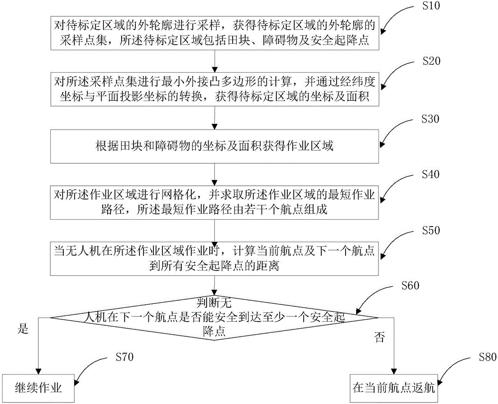
[0048] Combine below Figure 1-Figure 3 The technical solutions of the present invention are further described through specific implementation methods.

[0049] figure 1 It is a flow chart of a UAV automatic track generation method provided in this embodiment.

[0050] A method for generating an automatic track of an unmanned aerial vehicle, comprising:

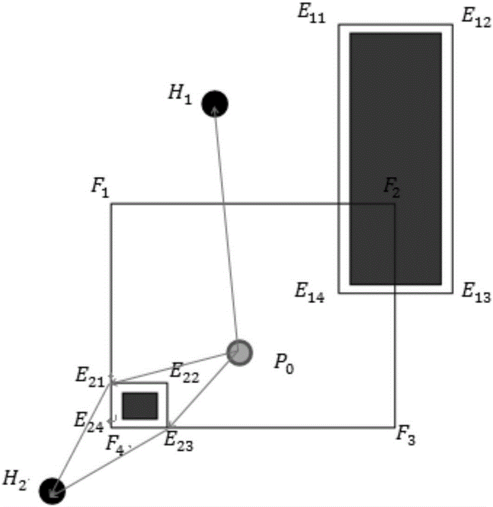
[0051] S10. Sampling the outer contour of the area to be calibrated to obtain a sampling point set of the outer contour of the area to be calibrated, the area to be calibrated includes fields, obstacles, and safe take-off and landing points;

[0052] S20. Calculating the smallest circumscribed convex polygon on the sampling point set, and obtaining the coordinates and area of ​​the area to be calibrated by converting the latitude and longitude coordinates and the plane projection coordinates;

[0053] S30. Obtain the operation area according to the coordinates and areas of the fields and obstacles;

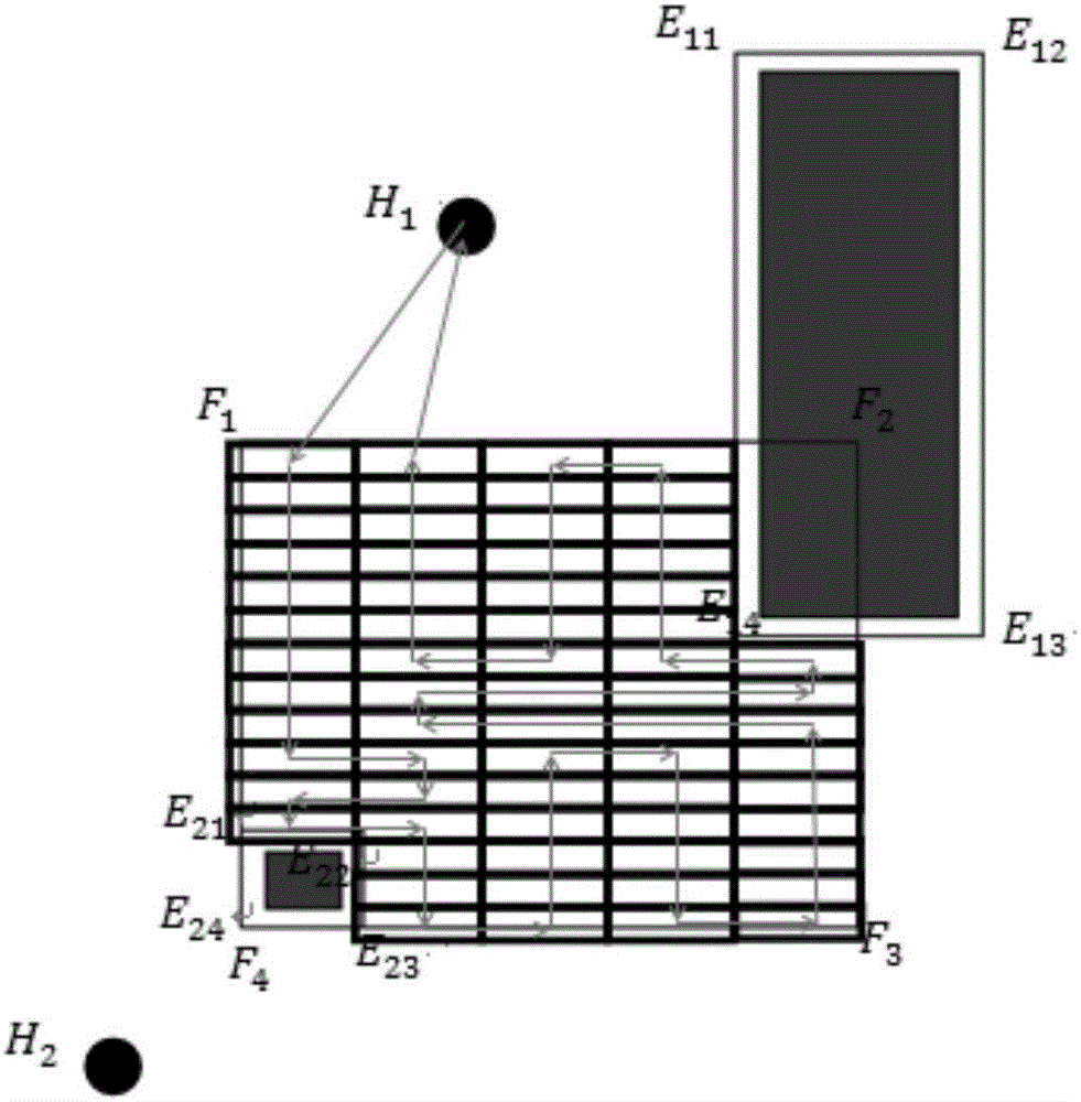
[0054] S40. Perform gri...


PUM


Abstract

The invention relates to the technical field of unmanned aerial vehicles, in particular to an automatic track generating method for an unmanned aerial vehicle. The automatic track generating method comprises the following steps: sampling the outer contour of a to-be-calibrated area; carrying out calculation of minimal external convex polygon on a sampling point set, and conversing latitude and longitude coordinates and plane projection coordinates to obtain coordinates and the area of the to-be-calibrated area; obtaining an operation area according to the coordinates and the areas of a field block and an obstacle, and calculating a shortest operation path of the operation area; when the unmanned aerial vehicle operates in the operation area, judging whether the unmanned aerial vehicle safely reaches a next safe take-off and landing point or not at a next waypoint; and if the unmanned aerial vehicle safely reaches the next safe take-off and landing point at the next waypoint, continuously operating, otherwise, returning at the existing waypoint. According to the automatic track generating method, the coordinates and the areas of the filed block, the obstacle and the safe take-off and landing point can be precisely calibrated, and the shortest operation path can be automatically generated, so that the unmanned aerial vehicle can automatically avoid the obstacle while automatically operating according to the shortest operation path, and can automatically select the nearest safe take-off and landing point to carry out automatic return.

Description

technical field [0001] The invention relates to the technical field of unmanned aerial vehicles, in particular to a method for generating automatic flight paths of unmanned aerial vehicles. Background technique [0002] At present, most of the spraying operations of drones are manual operations, and the accuracy of the operations is difficult to guarantee. Due to the lack of remote detection of spraying boredom and remote detection of battery remaining, pilots often use estimation methods to estimate materials in the process of operation. And the remaining amount of the battery, this kind of operation method is easy to cause the waste of the battery and the leakage of the material. [0003] At present, there are some agricultural drones with autonomous navigation function. The route planning method is to mark the boundary of the field on the satellite map and carry out equidistant route planning. Considering the accuracy of manual marking and the low time domain resolution o...

Claims


Application Information

Patent Timeline
Patent Type & Authority Applications(China)
IPC IPC(8): G01C21/20
CPCG01C21/20
Inventor 何明昊付维
Owner 湖南植保无人机技术有限公司
Why Eureka
Try Eureka