Scarce control point space-borne synthetic aperture radar image ground positioning method

A technology of synthetic aperture radar and positioning method, which is applied in the direction of radio wave reflection/re-radiation, utilization of re-radiation, and measurement devices, and can solve the problems of few researches on ground positioning

Inactive Publication Date: 2017-02-22
INST OF ELECTRONICS CHINESE ACAD OF SCI
View PDF3 Cites 10 Cited by
  • Summary
  • Abstract
  • Description
  • Claims
  • Application Information

AI Technical Summary

Problems solved by technology

[0007] It can be seen that the ground positioning of remote sensing images of existing rare control points is mainly based on optical images, while the research on ground positioning under the condition of sparse control of SAR images is very little. The number of SAR images to locate the ground is a problem that needs to be solved

Method used


Image

  • Scarce control point space-borne synthetic aperture radar image ground positioning method
  • Scarce control point space-borne synthetic aperture radar image ground positioning method
  • Scarce control point space-borne synthetic aperture radar image ground positioning method

Examples


Embodiment Construction

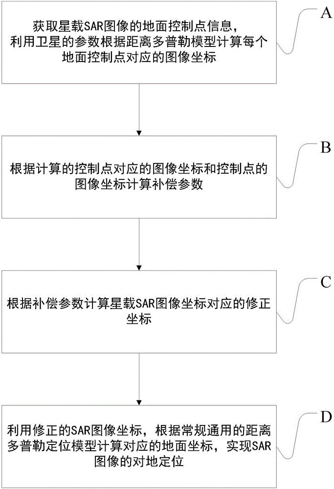
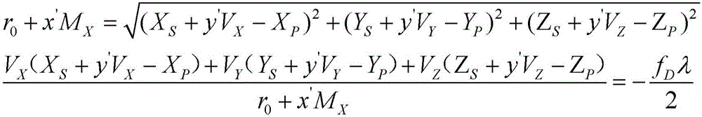
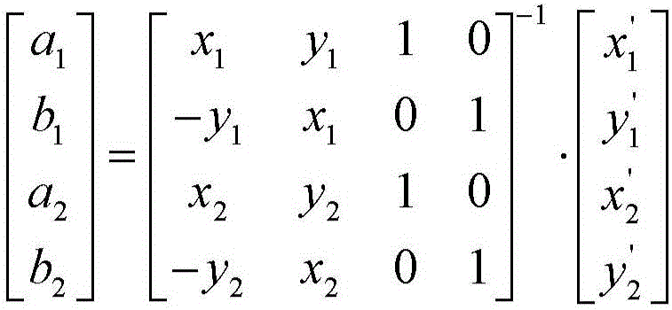
[0021] In order to make the object, technical solution and advantages of the present invention clearer, the present invention will be further described in detail below in conjunction with specific embodiments and with reference to the accompanying drawings.

[0022] In order to make the object, technical solution and advantages of the present invention clearer, the present invention will be described in further detail below in conjunction with specific embodiments and with reference to the accompanying drawings. It should be noted that, in the drawings or descriptions of the specification, similar or identical parts all use the same figure numbers. Implementations not shown or described in the accompanying drawings are forms known to those of ordinary skill in the art. Additionally, while illustrations of parameters including particular values ​​may be provided herein, it should be understood that the parameters need not be exactly equal to the corresponding values, but rather...


PUM


Abstract

The invention discloses a scarce control point space-borne synthetic aperture radar image ground positioning method, comprising: step A, acquiring ground control point information of a space-borne synthetic aperture radar image, and calculating corresponding image coordinates of each ground control point by using satellite parameters according to a distance-Doppler model; step B, calculating a compensation parameter according to the calculated corresponding image coordinates of the control points and the practical image coordinates of the control points; step C, calculating corresponding corrected coordinates of the space-borne synthetic aperture radar image coordinates according to the compensation parameter; and step D, calculating corresponding ground coordinates by using the corrected coordinates according to the distance-Doppler model, thus realizing ground positioning of the space-borne synthetic aperture radar image. The method can calculate the compensation parameter of the image coordinates according to the specific quantity of scarce control points by adopting different models, and can well adapt to the quantity change of the control points.

Description

technical field [0001] The invention relates to the technical field of spaceborne synthetic aperture radar remote sensing image processing, in particular to a ground positioning method for SAR images of rare control points. Background technique [0002] Spaceborne Synthetic Aperture Radar (SAR for short in English, hereinafter referred to as SAR) remote sensing is to obtain high-resolution images of the ground based on the synthetic aperture technology of the radar mounted on the satellite. , so it can play an irreplaceable role in national economic construction and national defense security. At present, spaceborne SAR remote sensing technology is being vigorously developed both at home and abroad. [0003] The ground positioning of spaceborne SAR images is the basis of image application and analysis. At present, the main positioning strategies are: (1) system-level ground positioning without any ground control points; (2) advanced ground positioning with ground control poin...

Claims


Application Information

Patent Timeline
Patent Type & Authority Applications(China)
IPC IPC(8): G01S13/90
CPCG01S13/90G01S13/9027
Inventor 尤红建
Owner INST OF ELECTRONICS CHINESE ACAD OF SCI
Why Eureka
Try Eureka