
An Object-Oriented Automatic Extraction Method of Cultivated Land Information Based on Triangulation

An object-oriented, automatic extraction technology, applied in image analysis, image enhancement, instruments, etc., can solve problems such as poor extraction effect, and achieve the effect of improving extraction efficiency, high precision, and high stability

Active Publication Date: 2019-07-26
NANJING UNIV
View PDF6 Cites 0 Cited by
  • Summary
  • Abstract
  • Description
  • Claims
  • Application Information

AI Technical Summary

Problems solved by technology

However, it only uses a single shape feature, and the extraction effect on complex environments is not good.

Method used


Image

  • An Object-Oriented Automatic Extraction Method of Cultivated Land Information Based on Triangulation
  • An Object-Oriented Automatic Extraction Method of Cultivated Land Information Based on Triangulation
  • An Object-Oriented Automatic Extraction Method of Cultivated Land Information Based on Triangulation

Examples


Embodiment Construction

[0049] The purpose and effects of the present invention will become more apparent by referring to the accompanying drawings in detail of the present invention.

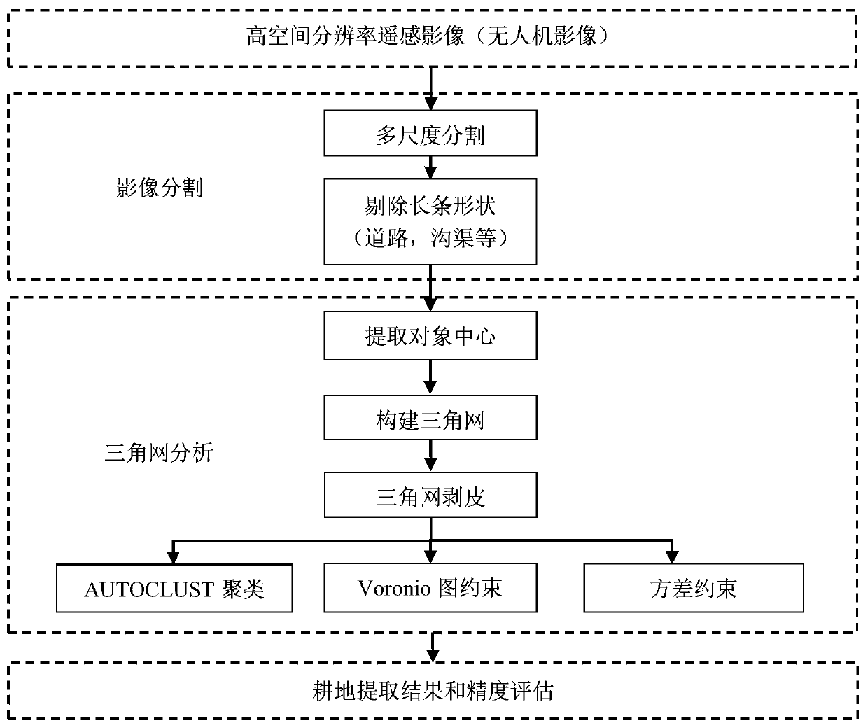
[0050] Such as figure 1 Shown is the flow chart of the object-oriented cultivated land information automatic extraction method based on triangulation in the embodiment of the present invention, this implementation method comprises the following steps:

[0051] Step 1. Segment the high spatial resolution image by using the multi-scale segmentation method. In this embodiment, eCognition is used to repeatedly segment images with high spatial resolution, and the distribution characteristics of the segmented objects are observed, and a segmentation scale that is better for segmenting cultivated land blocks is selected for image segmentation. The present invention suggests that the value range of the segmentation scale is [150,200], so as to highlight the difference between the segmentation objects corresponding to the res...


PUM


Abstract

The invention relates to an object-oriented automatic extraction method of cultivated land information based on triangulation, the steps of which are: using multi-scale segmentation method to segment high spatial resolution images; eliminating strip-shaped segmentation objects (roads, ditches, etc.); Segment the center point of the object; use the center point to construct a triangular network; perform peeling operations on the triangular network; use the AUTOCLUST clustering algorithm to construct a triangular network and cluster; use V-graph constraints to optimize the clustering results and avoid over-clustering and under-clustering category; use the maximum variance constraint to eliminate the remaining sporadic forest land; obtain the cultivated land extraction results and evaluate the accuracy. The invention overcomes the problem of large amount of high-spatial-resolution remote sensing image data and difficult processing, makes full use of the semantic information provided by the segmented objects, and eliminates objects that interfere with the extraction of cultivated land information such as residential areas and roads, thereby efficiently performing Automatic extraction of cultivated land information, and ensure the integrity of cultivated land extraction.

Description

technical field [0001] The invention relates to a method for automatically extracting cultivated land information, in particular to an object-oriented, efficient and non-supervised method for extracting cultivated land information. Background technique [0002] The automatic extraction of cultivated land information plays a vital role in the management of rural land resources and land planning in my country. At present, the relevant technical methods of cultivated land information mapping are mainly based on remote sensing technology. There have been many studies on cropland information extraction at different spatial scales, mainly divided into local, regional, and global regions. Local-scale studies mainly involve single regions or irrigation basins or specific regions; regional-scale studies mainly include large river basins and continental regions; and global-scale studies mainly involve the mapping of cultivated land information on a global scale. At different spatial...

Claims


Application Information

Patent Timeline
Patent Type & Authority Patents(China)
IPC IPC(8): G06K9/00G06K9/34G06K9/62G06T7/12G06T7/62G06T7/66
CPCG06T2207/30188G06T2207/10032G06T2207/20021G06T2207/20016G06V20/13G06V10/267G06F18/23
Inventor 马磊高宇李满春陈探傅腾宇周桢津张戈汤皓卿陈振杰
Owner NANJING UNIV
Learn More