

Correction method of extinction coefficient below low clouds in laser radar retrieval
A technology of laser radar and extinction coefficient, applied in the field of laser radar and environmental science, it can solve the problem of small extinction coefficient under the clouds, and achieve the effect of correcting deviation
- Summary
- Abstract
- Description
- Claims
- Application Information
AI Technical Summary
Problems solved by technology
Method used
Image

Examples
Embodiment Construction
[0023] In order to make the purpose, technical solution and advantages of the present invention clearer, a further detailed description will be given below in combination with specific data. Here, the illustrative examples of the present invention are used to explain the present invention, but not to limit the present invention.
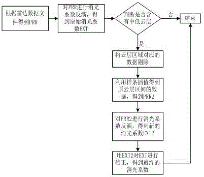
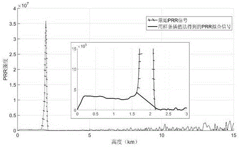
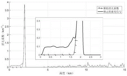
[0024] In the correction method provided by the present invention, through the spline interpolation method, the height interval of the lidar PRR (distance square correction signal) cloud layer is fitted to obtain the false signal not containing the cloud layer, and the Fernald inversion method is used to obtain the false signal not affected by the cloud layer. The extinction coefficient, and then correct the extinction coefficient below the cloud layer in the original extinction signal, the main steps are as follows:
[0025] (1) The laser radar equation corresponding to the backscattered echo signal of the meter scattering laser radar is:
[0026] ...
PUM
 Abstract
Description
Claims
Application Information