Two-step integral inverse method for determining geoidal surface based on band-limited aerial vector gravity

A technique of geoid and inverse solution, applied in the field of airborne vector gravity measurement, can solve problems that are difficult to meet engineering applications

Active Publication Date: 2017-05-10
THE CHINESE PEOPLES LIBERATION ARMY 92859 TROOPS
View PDF4 Cites 11 Cited by
  • Summary
  • Abstract
  • Description
  • Claims
  • Application Information

AI Technical Summary

Problems solved by technology

[0003] At present, the research on determining the geoid based on the aviation vector gravity is based on the principle similar to the astronomical level, and the horizontal component of the vector gravity is converted into the disturbance level on the route by line-by-survey section integration, and the disturbance level is extended downward to the geoid. Finally, use the Bruns formula to calculate the geoid fluctuations. However, the above method obtains the relative geoid, and the geoid needs to be added to the datum, which is difficult to meet the needs of engineering applications.

Method used


Image

  • Two-step integral inverse method for determining geoidal surface based on band-limited aerial vector gravity
  • Two-step integral inverse method for determining geoidal surface based on band-limited aerial vector gravity
  • Two-step integral inverse method for determining geoidal surface based on band-limited aerial vector gravity

Examples


Embodiment Construction

[0035] Embodiments of the present invention will be described in further detail below in conjunction with the accompanying drawings.

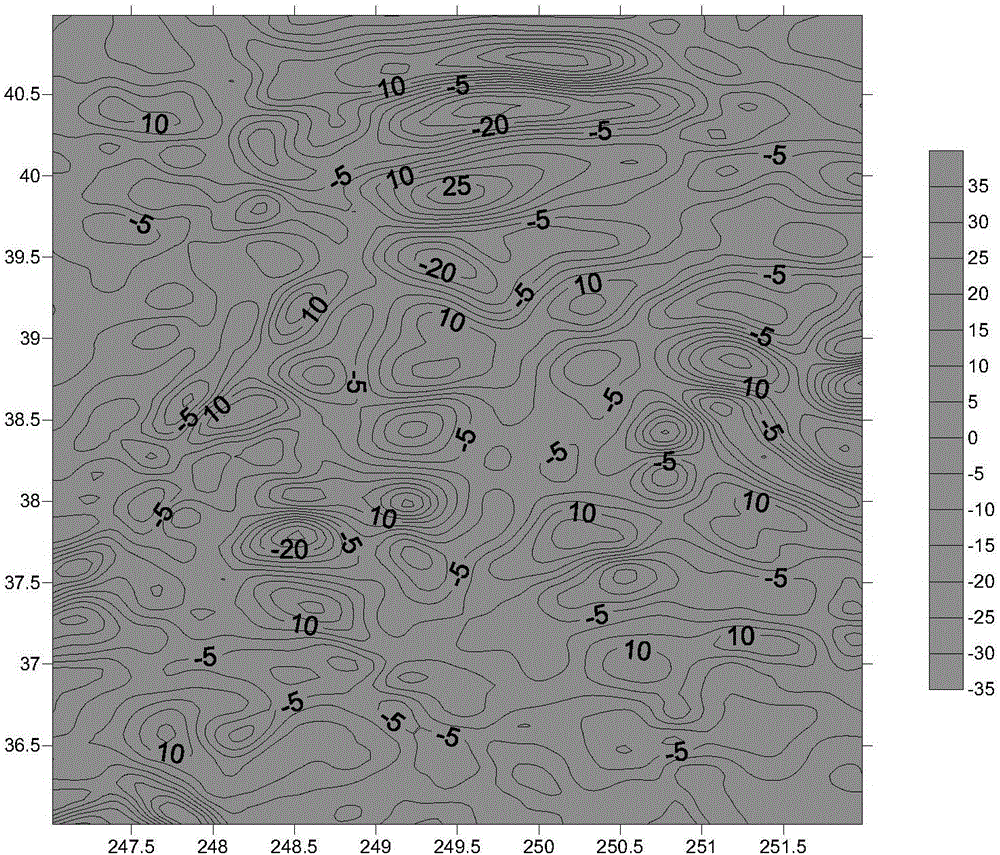
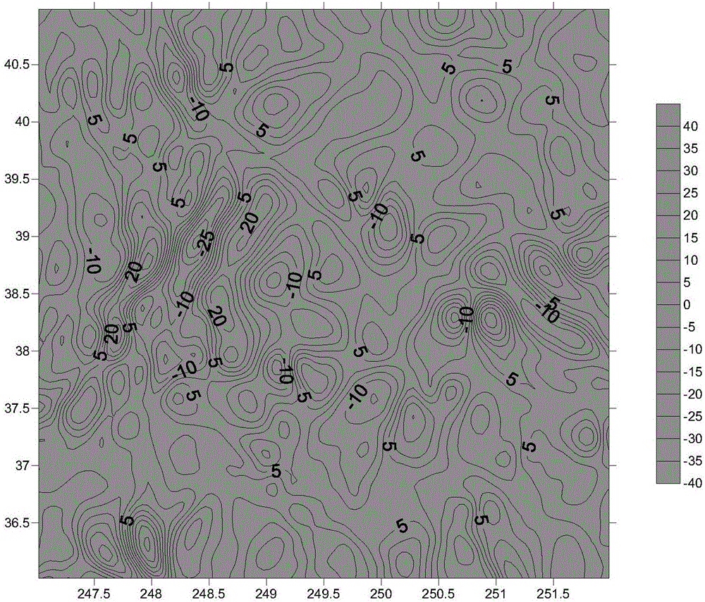
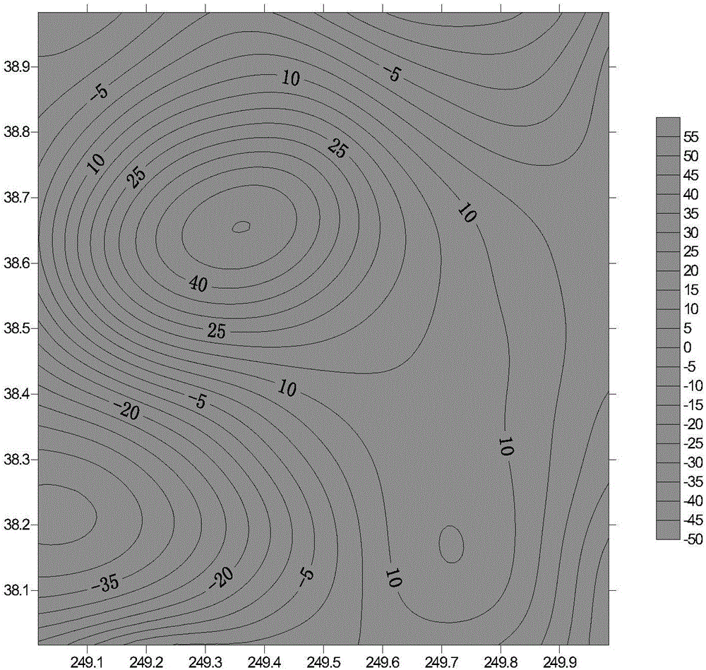
[0036] The invention is a new method for calculating the geoid based on aviation vector gravity data, which mainly includes the following contents: according to the generalized horizontal boundary value theory, the band-limited aviation disturbance position is calculated based on the band-limited aviation vector gravity; according to the inverse Poisson integral model, based on The band-limited disturbance potential is extended downward to obtain the band-limited sea surface disturbance potential, and the geoid is calculated by the Bruns formula.

[0037] In order to make the object, technical solution and advantages of the present invention clearer, the content of the present invention will be described in detail below with reference to the accompanying drawings and examples.

[0038] Use the global high-order gravity field model EGM2008 to si...


PUM


Abstract

The present invention relates to a two-step integral inverse method for determining a geoidal surface based on band-limited aerial vector gravity. The method includes the following steps that: based on a generalized horizontal boundary value theory, band-limited aerial vector gravity at the altitude of a flight line is adopted to calculate band-limited aeronautical disturbing potential; and an inverse Poisson integral model is adopted to extend downwards the band-limited aeronautical disturbing potential to a sea surface, so that band-limited sea surface disturbing potential can be obtained, and the band-limited sea surface disturbing potential is converted into the geoidal surface through using the Bruns formula. The method of the invention is reasonable in design. With the method adopted, a new solution is provided for calculating the geoidal surface based on the band-limited aerial vector gravity, a calculation function for determining the geoidal surface by using the band-limited aerial vector gravity is realized, and the accuracy of the obtained geoidal surface can satisfy engineering application requirements.

Description

technical field [0001] The invention belongs to the technical field of aerial vector gravity measurement, in particular to a two-step integral inverse solution method for determining the geoid based on band-limited aerial vector gravity. Background technique [0002] The aviation vector gravity measurement technology uses the aircraft as the carrier, the inertial navigation system and the global satellite navigation and positioning system as the sensor, and obtains the specific force information and the inertial acceleration information of the carrier respectively, and calculates the vector at the aviation altitude through coordinate conversion and filtering. gravity. The geoid is a closed surface representing the shape of the earth, defined as the earth's gravitational equipotential surface that best fits the global non-tidal static mean sea level, and is also a physical surface that can reflect the earth's internal structure and density distribution characteristics. Deter...

Claims


Application Information

Patent Timeline
Patent Type & Authority Applications(China)
IPC IPC(8): G01V7/00
CPCG01V7/00
Inventor 邓凯亮欧阳永忠陆秀平吴太旗黄辰虎李凯锋黄贤源范龙王耿峰陈欣
Owner THE CHINESE PEOPLES LIBERATION ARMY 92859 TROOPS
Why Eureka
Try Eureka