High-precision 3D GIS Earch implementing method and system
An implementation method and high-precision technology, which is applied in the field of 3D simulation and can solve the problems of small single-chip size and low precision.
- Summary
- Abstract
- Description
- Claims
- Application Information
AI Technical Summary
Problems solved by technology
Method used
Image

Examples
Embodiment Construction
[0022] It should be noted that, in the case of no conflict, the embodiments of the present invention and the features in the embodiments can be combined with each other.
[0023] The present invention will be described in detail below with reference to the accompanying drawings and examples.
[0024] The implementation method of high-precision 3D GIS Search includes the following steps:
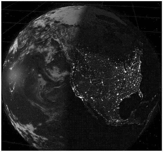
[0025] 1) Construct a polyhedron with the graphical modeling software 3ds Max, and use the normal mapping software CrazyBump to perform bump mapping on the surface of the polyhedron according to the earth's surface graphics. After fine-tuning the parameters, a satisfactory bump map is obtained, and finally the main body of the earth model is obtained ;
[0026] Finally, a large-scale high-precision earth map with a size of 16K is obtained. The source of the texture is a two-dimensional google satellite map. Among them, the small-sized texture is assembled by PhotoShop software and the border...
PUM
 Abstract
Description
Claims
Application Information
 - R&D
- Intellectual Property
- Life Sciences
- Materials
- Tech Scout
- Unparalleled Data Quality
- Higher Quality Content
- 60% Fewer Hallucinations
Browse by: Latest US Patents, China's latest patents, Technical Efficacy Thesaurus, Application Domain, Technology Topic, Popular Technical Reports.
© 2025 PatSnap. All rights reserved.Legal|Privacy policy|Modern Slavery Act Transparency Statement|Sitemap|About US| Contact US: help@patsnap.com