Low-earth-orbit satellite backup navigation system Doppler positioning calculation method

A low-orbit satellite and positioning calculation technology, applied in the field of Doppler positioning calculation, to achieve the effect of improving positioning accuracy, low calculation amount, and high use value

Active Publication Date: 2017-05-31
NO 54 INST OF CHINA ELECTRONICS SCI & TECH GRP
View PDF3 Cites 16 Cited by
  • Summary
  • Abstract
  • Description
  • Claims
  • Application Information

AI Technical Summary

Problems solved by technology

[0009] According to the above-mentioned background technology, in order to solve the continuous positioning and solving problem of the low-orbit satellite backup navigation system under the condition of adapting to the number of different visible stars, the present invention provides a Doppler algorithm combining grid search and Newton least squares iterative calculation. Lex location solution method

Method used


Image

  • Low-earth-orbit satellite backup navigation system Doppler positioning calculation method
  • Low-earth-orbit satellite backup navigation system Doppler positioning calculation method
  • Low-earth-orbit satellite backup navigation system Doppler positioning calculation method

Examples


Embodiment Construction

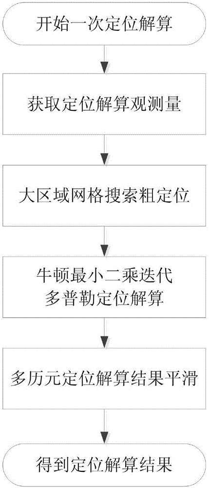
[0048] Below in conjunction with specific embodiment and accompanying drawing, the present invention will be further described:

[0049] Doppler positioning calculation method for low-orbit satellite backup navigation system. This method uses Doppler observation information and real-time ephemeris information of one or more low-orbit navigation satellites to realize ground static or low dynamic user positioning calculation. The specific implementation Steps such as figure 1 Shown, it is characterized in that comprising the following steps:

[0050] Step 1: According to the number of satellites visible to different users, obtain the satellite three-dimensional position, three-dimensional velocity and Doppler frequency observations required for positioning calculation at the same time or at different times;

[0051] Step 2: Calculate the Doppler positioning residual value based on the satellite's three-dimensional position, three-dimensional velocity and Doppler frequency obse...


PUM


Abstract

The invention discloses a low-earth-orbit satellite backup navigation system Doppler positioning calculation method, which is a Doppler positioning calculation method combining large-area grid search coarse positioning and Newton least-squares iterative calculation applicable to any number of visible satellites. The method mainly comprises the following three aspects: Doppler positioning observation variables are selected flexibly to make the method applicable to various visible satellite observation conditions; (2) position initial value determination of a Newton least-squares iterative positioning calculation method is implemented through a large-area grid search method; and (3) Doppler positioning calculation is implemented through the Newton least-squares iterative calculation method, and the positioning accuracy is further improved through an outlier-removed multi-epoch positioning calculation result smoothing method. Large-area high-accuracy Doppler positioning calculation under various conditions with different numbers of low-earth-orbit visible satellites is realized. The method has the advantages of lower computational complexity and higher positioning accuracy.

Description

technical field [0001] The invention relates to a Doppler positioning solution method for a low-orbit satellite backup navigation system, in particular to a Doppler positioning solution that is applicable to large-area grid search coarse positioning and Newton least squares iterative calculation that is applicable to any number of visible stars method. Background technique [0002] A large number of low-cost navigation terminals without special anti-jamming measures will not be able to work in the complex electromagnetic interference environment of the GNSS navigation system. In the north and south polar regions, due to the low inclination design of the GNSS system constellation, the coverage is greatly reduced. Therefore, building a GNSS backup radio navigation system is an important way to improve the availability of GNSS navigation systems. [0003] Low-orbit satellites have the characteristics of wide coverage, all-weather work, and good observability. Micro-nano satell...

Claims


Application Information

Patent Timeline
Patent Type & Authority Applications(China)
IPC IPC(8): G01S19/42
CPCG01S19/42
Inventor 邓志鑫范广伟何成龙
Owner NO 54 INST OF CHINA ELECTRONICS SCI & TECH GRP
Why Eureka
Try Eureka